
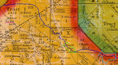
A detail from the 1858 Hopkins Map of Cuyahoga County. Used courtesy of Rails and Trails, original courtesy of the Bedford Historical Society. Annotations by the author.
In 1837, two farmers, both residents of Cleveland, purchased a small, oddly shaped parcel of land (Cuyahoga County Recorder, AFN: 183904200003). The $250 purchase netted them 8.27 acres, with Coit Road on one side, and Nine Mile Creek running down the middle of it. The property, outlined here in green, was about a quarter mile south of St. Clair Avenue.
You may recall Nine Mile Creek as the source of water for the Luster Tannery (16360 Euclid Avenue, East Cleveland), about a mile upstream. The structure, built for tanning leather in the 1850s, is a major early industrial landmark. The Luster property is outlined in light blue
The two men who purchased the land, Cornelius Thorp and Isaac Page, both lived in the area. Cornelius, at the time, was 30 years old, and was married, with three or four children. Isaac was a few years older, also married and the father of at least a couple children.
Both had farms of a decent size - Isaac Page's amounted to 62 acres, while Cornelius Thorp's farm was about 40 acres.
Why, then, did they purchase the land?
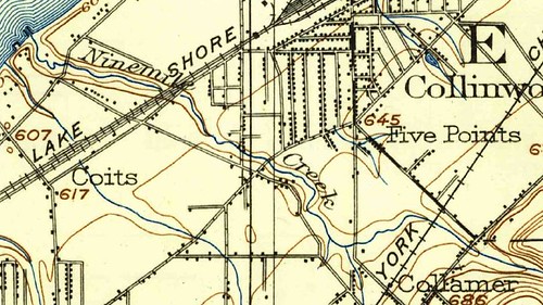
This detail of a 1903 USGS topographical map, covering about the same area as the one used to open this story, helps illustrate why. Note that Nine Mile Creek seems to enter a ravine at about the point where the sawmill is located (to the left of the "k" in "Creek"). Perhaps there was even a falls. Whatever the case, there would probably have been significant water power at the site.
Water power was very important in the early to mid 19th cenutry - other than steam engines and manual labor, it was the only way one could power anything. Even on a tiny creek, a small dam could store up enough water to power a mill for a couple hours a day.
To take advantage of the water power, a sawmill was built on the site, as illustrated in the 1858 map that I lead with. When was it built? I haven't been able to locate any information relating to that. One might suspect that construction began soon after the purchase, unless they bought the land speculatively.
Thorp and Page probably operated the mill part-time - the 1850 and 1860 U.S. Censuses list their occupations as "farmer". It was quite common at the time to do other work to supplement farm income, so this does not seem strange. However, as of 1860, Isaac's son, Isaac Morris (or Maurice) Page lists his occupation as "sawmill" - perhaps running the business full time. A decade later, however, he is listed again as a farmer.
There is only one other sawmill pictured in East Cleveland township on the 1858 Hopkins map - a steam driven one on Shaw Brook, operated by Henry Coit, shown in the far left of the detail above. This suggests relatively little competition in the immediate area.
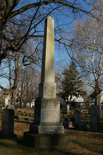
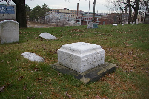
The grave of Isaac Page (the father) is marked by this obelisk, in East Cleveland Township Cemetery.
A small obelisk, mostly buried, marks the Thorp family plot at First Presbyterian Churchyard, in East Cleveland.
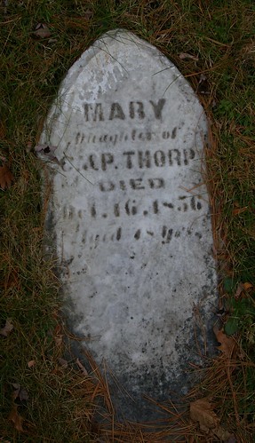
The only name visible is that of Cornelius's daughter, Mary. It'll be worth digging up the fallen obelisk and replacing it on its mount, to see if the names of other family members are noted.
These weren't the only mills in the immediate area - there were more in Euclid, as detailed in Mills & Salt, on Bluestone Heights. Still, this example represents an interesting piece of our early industrial history.
Nice work. But what I'm curious about is what happened to Ninemile Creek?
ReplyDeleteThanks!
ReplyDeleteNine Mile Creek, like most of the other streams in the area, was put into a culvert so that the land could be filled in and "better utilized" - essentially, so that more businesses and hosues could be built.
I recently located a great group of photographs illustrating this process for Nine Mile Creek, and hope to be able to have them scanned and posted here within the next couple weeks. My original intent was just to illustrate the landscape prior to culverting, but since you ask, I think it's worth showing the process, too.
Very interesting!! I love digging into what used to be - loved your book too!
ReplyDeleteMore good work, Christopher. The area’s three early maps (Blackmore 1852, Hopkins 1858 and Lake 1874) hold valuable placemarks relating to early settlers and local natural features. Hopkins (1858) was well made and reflects the all-important early steam times. Hats off to Christopher for finding two mill points on Nine Mile Creek—the stream that everyone has neglected. On the 1903 map, I’ll bet that the McIlrath Run blue spot (above the Collinwood “o”) represents an old ice pond.
ReplyDeleteDuring the early nineteenth century, the East Side faced the region’s first stage of industrialization. Natural resources cost just the price of the land; the global market lay within several hundred yards of any one mill; steam technology was a real force. The demise of the lake plain forest is an interesting case. Water-powered sawmills arose in the 1810s. Steam-powered sawmills replaced them in the 1850s. Using such localized facilities, the trees quickly went to house and ship timbers, house siding and shakes, railroad ties, charcoal for Cleveland townhouse fireplaces, and fuel for every other kind of fire. By 1860, the forest was gone. We’ve lost an appreciation for the Wild West-like local dynamics, including the destruction of local natural features. Identifying small streams and early mills (and family operators) is a way to build interest and knowledge. We twenty-first century residents must return to pioneering. It's time daylight the streams and re-grow the forest.
Thank you for that insight and background, Roy.
ReplyDeleteChristopher, the conical brick structure I mentioned to you is one half mile upstream from the Luster Tannery building. Nine Mile Creek is in the culvert at that point, but the structure is on the open feeder stream running down from Cleveland Heights. The best way to reach the structure is walk up Belvoir a half mile until you reach the Cleveland Hts. city limits, and then head down the bank to the right. Of course, there are no sidewalks, but the concrete drainage channel beside the road is quite walkable. (No place to park a car, but a bike would work, of course.) The photo of it is 47 of 52 in my first Nine Mile Creek album at http://www.facebook.com/media/set/?set=a.1819180432827.2102269.1039645808&type=3&l=f6eeb41941
ReplyDeleteI went over to Luster Tannery building and took some photos. Naturally, the sun went away about when I got there. It is precisely .5 mile up Belvoir (up Nine Mile) to the site of the brick structure. However, one wouldn't want to walk up Belvoir to reach it, since there is almost no shoulder or no sidewalk. Instead, it is a much better half mile walk down from Torbenson Dr. which intersects with Belvoir up the hill. Going down you have the fairly large concrete drainage channel to walk in. As you walk down you reach the Cleveland Hts. city line in about .3 mile. At that point, Nine Mile Creek, which has been open in its ravine all the way, over a mile, from the Princeton Rd. intersection, is put into its culvert. You walk down another .2 mile and you get to where the Oxford (Aetherstone/Randolph) feeder stream flows past the brick structure and then into an opening which adds it to the main Nine Mile Creek culvert. That point is right at the East Cleveland line (probably not a coincidence.) When the brick structure was built I am quite sure it was right on Nine Mile Creek at the point where the feeder stream entered the Creek.
ReplyDeleteThank you! I'll be sure to check that out as soon as I'm able.
ReplyDelete