Thursday, May 23, 2013

Farmhouse in the City

Greek Revival farmhouse

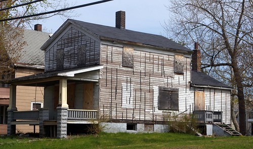
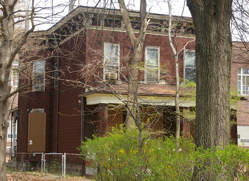
This house, at 1209 East 71st Street - just north of Superior - has been on my radar for a long time. In fact, it was the subject of one of my very first stories here.

Try to imagine the house as it was at the time it was built, 160 years ago. Remove the porch. The house would have sat on a rise, a couple of steps leading up to the front door. The windows on the front of the house, on the first floor, had a somewhat ornate trim, as did the front door. The windows, two over two, would have been flanked by shutters, perhaps in dark green, in contrast to the white of the house.

Clemen N. Jagger residence

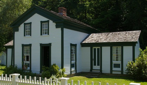
The color scheme might have been something along the lines of the Clemen N. Jagger residence, now at Hale Farm and Village. The first floor windows on the front might have had panels underneath, like this structure, or they might have been triple-hung - what I do know is that the original window trim extended downward to a line even with the bottom of the doorframe.

It was a simple structure, but with good proportions, on a relatively small (ten acre) lot.


Greek Revival house - foundation detail

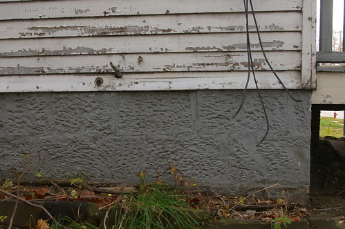
On the exterior, the house has plenty to tell us. The foundation, now covered with a layer of paint, bears the tool marks of the people who quarried and cut it.

Hand-hewn timbers

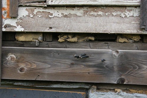
While most of the framing for the house was cut in a sawmill, the largest timbers were hewn by hand. One can be seen here, underneath a bit of trim.

Siding detail, W. Lewis residence

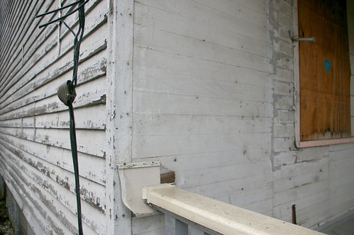
A closer look at the front of the house illustrates the flush siding - an uncommon detail. One can also see, in the paint, the outline of the trim that originally flanked the windows - a helpful piece of information for the party that chooses to fix up this house.

This house plays a signficant role in illustrating the way this neighborhood changed and grew over time.


William Lewis was born on 3 April 1809, in Westport St. Mary, Malmesbury, Wiltshire, England. His wife, Mary Anne Ponting Lewis, was born 1814, also in England. In 1847, they immigrated to the United States with their four children: Thomas (born 1838); George (born 1840); Jane (born about 1842); and Edward (born about 1845). By 1850, they were farming in East Cleveland, Ohio. (Sources: Find a Grave records for William Lewis and Mary Anne Ponting Lewis, 1850 and 1860 US Census).

1209 East 71st street Google Maps

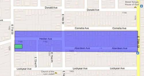
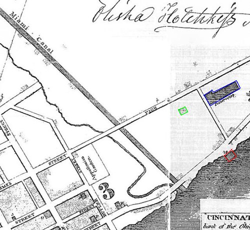
In September, 1852, they purchased, for $500, a ten acre parcel facing Becker Avenue - now East 71st Street. (Cuyahoga County Recorder, AFN: 185312190004 ) The parcel extended eastward to what is now East 79th Street. The original property is shown in blue on this map - the location of the house, in green.

1897-10-10-p4
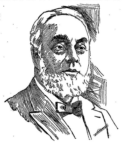
Published in the Cleveland Plain Dealer, 10 October 1897, page 4. Used courtesy of Cleveland Public Library.

The seller was one Edward Lewis, also from Wiltshire, England. He had risen to prominence within the iron and steel industry by the time this portrait was made, in 1897. His relationship, if any, with William Lewis is unclear.

At the price, it's plausible that the house had just been built - especially if Edward Lewis was a relative and was giving William a good deal. If not, the house was built soon after.

The 1860 US Census lists two more children: William (born about 1848) (henceforth William, Jr.) and Benjamin (born about 1851). It's unclear why William, Jr. wasn't numerated in the 1850 census.

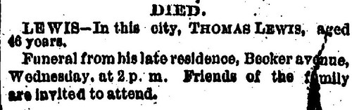
William Lewis died July 30, 1854, at the age of 45. He was buried in Woodland Cemetery. I have not been able to locate any documentation as to the cause of death. (Find a Grave William Lewis.)

View of the Ohio State Fair Grounds, 1856
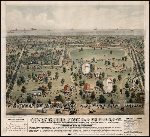
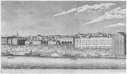
View of the Ohio State Fair Grounds, 1856. A hand-colored print (1856) by Klauprech & Menzel. Used courtesy of the Barry Lawrence Ruderman Antique Maps.

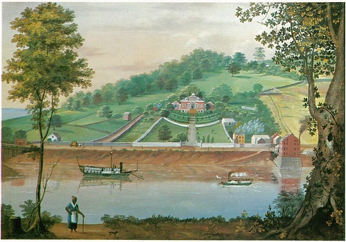
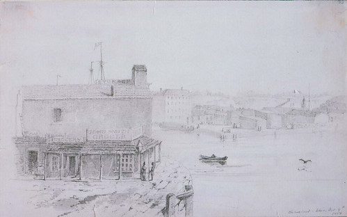
The family would have likely attended the 1856 Ohio State Fair, held just a mile and a quarter to the east.

By 1858, there were neighbors on either side, both occupying similarly sized (and shaped) lots. The family remained at this house, and by 1860, the value of the property was listed as $4,000.

Draft
Used courtesy of the National Archives, Ancestry.com, and Cleveland Public Library.

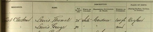
Thomas Lewis and George Lewis both registered for the draft in 1863. Their occupation is listed as "gardener". How this is different from "farmer", which appears far more frequently, is unclear.

Mary Lewis died 11 December 1863. She was buried alongside her husband at Woodland Cemetery. (Find a Grave: Mary Anne Ponting Lewis)

George Lewis and Jane Lewis transferred their shares in the property to Thomas Lewis, in 1863. (Cuyahoga County Recorder, AFN: 186302250002)

Thomas Lewis married Amelia Gibbs. They raised several children in the house: Celia Jane Lewis (born 23 October 1865); Frank J. Lewis (born 1866); William E. Lewis (born July, 1870); Thomas E. Lewis (born 9 July 1873); Charles A. Lewis (born January, 1878); and Sarah E. Lewis (born December, 1879). Arthur Lewis, born November 1875, died the following month, from whooping cough.

By 1874, the area was becoming more developed. The Lewis children would have attended a brick schoolhouse, built at the corner of what is now Carl Avenue and Addison Road, a walk of abuot a fifth of a mile.

The best frame Italianate house on the east side

The larger farm lots were beginning to be split up to build residences. Some were massive, grand structures, like this house, at 6512 Superior, which I've written about in detail. (See: The best frame Italianate house I've seen in Cleveland and Threatened: The best frame Italianate house on Cleveland's east side)

Italianate house on Superior

On the opposite side of the street, the Beckenback residence has a similarly interesting story. Like the house facing it, it retains significant interior detail.

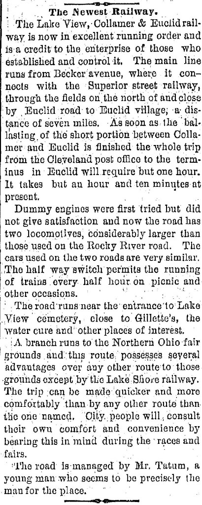
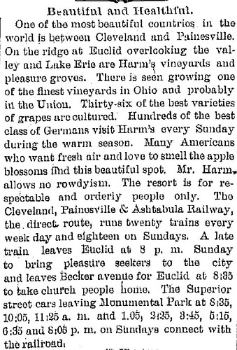
The biggest change to the immediate surroundings came in the form of the Lakeview, Collamer, and Euclid Railway, which ended just a couple hundred feet up Becker Avenue (now East 71st Street).

1876-06-23-Page4
Published in the Cleveland Plain Dealer, 23 June 1876, page 4. Used courtesy of Cleveland Public Library.

1880-05-08-p4
Published in the Cleveland Plain Dealer, 8 May 1880, page 4. Used courtesy of Cleveland Public Library.

449 Camp Gilbert
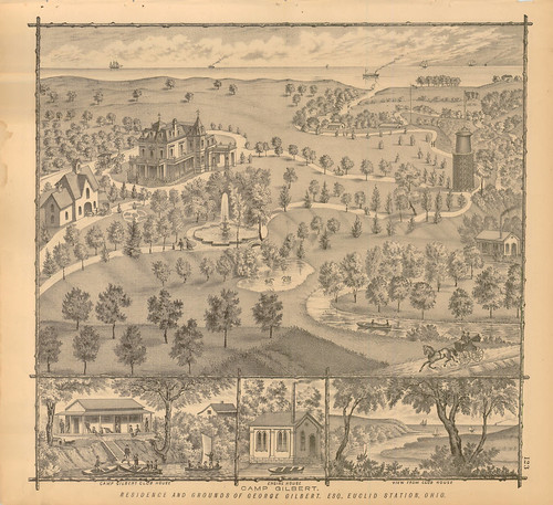
Residence and Grounds of George Gilbert, Esquire, Euclid Station, Ohio. From the 1874 Lake Atlas of Cuyahoga County, Ohio. Used courtesy of Cleveland Public Library.

Passengers might have used the railway to visit Camp Gilbert, at the mouth of Euclid Creek.

The following clipping, in addition to illustrating storm damage (front page news!) provides us with a vital bit of history - this house did, in fact, have shutters.

1876-12-16-p1
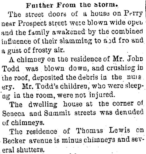
Published in the Cleveland Plain Dealer, 16 December 1876, page 1. Used courtesy of Cleveland Public Library.

1877-02-10-Page4
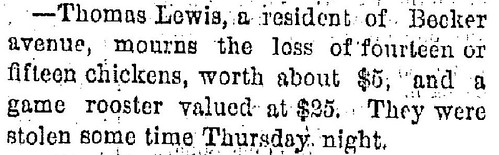
Published in the Cleveland Plain Dealer, 10 February 1877, page 4. Used courtesy of Cleveland Public Library.

This quantity - an unknown portion of the Lewis flock - strongly suggests that at least part of their income came from selling either eggs or chickens.

1880-04-13-p5
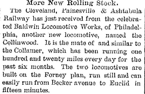
Published in the Cleveland Plain Dealer, 13 April 1880, page 5. Used courtesy of Cleveland Public Library.

This purchase suggests that the railway was busy.

A beer garden was built at the railway terminal - next door to the Lewis house. As this 1885 article suggests, it caused some problems.

There's nothing useful that I can say about the following articles.

1885-07-13-Page1]
Published in the Cleveland Plain Dealer, 13 July 1885, page 1. Used courtesy of Cleveland Public Library.

1885-07-14-Page1
Published in the Cleveland Plain Dealer, 14 July 1885, page 1. Used courtesy of Cleveland Public Library.

1885-07-14-page3
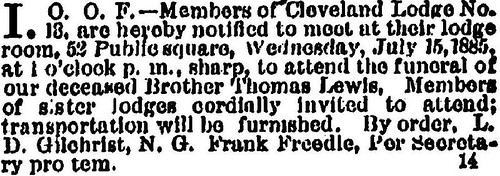
Published in the Cleveland Plain Dealer, 14 July 1885, page 3. Used courtesy of Cleveland Public Library.


1885-10-01-p3
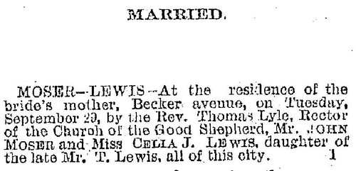
Published in the Cleveland Plain Dealer, 1 October 1885, page 3. Used courtesy of Cleveland Public Library.

In 1885, Celia Lewis married John Moser in a ceremony at the Lewis family home. John Moser moved in to the house, where they had two children: Grace M. Moser (born 1886) and John Lewis Moser (born 1887).

The Lewis / Moser family remained in the house through the end of the 19th century. The ten acre lot was gradually split into smaller and smaller peices, as this became a residential neighborhood. In 1900, Amelia Lewis sold the house to Eliza and William Lehmann. (Cuyahoga County Recorder, AFN: 190003230029)


In the next article, we'll see how this house (and the neighborhood) changed during the course of the 20th century.
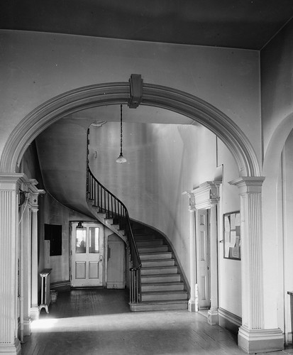
Friday, May 3, 2013

Granville, Ohio, in the 1830s - Two Views or Two Copies of the Same View?

[Granville Female College]
[Granville Female College]. A drawing (1830s?). Used courtesy of Garth's Auctions.

When I first saw the thumbnail for this drawing in the current catalogue at Garth's Auctions, I knew the composition was familiar - namely, it was a subject illustrated in a lithograph by one M. French, made between 1835 and 1839, in the collections of the American Antiquarian Society. The date for the drawing was listed as "mid 19th century" - I hoped that the lithograph might provide some context - most likely the size of the trees - that would give a more specific date.

On further examination, I've come to see that they're a lot closer in composition - and likely date - than I had initially guessed.

Female academy, Granville Ohio
Female academy, Granville Ohio. A lithograph (between 1835 and 1839) from a drawing by M. French. Printed by Bufford's Lith. Used courtesy of the American Antiquarian Society.

There are quite a few elements shared by both images. A woman in a white dress stands in the front door of the Academy, with two women in dark dresses immediately to the right. The chimney of the house to the left ends up centered in a second floor window in both cases - even though they have rather different perspectives. The trees both show approximately the same amount of growth. Many (though not all) of the same windows are open on the front of the structure. There's even a similarity in the toning of the sky.

The drawing features central chimneys, while the print has more of them, smaller in size. In the drawing, the gable has a single window, while in the print, there are two smaller ones. In the print, the house is closer to the street, while in the drawing, it appears to have been moved back. In the drawing, which has a more crude sense of perspective, we can see more detail in the house to the right. The print has a different fence from the drawing.


It seems likely that these two images share some sort of common source - but what that source is, I do not know.

They have enough in common that one might start to consider if the drawing was a copy after the print - but the lack of the same skill in perspective tends to refute this.

My guess - and it is a guess - is that these were the product of two students, working under the same teacher at Granville Female Academy at the same time. On a given day, they went out and made sketches together. They included some suggestions about perspective - and some idealized items (the people walking on the street) as suggested, perhaps by the teacher. It might be worth the time to see if an "M. French" was, indeed, a student there at that time.

This pair appears to provide a look at how two artists, one more skilled than the other, approached the same subject at the same time.

Wednesday, April 3, 2013

The Strange Disappearing Houses of the Lomond Neighborhood, in Shaker Heights, Ohio


My colleague, Korbi Roberts, put together this video, The Strange Disappearing Houses of the Lomond Neighborhood, in Shaker Heights, Ohio. It illustrates that the issues concerning the demolition of homes in historic neighborhoods are not limited to the inner city.

Rather than reading my continued ramblings (I could go on and on, you know) please take a look at the video.

Friday, February 15, 2013

Cincinnati's Kilgour house and Mount Adams - This Time in Winter!

Ohio River Landscape / The Steamboat Washington
Ohio River Landscape / The Steamboat Washington. An oil painting (circa 1820). Used courtesy of Mr. and Mrs. Samuel Schwartz, Paterson, NJ. Reproduced from Folk Painters of America (1979) by Robert Bishop.

As part of my research, I've been reading Artists in Ohio, 1787-1900: A Biographyical Dictionary, (2000) edited by Mary Sayre Haverstock, Jeannette Mahoney Vance, and Brian L. Meggitt. This 1066 page tome includes perhaps 10,000 artists active in Ohio in or before 1900. I've been reading it, seeking out all of the artists active in or before 1865.

Two weeks ago, I identified the painting shown here as a Cincinnati scene. At center is the Kilgour house, built about 1820. To the right, the city's first water works. At the left, Deer Creek empties into the Ohio River.

The Forest Queen in Winter
The Forest Queen in Winter. A painting (1857) by Martin Andreas Reisner. Used courtesy of Richard and Jane Manoogian. Image used courtesy of The Athenaeum.

This morning, while reading Artists in Ohio, 1787-1900, I came across a citation for this 1857 painting, The Forest Queen in Winter by Martin Andreas Reisner. The authors noted that, in 1857, Reisner "visited Cincinnati (Hamilton), a portrino of whose riverfont features prominently in The Forest Queen in Winter (Manoogian Collection)."

To my surprise, I was able to locate a high quality image of the painting. It appears to be based, in part, on the same landscape! Mount Adams is present in the background. The Kilgour house is present, just to the right of center. The Little Miami Railroad runs along the river.

Detail, Cincinnati Panorama
Detail, Cincinnati Panorama. A daguerreotype (1848) by Charles Fontayne and William S. Porter. Used courtesy of the Public Library of Cincinnati and Hamilton County.

When compared with this photograph, made nine years earlier, it's obvious that Martin Andreas Reisner took considerable liberties. The commercial buildings are all gone - either he envisioned the landscape without them, or, perhaps, he was working based on an earlier view of the area. On the other hand, he retains what appears to be a bit of commercial activity based around the (considerably smaller) Deer Creek. Yet if we are to see this as something based on an earlier work, why the inclusion of the railroad?


This view clearly involves a bit of imagination and artistic license. This doesn't diminish its value as a look at Cincinnati in the 1850s. Further, given the rarity of winter views, it seems perfect for a day like today.

What do you see in it?

Wednesday, February 13, 2013

New Find! First* Painting of Cleveland in Color!

Lake Erie, From Cleveland
Lake Erie, From Cleveland. A watercolor painting (July, 1833) by Seth Eastman. Used courtesy of Sloans and Kenyon Auctioneers and Appraisers, Bethesda, Maryland.

When I think about downtown Cleveland and the mouth of the Cuyahoga, images of industry and commerce come to mind. While I know it wasn't always this way, this area has so long been the heart of the city it's hard to imagine it otherwise. Even Thomas Whelpley's four views of the city, published in 1834, show a quickly-growing city.

It's for that very reason that this watercolor, made by Seth Eastman in July, 1833, is so special - it represents the earliest detailed painting I'm aware of of the mouth of the Cuyahoga River.

Eastman probably came through Cleveland en route from Fort Snelling, in Minnesota, to West Point, New York, where he had received a teaching appointment. He appears to have been looking west from what is now the intersection of West Sixth Streets and Lakeside Avenue.

In the foreground, to the right, there's a group of five Native Americans, said to be Iroquois. A few people sit on the hillside, where a row of fenceposts is visible. Closer to the river are a couple of buildings, one of which appears to be a log house. On the river, there are what could be canal boats. The pier and harbor light are also present. The hill at the mouth of the Cuyahoga, on the west bank, had not yet been flattened. A steamship, with a cloud of black smoke, sails on Lake Erie. In the distance, we see what would come to be called the "Gold Coast."

These things are all significant.

There are almost no historic images of Native Americans in Ohio. Of those, virtually all were either made years after the fact, based on memory and conjecture or were made by artists who hadn't seen the people in question. I can't think of another painting (within the scope of my current research - before 1866) that documents Native Americans in Ohio at the time the painting was made.

The presence of a log building is also notable - there are very few known in northern Ohio. While there were a good number built (though not in such numbers as in the southern part of the state) they would have usually been covered with siding as soon as was practical, as a matter of fashion and appearance.

Further, this painting documents Cleveland at a point just before it underwent a major transformation. With the completion of the Ohio and Erie Canal, Cleveland and the interior of Ohio were opened up to commerce. The cost of shipping goods dropped considerably. Cuyahoga County's population would more than double between 1830 and 1840. It would almost double again by 1850. The landscape illustrated here would soon be gone.

Cleveland, 1853
Cleveland, 1853 A hand colored lithograph (1853) by B.F. Smith, after a drawing by J.W. Hill. Published by Smith Bros. & Co. Used courtesy of the Chicago Historical Society. Reproduced from Bird's Eye Views: Historic Lithographs of North American Cities by John W. Reps.

This view, made 20 years later, from the west bank of the Cuyahoga, looking east, shows the magnitude of the change. While the west bank still has plenty of vacant land, the east side and downtown are mostly built up. Warehouses line the banks of the Cuyahoga River. To the right, we see both the Cuyahoga River and the narrower Ohio and Erie Canal.

Cleveland, Ohio, From Brooklyn Hill Looking East
Cleveland, Ohio, From Brooklyn Hill Looking East. A hand-colored etching (1834) by Thomas Whelpley. Engraved by Milo Osborne. Used courtesy of Cleveland Public Library.

The point from where Seth Eastman made the watercolor is illustrated in this 1834 print, Cleveland, Ohio, From Brooklyn Hill Looking East.

Whelpley detail
Detail, Cleveland, Ohio, From Brooklyn Hill Looking East. A hand-colored etching (1834) by Thomas Whelpley. Engraved by Milo Osborne. Used courtesy of Cleveland Public Library.

This detail, taken from the left side of the print, illustrates the location more clearly. Eastman's vantage point is indicated by the red arrow. Note the row of fenceposts, illustrated in the painting, to the left of the arrow. The yellow arrow indicates the location of the Cleveland lighthouse.

Harbor Light
Detail, Lake Erie, From Cleveland. A watercolor painting (July, 1833) by Seth Eastman. Used courtesy of Sloans and Kenyon Auctioneers and Appraisers, Bethesda, Maryland.

It's worth noting the presence of the harbor light, at the mouth of the Cuyahoga River. This structure was likely completed a year or two earlier.

[Cleveland harbor]
[Cleveland harbor] A print (1837) by Charles Whittlesey. Published in the Annual report on the geological survey of the State of Ohio (1837). Used courtesy of Ohio State University and the Internet Archive.

The pier upon which the harbor light was built is illustrated, top and center, in this drawing - letter "F". There's a square, on the right (east) side of the river that provided the foundation for the structure.

Cleveland Lighthouse on the Lake Erie
Cleveland Lighthouse on the Lake Erie. A hand-colored engraving (1839) by Pierre Eugène I. Aubert, after a drawing by Karl Bodmer. Published in Reise in das innere Nord-America in den Jahren 1832 bis 1834 (1839) by Maximilian Wied. Used courtesy of the Beinecke Library, Yale University.

I've often heard suggested that this 1839 print, based on preliminary drawings and/or paintings made in 1834, doesn't actually portray the Cleveland lighthouse. What then, I ask, does it portray? The response tends to be a mumble that it's probably somewhere else.

It's been pointed out that the structure in the print doesn't look like the Cleveland lighthouse, nor is it located up on the hill like the Cleveland lighthouse was - see the point noted by the yellow arrow above.

Seth Eastman's painting, combined with Charles Whittlesey's map of the harbor seem to indicate that Karl Bodmer's print, Cleveland Lighthouse on the Lake Erie, does, in fact, depict a Cleveland scene. It's just that the structure being illustrated isn't the lighthouse but rather, the harbor light. Perhaps this was a translation issue.

Bodmer's vantage point appears to have been from the west bank of the Cuyahoga. It's worth noting that the physical relationship between the ship and the harbor light appears to be about the same in Seth Eastman's painting and Karl Bodmer's print. What does this mean? I do not know.


View of Inscription Rock on South side of Cunningham Island, Lake Erie
View of Inscription Rock on South side of Cunningham Island, Lake Erie. A print (1852) The print is based on a drawing by Seth Eastman created in 1850.
C. E. Wagstaff & J. Andrews (Engraver) Published in Historical and statistical information respecting the history, condition, and prospects of the Indian tribes of the United States; collected and prepared under the direction of the Bureau of Indian Affairs per act of Congress of March 3rd, 1847, Volume 2 (1852) by Henry Rowe Schoolcraft. Image used courtesy of the Ohio Historical Society.


Seth Eastman is best known for the work he did portraying Native Americans - the greatest bulk of which appeared in Henry Rowe Schoolcraft's Historical and Statistical Information, Respecting the History, Condition and Prospects of the Indian Tribes of the United States, published in the 1850s. This view of Kelley's Island is one such image.

Sculptured Inscriptions on Rock, South Side Of Cunningham's Island, Lake Erie
Sculptured Inscriptions on Rock, South Side Of Cunningham's Island, Lake Erie. A pen and ink drawing (October 10, 1850) by Seth Eastman. Reproduced from Seth Eastman: A Portfolio of North American Indians (1995) by Sarah E. Boehme, Christian F. Feest, and Patricia Condon Johnston.

His record of Inscripion Rock on Kelley's Island, the original drawing for which is shown here, remains the best document that we have of this important, but now rather eroded, pictograph group.

Inscription Rock, North Side of Cunningham's Is., Lake Erie
Inscription Rock, North Side of Cunningham's Is., Lake Erie. A print (1852) by Seth Eastman, from a sketch made October 12, 1850. Published in Historical and statistical information respecting the history, condition, and prospects of the Indian tribes of the United States; collected and prepared under the direction of the Bureau of Indian Affairs per act of Congress of March 3rd, 1847, Volume 2 (1852) by Henry Rowe Schoolcraft. Used courtesy of Cornell University Library and the Internet Archive.

Another boulder, now lost, inscribed with pictographs was present on the north shore of Kelley's Island, near the present state park campground.

Eastman's documentation of the island also included two earthworks.

Cleveland, Ohio Grocery Store
Cleveland, Ohio Grocery Store [John Smith Grocer]. A drawing (October 9, 1850) by Seth Eastman. Used courtesy of the Museum of Fine Arts, Boston.

In the course of his travels, Seth Eastman made drawings of the cities he passed through, along with other items not relating to the subject of his research. The Museum of Fine Arts, Boston, has drawings by Eastman of Fairport Harbor and Sandusky, in addition to this one, of a grocer on the Cuyahoga River, in Cleveland.

After the initial discovery of this painting wore off, I started to suspect that the watercolor painting, Lake Erie, From Cleveland, might have been made in the 1850s, based partially on his observations in the 1830s. I couldn't locate any works this early by Seth Eastman, and the combination of factors in this painting - the portrayal of the landscape and the presence of Native Americans, among others - just seemed too good to be true.

So I did more research. I found that the layout of the harbor is consistent with Cleveland in 1833. The number and nature of buildings corresponds reasonably with Whelpley's print of a year later. And the improvements made in the 1840s are not present. Further, the technique of the painting is not as refined as Eastman's later works.

I'm confident, now, that Lake Erie, From Cleveland depicts Cleveland in July of 1833. It provides a rare glimpse into the landscape of this region as it used to be.

This watercolor is to be auctioned at Sloans and Kenyon this Sunday. Their estimate is $80,000-$150,000 - meaning that the bidding will likely start at $40,000.


* The Seth Pease 1796 map of Cleveland (see a drawing based upon said map) features a tent with a couple men situated by the mouth of the Cuyahoga River. However, this appears, to my eyes, to be merely added as a visual device, rather than an attempt to illustrate the location. For that reason, I don't count it as a painting of the city.

Correction: Janice B. Patterson, author of Cleveland's Lighthouses, pointed out to me that where I said "breakwater", I meant "pier". I corrected the two instances of this term. She noted that "There were no breakwaters in the 1830s -- they were built in the 1870s. I think what you are calling a breakwater was actually just a wooden pier, built on pilings and possibly reinforced with stones."

Tuesday, January 29, 2013

Cincinnati in the 1820s - Identifying the Location Depicted in "Ohio River Landscape"

Ohio River Landscape / The Steamboat Washington
Ohio River Landscape / The Steamboat Washington, an oil painting, circa 1820. Used courtesy of Mr. and Mrs. Samuel Schwartz, Paterson, NJ (as of 1987). Reproduced from Folk Painters of America (1979) by Robert Bishop.

When I came across this painting in Robert Bishop's Folk Painters of America, I decided to add it to my ongoing research collection, Ohio Art through 1865, even though it felt more like something that one might find in the American south, because the odds were better than even that, at least in theory, it depicted an Ohio scene.

The Ohio River is 981 miles long. Of that, about 449 miles is in Ohio. (I was unable to find a source for the portion in Ohio, so I went to work in Google Maps. It's worth noting that increasing the precision of the line at the point that I'm at on this map does not have a significant effect - 20 minutes of additional precision had a net effect of less than a third of a mile.)

However, when I added it to the set, I assumed, eyeballing, it, that perhaps 60% of the Ohio River was in Ohio - so a site described as Ohio River Landscape had better than even odds of being in Ohio - at least in a situation like this where both sides of the river are included.

I've been collecting all the images that I can find illustrating Ohio and created before 1866, without regard to quality - a low quality image can at least act as a placeholder.

Topographical Map of the City of Cincinnati, from Actual Survey by Capt. H. L. Barnum
Topographical Map of the City of Cincinnati, from Actual Survey by Capt. H. L. Barnum A print (1831), engraved and published by Doolittle & Munson. Used courtesy of the Cincinnati Historical Society Library. Digitized as part of Art as Image; Prints and Promotion in Cincinnati, Ohio, Alice M. Cornell, editor.

A couple days ago, a colleague mentioned an 1831 map of Cincinnati in his possession. I searched my image collection and came up with the map you see above. When I saw the images in the border with fresh eyes, I immediately recognized the composition - look on the top border, second image from the left.

One can see, even in the tiny image, the large building, right at the water's edge. The slope of the hill is similar, and there's the building with two small wings halfway up the hillside.

A higher resolution version of this map would surely verify that this painting depicted the same scene illustrated in the scene. Unfortunately, I could not locate one online.

In looking for a copy of the map, I came across this catalog record, from the Clements Library at the University of Michigan. Among other things, it identifies the structures illustrated on the border of the map:
Water works; Cincinnati; Mouth of Licking River; Sycamore Street Church; Second Presbyterian Church; Commercial Bank; Unitarian church; Christ's Church; U.S. Branch Bank; Roman Catholic church; Methodist church; Baptist church; Medical college.

Cincinnati
Cincinnati, (March, 1834) by Doolittle & Munson. Used courtesy of the Cincinnati Museum Center. Reproduced from Bulletin of the Historical and Philosophical Society of Ohio, June, 1945.

After working by process of elimination for a bit, I came to the conclusion that the first three subjects were probably the three center images. I'd seen the composition at center before - a view of Cincinnati shown here. The image immediately to the right of it looked to, plausibly, be the mouth of a river, which would make the one to the left - the subject of our painting - the Water Works.

I was able to find, on Sandman Cincinnati, several maps that help illustrate the location depicted here.

1831 Cincinnati
Detail, Topographical Map of the City of Cincinnati, from Actual Survey by Capt. H. L. Barnum A print (1831), engraved and published by Doolittle & Munson. Used courtesy of Sandman Cincinnati.

On this map, the water works is outlined in red, a house in green, and reservoirs, in blue. The Miami and Erie Canal empties into the Ohio River here, near the mouth of Deer Creek. The map provides some hint that we may be on the right track, but it's hardly conclusive.


View Larger Map

For comparison, this map illustrates the same approximate area in Cincinnati today.

1838
Detail, City of Cincinnati From Actual Survey by Joseph Gest (1838). Used courtesy of Sandman Cincinnati.

This detail of an 1838 map shows the same area. Near the center is a square, flanked by two smaller squares, labeled "Kilgour's". This rather distinctive footprint is identical to that of the house illustrated in the painting.

Ohio River Landscape / The Steamboat Washington
Ohio River Landscape / The Steamboat Washington, an oil painting, circa 1820. Used courtesy of Mr. and Mrs. Samuel Schwartz, Paterson, NJ (as of 1987). Reproduced from Folk Painters of America (1979) by Robert Bishop.

To better illustrate what I think we're seeing here, let's take another look at the painting itself.

In the foreground, we see the Ohio River and its north shore, as viewed from Kentucky. A steamboat, "Washington", is visible on the river. On the right, there's a brick building with a stone foundation - the water works. A channel runs up the hillside from the water works to what appears, from this angle, to be a triangle-shaped reservoir. A grand house, owned by one "Kilgour", sits in the center. It is surrounded by a large, well manicured yard and garden. At the left, part of a bridge, over Deer Creek, is visible. The hillside appears green, and there are still quite a few trees on it.

Cincinnati Panorama
Cincinnati Panorama, A daguerreotype (1848) by Charles Fontayne and William S. Porter. Used courtesy of the Public Library of Cincinnati and Hamilton County.

This massive daguerreotype, by Fontayne and Porter, was made 20-30 years after the painting. It illustrates how much the area had changed in the intervening years. It's worth taking the time to look at in detail - the image represents the largest-scale early photograph of a city. Take a few minutes to stop and look at the extra large version - it's amazing.

Detail, Cincinnati Panorama
Detail, Cincinnati Panorama, A daguerreotype (1848) by Charles Fontayne and William S. Porter. Used courtesy of the Public Library of Cincinnati and Hamilton County.

The area illustrated in our painting is covered in the right half of plate 6 and the left half of plate 7 of the daguerreotype. Note that the Fontayne and Porter, the photographers, were at a point considerably downstream (left) of the site used by the painter.

Detail, Cincinnati Panorama
Detail, Cincinnati Panorama, A daguerreotype (1848) by Charles Fontayne and William S. Porter. Used courtesy of the Public Library of Cincinnati and Hamilton County.

Here's the same image, with the Charles H. Kilgour house outlined in green and the water works outlined in red, for greater visibility. Note that on the water works building, an addition had been made to the rear, and the roofline changed, but the distinctive structure remains the same. Likewise, an entire story had been added to the Kilgour house.

Immediately below the Kilgour house, one can see the stone bridge that was built over Deer Creek, replacing the one seen in the painting. Note, too, how much the city had been built up in the couple decades since the painting had been made.

Front (South) Elevation, Marine Hospital, Third & Kilgour Streets, Cincinnati, Hamilton County, OH
Front (South) Elevation, Marine Hospital, Third & Kilgour Streets, Cincinnati, Hamilton County, OH. A drawing (April 2, 1934) by C. Brodersen for the Historic American Buildings Survey. Used courtesy of the Library of Congress.

In the 1930s, the Charles H. Kilgour house was documented in detail by the Historic American Buildings Survey, a WPA project to record our country's most historically signfincant structures. I stumbled across these images by chance - they were labeled as the "Marine Hospital" - they only came up in my searches because they happened to include a description noting that the structure had been located at the intersection of Kilgour and Third.

Although the structure was altered considerably over time - perhaps most notably with the addition of a second floor, these drawings, compared with the painting and the 1848 daguerreotype, can help us see how it was changed. Note the Palladian window on the first floor, at the far right. One was present on at the far left as well.

Detail, South Doorway. - Marine Hospital, Third & Kilgour Streets, Cincinnati, Hamilton County, OH
Detail, South Doorway. - Marine Hospital, Third & Kilgour Streets, Cincinnati, Hamilton County, OH. A photograph (March 5, 1934) by Edgar D. Tyler for the Historic American Buildings Survey. Used courtesy of the Library of Congress.

The grand front doorway was still present in the 1930s, though the porch had been changed to something larger long before.

Kinsman House, Kinsman, Ohio
Kinsman House, Kinsman, Ohio, a photograph by I.T. Frary. Used courtesy of the Ohio Historical Society.

The front porch appears to have originally resembled the one present on the Kinsman House, in Kinsman, Ohio.

Detail, Main Hall Looking North. - Marine Hospital, Third & Kilgour Streets, Cincinnati, Hamilton County, OH
Detail, Main Hall Looking North. - Marine Hospital, Third & Kilgour Streets, Cincinnati, Hamilton County, OH, a photograph (March 5, 1934) by Edgar D. Tyler for the Historic American Buildings Survey. Used courtesy of the Library of Congress.

On entering the house, one would be greeted by this grand hall. It appears that most of the first first floor wasn't altered by the several rounds of renovations.

Detail, Doorway from Hallway, First Floor, Marine Hospital, Third & Kilgour Streets, Cincinnati, Hamilton County, OH
Detail, Doorway from Hallway, First Floor, Marine Hospital, Third & Kilgour Streets, Cincinnati, Hamilton County, OH, a photograph (March 5, 1934) by Edgar D. Tyler for the Historic American Buildings Survey. Used courtesy of the Library of Congress.

The interior woodwork ranks among the very best I've ever seen in an Ohio house from this period. In fact, I can't recall ever having seen an interior doorway like this - woodwork of this style is virtually always reserved for exteriors.


This painting does much to illustrate how Cincinnati changed between 1820 and 1850. It shows how a landscape went from being agricultural to commercial / industrial - and it illustrates it in a way that text never could.

For now, the big mystery is locating the painting itself. I'm sure that with a higher resolution image, even more could be learned.