
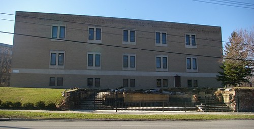
Perhaps you drive by the old Marine Hospital on Fairhill on your way to or from work. You may have noticed a wrought iron fence that appeared in front of a staircase and wondered what it is. I did - I was curious how this staircase related to the complex, which is a Cleveland Landmark.
Image courtesy of Google Maps
Until recently, this is what you would have seen from Fairhill - a concrete wall, presumably just a retaining wall.
The style of the staircase seems consistent with the rest of the complex, but if so, why was it buried? The postcard shown below may help to answer that question.

Image used courtesy of the Cleveland Memory Project
This illustrates the staircase as it was near the time that the complex was built, in the 1920s. It appears to form a sort of grand entrance to the complex.
What happened to the building shown here? Was it demolished? No, it is still standing. The building shown in the first photograph was built in front of it. This changed focus of the complex likely made the staircase from Fairhill unnecessary.
The recent excavation of the staircase helps tell part of the visual narrative of this complex. It makes the space more appealing from the street, too. The wrought iron fence was likely added as a safety measure.
Is it known why the steps are being uncovered now? The 1920s photo is beautiful, and it would be lovely as a small outdoor eating/reading area for visitors and employees.
ReplyDeleteWhen I looked at your historical photo, the stairway seemed like that of a nineteenth century estate. The Encyclopedia of Cleveland History solved the problem. “In 1929 … a new [Marine] hospital was built at E. 124th and Fairhill Rd., on a portion of the Otto I. Leisy estate.” The stairway is probably a remnant of that estate. Otto Leisy was Cleveland’s premier brewer during the late nineteenth century. His estate was grand—and built of local stone! My little knowledge of the man comes from researching a lot he once owned in Euclid Township, the land presently occupied by St. John’s Lutheran Church, on Nottingham Road at E. 174th. That subtle promontory, overlooking the Euclid Creek estuary, is the highest in the area. It was a likely place for Native American hunting camps.
ReplyDelete