Showing posts with label Cuyahoga River. Show all posts

Wednesday, February 13, 2013

New Find! First* Painting of Cleveland in Color!

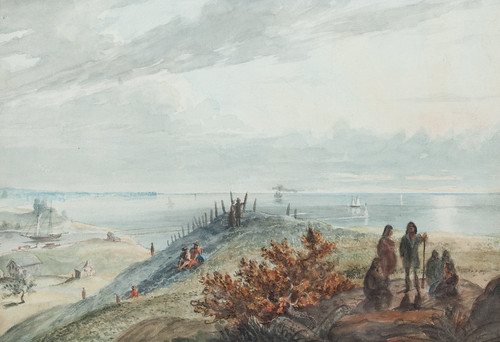
Lake Erie, From Cleveland
Lake Erie, From Cleveland. A watercolor painting (July, 1833) by Seth Eastman. Used courtesy of Sloans and Kenyon Auctioneers and Appraisers, Bethesda, Maryland.

When I think about downtown Cleveland and the mouth of the Cuyahoga, images of industry and commerce come to mind. While I know it wasn't always this way, this area has so long been the heart of the city it's hard to imagine it otherwise. Even Thomas Whelpley's four views of the city, published in 1834, show a quickly-growing city.

It's for that very reason that this watercolor, made by Seth Eastman in July, 1833, is so special - it represents the earliest detailed painting I'm aware of of the mouth of the Cuyahoga River.

Eastman probably came through Cleveland en route from Fort Snelling, in Minnesota, to West Point, New York, where he had received a teaching appointment. He appears to have been looking west from what is now the intersection of West Sixth Streets and Lakeside Avenue.

In the foreground, to the right, there's a group of five Native Americans, said to be Iroquois. A few people sit on the hillside, where a row of fenceposts is visible. Closer to the river are a couple of buildings, one of which appears to be a log house. On the river, there are what could be canal boats. The pier and harbor light are also present. The hill at the mouth of the Cuyahoga, on the west bank, had not yet been flattened. A steamship, with a cloud of black smoke, sails on Lake Erie. In the distance, we see what would come to be called the "Gold Coast."

These things are all significant.

There are almost no historic images of Native Americans in Ohio. Of those, virtually all were either made years after the fact, based on memory and conjecture or were made by artists who hadn't seen the people in question. I can't think of another painting (within the scope of my current research - before 1866) that documents Native Americans in Ohio at the time the painting was made.

The presence of a log building is also notable - there are very few known in northern Ohio. While there were a good number built (though not in such numbers as in the southern part of the state) they would have usually been covered with siding as soon as was practical, as a matter of fashion and appearance.

Further, this painting documents Cleveland at a point just before it underwent a major transformation. With the completion of the Ohio and Erie Canal, Cleveland and the interior of Ohio were opened up to commerce. The cost of shipping goods dropped considerably. Cuyahoga County's population would more than double between 1830 and 1840. It would almost double again by 1850. The landscape illustrated here would soon be gone.
Cleveland, 1853
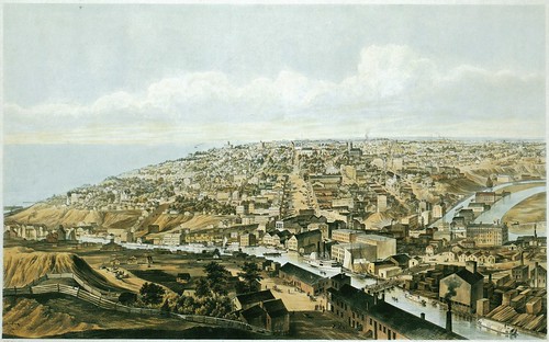
Cleveland, 1853 A hand colored lithograph (1853) by B.F. Smith, after a drawing by J.W. Hill. Published by Smith Bros. & Co. Used courtesy of the Chicago Historical Society. Reproduced from Bird's Eye Views: Historic Lithographs of North American Cities by John W. Reps.

This view, made 20 years later, from the west bank of the Cuyahoga, looking east, shows the magnitude of the change. While the west bank still has plenty of vacant land, the east side and downtown are mostly built up. Warehouses line the banks of the Cuyahoga River. To the right, we see both the Cuyahoga River and the narrower Ohio and Erie Canal.
Cleveland, Ohio, From Brooklyn Hill Looking East
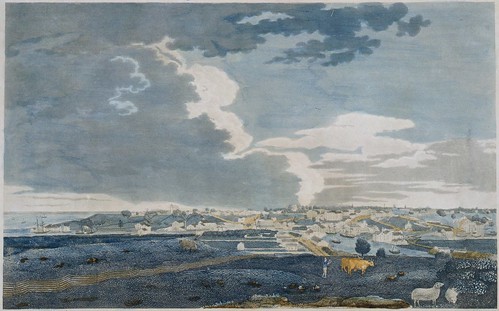
Cleveland, Ohio, From Brooklyn Hill Looking East. A hand-colored etching (1834) by Thomas Whelpley. Engraved by Milo Osborne. Used courtesy of Cleveland Public Library.

The point from where Seth Eastman made the watercolor is illustrated in this 1834 print, Cleveland, Ohio, From Brooklyn Hill Looking East.
Whelpley detail
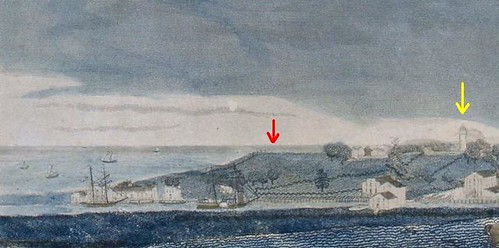
Detail, Cleveland, Ohio, From Brooklyn Hill Looking East. A hand-colored etching (1834) by Thomas Whelpley. Engraved by Milo Osborne. Used courtesy of Cleveland Public Library.

This detail, taken from the left side of the print, illustrates the location more clearly. Eastman's vantage point is indicated by the red arrow. Note the row of fenceposts, illustrated in the painting, to the left of the arrow. The yellow arrow indicates the location of the Cleveland lighthouse.
Harbor Light
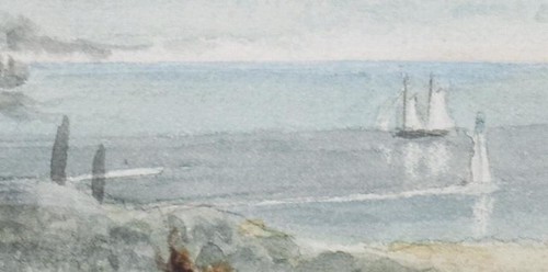
Detail, Lake Erie, From Cleveland. A watercolor painting (July, 1833) by Seth Eastman. Used courtesy of Sloans and Kenyon Auctioneers and Appraisers, Bethesda, Maryland.

It's worth noting the presence of the harbor light, at the mouth of the Cuyahoga River. This structure was likely completed a year or two earlier.

[Cleveland harbor]
[Cleveland harbor] A print (1837) by Charles Whittlesey. Published in the Annual report on the geological survey of the State of Ohio (1837). Used courtesy of Ohio State University and the Internet Archive.

The pier upon which the harbor light was built is illustrated, top and center, in this drawing - letter "F". There's a square, on the right (east) side of the river that provided the foundation for the structure.
Cleveland Lighthouse on the Lake Erie
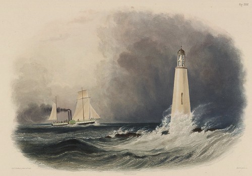
Cleveland Lighthouse on the Lake Erie. A hand-colored engraving (1839) by Pierre Eugène I. Aubert, after a drawing by Karl Bodmer. Published in Reise in das innere Nord-America in den Jahren 1832 bis 1834 (1839) by Maximilian Wied. Used courtesy of the Beinecke Library, Yale University.

I've often heard suggested that this 1839 print, based on preliminary drawings and/or paintings made in 1834, doesn't actually portray the Cleveland lighthouse. What then, I ask, does it portray? The response tends to be a mumble that it's probably somewhere else.

It's been pointed out that the structure in the print doesn't look like the Cleveland lighthouse, nor is it located up on the hill like the Cleveland lighthouse was - see the point noted by the yellow arrow above.

Seth Eastman's painting, combined with Charles Whittlesey's map of the harbor seem to indicate that Karl Bodmer's print, Cleveland Lighthouse on the Lake Erie, does, in fact, depict a Cleveland scene. It's just that the structure being illustrated isn't the lighthouse but rather, the harbor light. Perhaps this was a translation issue.

Bodmer's vantage point appears to have been from the west bank of the Cuyahoga. It's worth noting that the physical relationship between the ship and the harbor light appears to be about the same in Seth Eastman's painting and Karl Bodmer's print. What does this mean? I do not know.


View of Inscription Rock on South side of Cunningham Island, Lake Erie
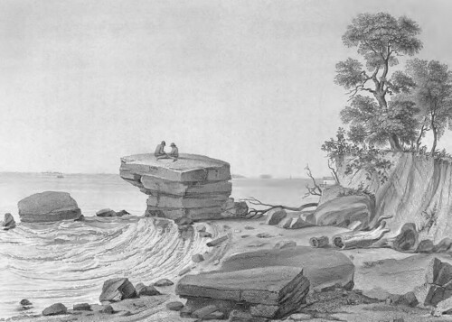
View of Inscription Rock on South side of Cunningham Island, Lake Erie. A print (1852) The print is based on a drawing by Seth Eastman created in 1850.
C. E. Wagstaff & J. Andrews (Engraver) Published in Historical and statistical information respecting the history, condition, and prospects of the Indian tribes of the United States; collected and prepared under the direction of the Bureau of Indian Affairs per act of Congress of March 3rd, 1847, Volume 2 (1852) by Henry Rowe Schoolcraft. Image used courtesy of the Ohio Historical Society.


Seth Eastman is best known for the work he did portraying Native Americans - the greatest bulk of which appeared in Henry Rowe Schoolcraft's Historical and Statistical Information, Respecting the History, Condition and Prospects of the Indian Tribes of the United States, published in the 1850s. This view of Kelley's Island is one such image.
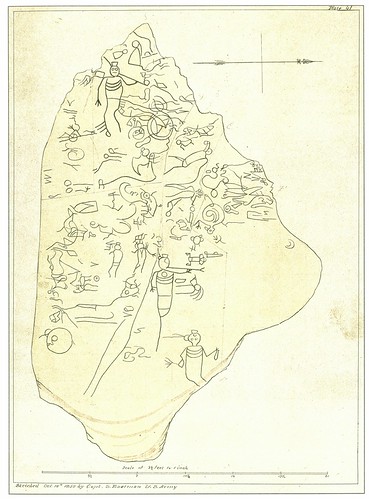
Sculptured Inscriptions on Rock, South Side Of Cunningham's Island, Lake Erie
Sculptured Inscriptions on Rock, South Side Of Cunningham's Island, Lake Erie. A pen and ink drawing (October 10, 1850) by Seth Eastman. Reproduced from Seth Eastman: A Portfolio of North American Indians (1995) by Sarah E. Boehme, Christian F. Feest, and Patricia Condon Johnston.

His record of Inscripion Rock on Kelley's Island, the original drawing for which is shown here, remains the best document that we have of this important, but now rather eroded, pictograph group.
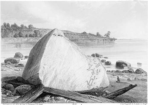
Inscription Rock, North Side of Cunningham's Is., Lake Erie
Inscription Rock, North Side of Cunningham's Is., Lake Erie. A print (1852) by Seth Eastman, from a sketch made October 12, 1850. Published in Historical and statistical information respecting the history, condition, and prospects of the Indian tribes of the United States; collected and prepared under the direction of the Bureau of Indian Affairs per act of Congress of March 3rd, 1847, Volume 2 (1852) by Henry Rowe Schoolcraft. Used courtesy of Cornell University Library and the Internet Archive.

Another boulder, now lost, inscribed with pictographs was present on the north shore of Kelley's Island, near the present state park campground.

Eastman's documentation of the island also included two earthworks.
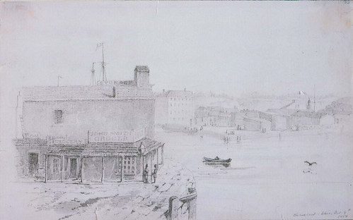
Cleveland, Ohio Grocery Store
Cleveland, Ohio Grocery Store [John Smith Grocer]. A drawing (October 9, 1850) by Seth Eastman. Used courtesy of the Museum of Fine Arts, Boston.

In the course of his travels, Seth Eastman made drawings of the cities he passed through, along with other items not relating to the subject of his research. The Museum of Fine Arts, Boston, has drawings by Eastman of Fairport Harbor and Sandusky, in addition to this one, of a grocer on the Cuyahoga River, in Cleveland.

After the initial discovery of this painting wore off, I started to suspect that the watercolor painting, Lake Erie, From Cleveland, might have been made in the 1850s, based partially on his observations in the 1830s. I couldn't locate any works this early by Seth Eastman, and the combination of factors in this painting - the portrayal of the landscape and the presence of Native Americans, among others - just seemed too good to be true.

So I did more research. I found that the layout of the harbor is consistent with Cleveland in 1833. The number and nature of buildings corresponds reasonably with Whelpley's print of a year later. And the improvements made in the 1840s are not present. Further, the technique of the painting is not as refined as Eastman's later works.

I'm confident, now, that Lake Erie, From Cleveland depicts Cleveland in July of 1833. It provides a rare glimpse into the landscape of this region as it used to be.

This watercolor is to be auctioned at Sloans and Kenyon this Sunday. Their estimate is $80,000-$150,000 - meaning that the bidding will likely start at $40,000.


* The Seth Pease 1796 map of Cleveland (see a drawing based upon said map) features a tent with a couple men situated by the mouth of the Cuyahoga River. However, this appears, to my eyes, to be merely added as a visual device, rather than an attempt to illustrate the location. For that reason, I don't count it as a painting of the city.

Correction: Janice B. Patterson, author of Cleveland's Lighthouses, pointed out to me that where I said "breakwater", I meant "pier". I corrected the two instances of this term. She noted that "There were no breakwaters in the 1830s -- they were built in the 1870s. I think what you are calling a breakwater was actually just a wooden pier, built on pilings and possibly reinforced with stones."

Tuesday, October 5, 2010

The New Cuyahoga: A Proposal to Straighten the "Crooked River"

The name Cuyahoga is said to mean "Crooked River". Yet in the 1910s, there was a proposal to straighten the river, The New Cuyahoga: River Straightening Recommendations. This document was brought to my attention by Kevin Leeson, of the Cuyahoga County Planning Commission. The book is reproduced here from a copy in their collections, with the exception of the map below, which is used courtesy of Special Collections, Cleveland State University.


Image used courtesy of the Cleveland Memory Project, Michael Schwartz Library, Cleveland State University

The publication includes this folded map. (Note: a higher resolution version, as well as other maps of the river, are available as part of the Cuyahoga River Online Exhibition.) The blue represents the current course of the river, while the red represents the proposed realignment. Why would the Committee on River and Harbor Improvement of the Cleveland Chamber of Commerce, the author, suggest this? Why would they suggest the drastic change to something that was for a long time, one of the more graphically recognizable elements of our city?

In short, commerce. The report suggests that the difficulty of navigating the river made shipping to and from Cleveland more expensive, putting the port at a commercial disadvantage. Further, it was said that the project would provide relief from the flooding of the Flats, as had happened in 1904 and 1913. It suggests that the money saved by preventing floods would cover the cost of the river realignment. The authors add that it would open part of the upper Cuyahoga to industrial development.

A 1919 report, Conservancy and the Cuyahoga continues on the same train of thought.

It's unclear why these proposals remained mere proposals. The shape of the river remains an important part of Cleveland's history - from its founding to industrial growth to now, when we're using it for recreation - it's even a part of the Cleveland Area History logo.

There's no mention as to whether they planned to change the name of the river, once it was no longer "crooked".

Thursday, August 12, 2010

Cleveland in the 1870s

Our city through the eyes of Otto Bacher

Otto Henry Bacher was born in 1856 in a house on River Street (now Old River Road) near St. Clair Avenue. He would go on to become one of the first artists to leave Cleveland and attain national prominence. Bacher began studying art in 1874. Most of the images that I will share here are from 1877 and 1878, just before he left Cleveland for Europe to further his studies.

This group, from the collections of the Cleveland Museum of Art, provide some insight into the mind of a young artist. More than that, they show how one individual perceived the city around him. We have plenty of historic photographs, illustrating the things that people found important. These drawings and etchings are different. (An etching, to clarify, is a type of print where acid is used to cut the design into a metal printing plate.) In addition to focusing on scenes that would be of interest to the viewer, Bacher also depicted scenes purely for the aesthetic merit of their compositions. As a result, we have images of things that would have been thought too minor or too insignificant to photograph.

Can these be taken as factual accounts of exactly how things were on this or that day in 1878? No, no more than a journal can be. But like a journal, they illustrate one individual's perception of the situation. The valuable analysis that Bacher provides can surely help us better understand what life was like in Cleveland in the 1870s.

This map will help illustrate the locations that Bacher's drawings and etchings depict.

Spring Street, Cleveland

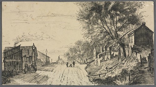
Many of Otto Bacher's Cleveland works focus on the area where he was born and grew up, close to the Cuyahoga River and Lake Erie. This drawing, Spring Street, Cleveland, (now West 10th between Front Street and St. Clair Avenue) was probably less than a block from where he grew up. It appears that Bacher was looking north on Spring Street when he made this drawing.

We can see small houses and sheds, which were probably residences, suggesting the level of poverty in the area. Clothes hang from lines on the slope to the right. There is a railing on the hillside, probably for a set of stairs going up it. Children play in the street and pedestrians walk down it, on the left. At night, the street was illuminated by the lamps, also on the left.

Bacher also made an etching of this composition, Spring Street, September 1878. The print focuses more on the general composition, with fewer specific details.

West Pier 1878

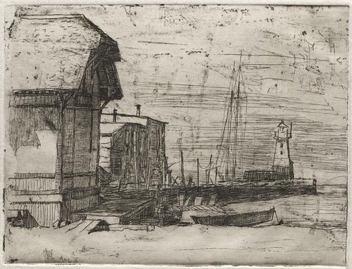
West Pier, or Government Pier, was located on the east side of the mouth of the Cuyahoga River. In the fore and midground, we can see several buildings likely associated with the activities of a port. A rowboat is also visible. In the background, the rigging and masts of a ship are present, as is a lighthouse. It's unclear as to whether the ship could have been docked in that location or if it was transiting from or to the lake. Bacher made this into a more romantic view in West Pier, Cleveland

Ship and Elevator (1878)

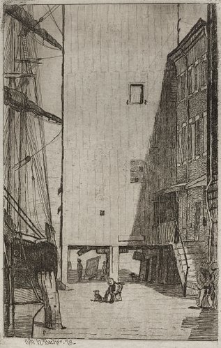
Ship and Elevator was probably a depiction of the Union Elevator (the only one that I've been able to locate on period maps) on Merwin Avenue near British Street. A ship is docked, probably while it waits to unload. In the midground, an man and a dog are seated. The buildings, probably commercial structures, were probably brick, judging by the stone lintels over the window frames. The second story entrances were either because the first floors were used for storage of goods or because of issues with flooding.

Old Passenger Depot

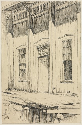
The Old Passenger Depot was located due north of Spring Street, on the edge of Lake Erie. By this time, it had been replaced by the Union Passenger Depot, just to the east. This, the old depot, had clearly been allowed to deteriorate, as seen by the condition of the boardwalk in front of it.

Cottages, Cleveland (1878)

In Cottages, Cleveland, we catch a glimpse of several tiny houses, probably along the Cuyahoga. In an effort to expand these tiny spaces, additions were built, hanging over the river. The historical record is full of photographs and prints of the houses of the upper classes, lining the avenues and boulevards, and even contains a good sampling of those populated by the middle classes. We see very little, if any, documentation of residences like these.

Street Scene, Cleveland

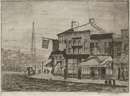
I'm guessing that Street Scene, Cleveland may have been drawn based on the northern corner of what is now Old River Road and West 10th Street. The layout of the streets is consistent, and it's the neighborhood that Otto Bacher grew up in. We can clearly see the deterioration in both the sidewalk and the street.

Downtown, Cleveland

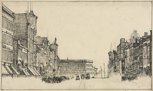
The drawing, Downtown, Cleveland appears, based on the shape of the layout of the streets, to depict Superior Avenue, looking west from Public Square. We can see a trolly or streetcar and the tracks that it travels. The bustle of commerce is obvious, though the exact activities are unclear.

The Square (1878)
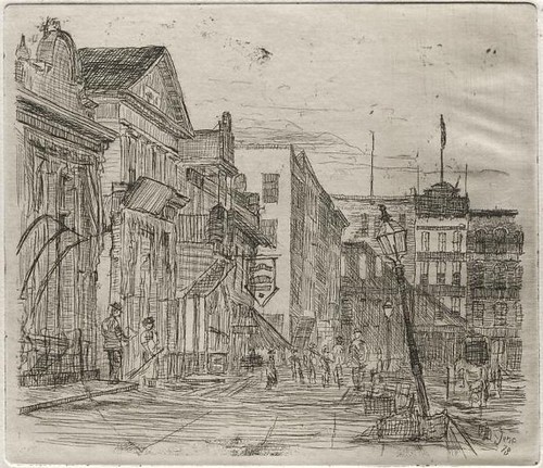
The Square, an etching, illustrates the southwest corner of Public Square. Pedestrians walk along the sidewalk, and a horse and carriage may be seen on the roadway. A streetlight has suffered some sort of damage and leans at an angle. If my interpretation of the angle is correct, the building with the light colored side shuold be city hall.

Cleveland, Woodland Avenue and Eagle Street (1878)

The etching Cleveland, Woodland Avenue and Eagle Street reveals, in the distance, one architectural element still present today - the tower of Old Stone Church. Though it may be dwarfed by skyscrapers today, it's important to realize the way the church towers must have been visible over much of the area. This view, looking approximately north northwest, shows an area that is now Jacobs Field. One business, with the awning opened, may be a pawn shop, based on the three balls hanging from the front of the building.

Tower of the Chimes, Old Trinity, Cleveland

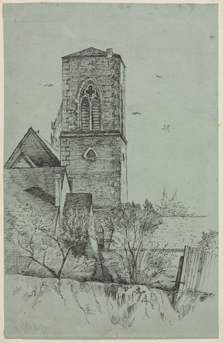
Tower of the Chimes, Old Trinity, Cleveland depicts the tower of the Episcopal church, on the south side of Superior Avenue, just east of where the Arcade now stands - just west of East 6th Street. The most interesting part, to my eyes, is the unevenness of the land, which has now been completely flattened.

An Old House, Cleveland

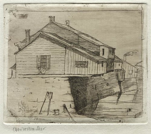
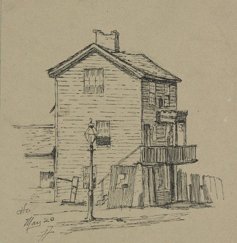
We don't have enough information to identify the source for the composition, An Old House, Cleveland. One might guess, based on the slight slope revealed by the fence on the right, that it might have been somewhere on along the edge of the Cuyahoga valley, probably in the neighborood that Bacher was so familar with. As for the age, we have few clues. The number and size of panes in the double hung windows, 8 over 8 on the upper window on the side, and either 9 over 9 or 12 over 12 on the front, suggest an earlier structure - perhaps the first third of the 19th century. The pitch of the roof, the only other significant element that we have to work with, would be consistent with this, though it could also reasonably have been as late as 1840 or 1850 - but I doubt a house would have been considered "old" thirty years after its construction. The chimney shows deterioration, as does the fence.


These are but some of the images that Otto Bacher created as a young man of his hometown - more do exist. His perspective reveals many details of this time that we simply don't see elsewhere. What do you see in his drawings and prints?

Thursday, January 14, 2010

The History of the Veterans Memorial Bridge


Image courtesy of the Cleveland Memory Project Poscard Collection

I confess I was a bit skeptical when Bill Barrow offered me a review copy of William E. Beyer's The History of the Veterans Memorial Bridge: 90th Anniversary Edition. "How can there possibly be 600 pages worth of material on the Detroit-Superior Bridge that anyone would be interested in reading," I asked myself. Further, I thought, "how the heck will I slog through it?" I quickly learned that my fears were unfounded. The 600+ page, 3.5 pound tome is mostly pictures - "profusely illustrated" is the polite term, I think.

William E. Beyer became interested in the history of the bridge while working as project manager for Howard, Needles, Tamen & Bergendorf on its 1995-1996 rehabilitation. He assembled a massive weath of information which was originally distributed in 2001, in a very limited edition, run off on the office laser printer. This reprint is on nice, heavy, glossy stock, with a sewn hardcover binding.

Rather than a book, imagine The History of the Veterans Memorial Bridge as an impressive, well documented archival collection. All of the photographs that you might find in an archive, all the historical documents, everything. Further, it's explained by someone who clearly knows the subject.

Byers begins by documenting the need for a high level bridge, describing the frequent traffic jams and malfuntions suffered by the old Superior viaduct. He goes on to describe the purchase of the real estate, the bidding of the contracts, and more. In addition to photographs, the illustrations include many editorial cartoons depicting the political battles surrounding the construction of the bridge.

When we get to the actual construction of the bridge, it becomes quite obvious that Byer is an engineer. The discussion becomes quite technical in nature, though still readable to the layperson, for the most part. The photographs of the actual construction are impressive. They show, in exhaustive detail, the work on the bridge. Each and every step in the building process is docuemented in detail.

Byer continues, providing photographs of the use of the bridge by automobiles, streetcars, and pedestrians. Streetcars ran on a second level, underneath the bridge. The construction and design of this and the approaches are documented fully. Readers will also be interested to see in the photographs various buildings in the flats and at the ends of the bridge that are no longer present.

In the 1950s, streetcars lines under the bridge were shut down. A feasability study was conducted to determine whether cars could run on the lower level. It was determined that they could not, and the access wells on each end of the bridge were filled in.

The documentation includes the two major rehabilitations of the bridge, in 1967-1970 and 1995-1997. That the damage was allowed to get as far as it did is concerning at times. It is impressive to see how it all went back together.

Byer also provides brief biographies of some of the engineers on the building of the bridge and some of the involved a companies. A massive fold-out technical drawing of the bridge is also included. Appendices contain bridge contracts, bid quantities and prices for the original construction, both rehabilitations, and the 2004 promenade. Additional appendices contain correspondence relating to the bridge, sample design calculations, and some basic computations of the geometry and stresses on the bridge. Beyer finishes the book with an exhaustive bibliography.

This is not simply a book for the bridge nut. It's one of the better photographic collections that I've come across dealing with the history of the area. It's priced right, too, at $40, shipped. While that isn't exactly cheap, for a 600 page book of photographs, it's a good deal. You can fill out the order form and mail it in or save $10 by picking it up in person at the Cleveland State University Michael Schwartz Library.

Saturday, December 26, 2009

The floods of 1913 in the Flats

Third Street Bridge and the steamer William Henry Mack

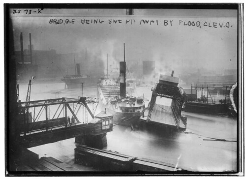
I came across this photo in the American Memory Collection at the Library of Congress. It depicts the steamer William Henry Mack and the West Third Street Bridge, in the Flats, in March, 1913. Much of the midwest suffered the effects of flooding during the spring of 1913. The high waters caused the William Henry Mack to break free of its moorings and crash into the bridge. According to The Lightship, volume 24, issue 4, the March 25 accident caused $20,000 of damage to the ship and demolished the bridge.

The swing bridge is on the site of the present West Third Street Bridge. The photographer was looking approximately due east. One of the boxcars in the foreground is or was made to carry automobiles for the Baltimore and Ohio Railroad.

The article about the William Henry Mack (later the Valcartier), on page 7 of The Lightship, is really worth checking out. It provides a full history of the ship, which was built in 1903 by the American Shipbuilding Co.