Tuesday, April 3, 2012

Hiding on the Near West Side

Over the weekend, I was driving around the near west side of Cleveland. My purpose was twofold. I needed to keep the kids entertained (our visit to the art museum had lasted but 45 minutes) and I wanted to check out a house, said to have been built in 1865, owned by someone that I went to high school with. Said house is undergoing a full-gut rehab, and I was hoping, if the date was indeed 1865, to be able to better document construction techniques.

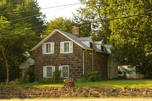
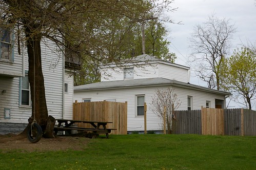
3012 Barber Avenue (rear)
Then, I came across this house, peeking out from behind another, at 3012 Barber Avenue. Based on the style, it seems to have been built around 1840-1850. A better look reveals a bit of detail, but not much – it’s all hidden underneath vinyl siding.
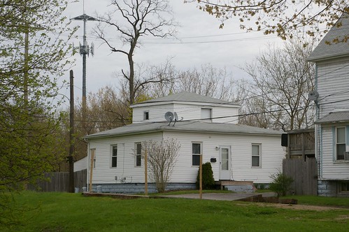
3012 Barber Avenue (rear)
The foundation appears to be made from rusticated concrete blocks, which replaced the original stone blocks. This means either that it was moved at some point or that something happened (deterioration of the original foundation, for instance) that made it require a new foundation.

This house is of a style not often seen in greater Cleveland – and for that reason, it’s especially interesting. The I.T. Frary photograph collection at the Ohio Historical Society contains a couple similar structures.
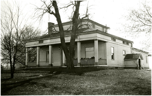
House, North of Wellington, Ohio. 1923.
House, North of Wellington, Ohio. 1923. Print 1755, a photograph by I.T. Frary, in the collections of the Ohio Historical Society. [19566 State Route 58, Wellington, OH.]
This one features a front porch. The house on Barber Avenue might have had one – it’s impossible to know without getting inside the structure. (Note that the front windows on this house appear to have been replaced with much wider ones than would have been original, likely in the early 20th century.)
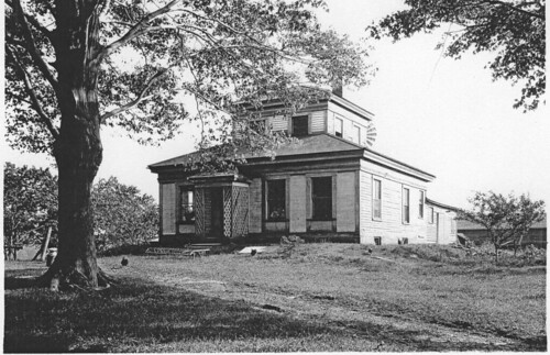
2612 - House
2612 - House. Between Shalersville and Freedom, Ohio. 1926. A photograph by I.T. Frary. Scanned from a photocopy of an original in the I.T. Frary Audiovisual Collection at the Ohio Historical Society.
Another, seen here, lacks a porch, but instead has a small awning, which is likely original. The lattice work on it, however, is not. Such awnings were often lost, as they, like all porches, tend to deteriorate more quickly than the rest of the houses that they are attached to. One would have to remove the vinyl siding on the house on Barber to determine if such an awning existed originally.

To get a better idea as to just how old the house might be, I turned to the 1881 Atlas of Cleveland, Ohio.
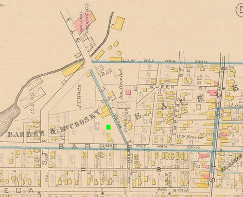
Plate 19, 1881 Atlas of Cleveland, Ohio
Detail of Plate 19, 1881 Atlas of Cleveland, Ohio. Used courtesy of Cleveland Public Library.
The house should be approximately where the bright green box is – but there’s nothing there. Further, there aren’t any other obviously square houses nearby that might have been moved here.


View Larger Map
To better illustrate the landscape, here’s a map showing the same approximate area now.

Where was this house moved from? What other stories does it tell? They’re worth investigating – especially if said investigation involves historic photos or removal of the existing vinyl siding.

Tuesday, March 27, 2012

Wade Park and the Layout of University Circle

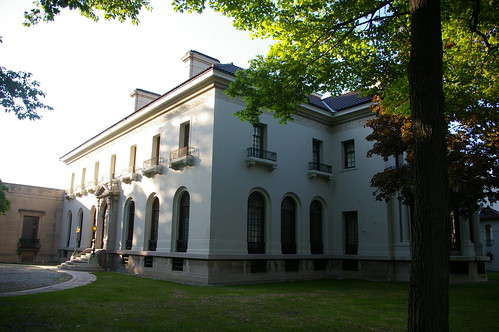
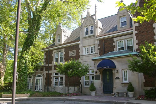
Glidden House
Glidden House (built 1909). 1901 Ford Drive.

When I look at the buildings that make up the area we now call University Circle, I tend to assume that the area was laid out and built in the 1900s and 1910s. Indeed, save for some buildings on the campus of Case Western Reserve University, there aren't any structures built much before this time.

Western Reserve Historical Society

The houses that haven't been replaced by newer buildings tend toward grand mansions - like the Hay-McKinney House - one of the structures occupied by the Western Reserve Historical Society.

IMGP2409 Hawken School

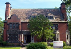
Even the (relatively) smaller houses, like this pair on Magnolia Drive, seem quite suited to the flow of the boulevards.

Imagine my surprise when I learned that a good portion of the roads we use today were laid out a good 30 years before these houses were built.

Ward 17 north
Ward 17 south
Details of the 1874 D.J. Lake Atlas of Cuyahoga County, Ohio, used courtesy of Cleveland Public Library.

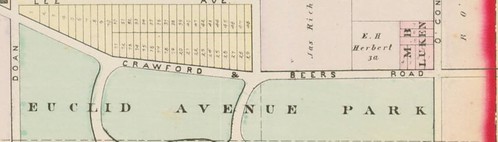
Jeptha Wade began developing his farm into a park (Wade Park) in the early 1870s. These details show the layout of the roads within the park as they were in 1874. The map is bounded by Euclid Avenue on the south, East 105th Street on the west, East 115th Street on the east, and Ashbury Avenue on the north. Note how similar the layout of these roads remain to the streets present in the University Circle area today. Perhaps they're part of the reason why the area has managed to retain something of a park-like presence.

Wednesday, March 14, 2012

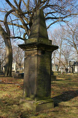
The Edwards Family Obelisk

Edwards
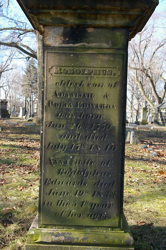
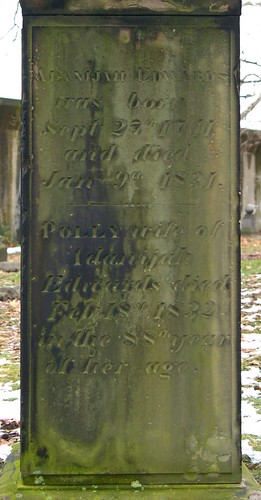
For a while, I've wondered about this grave marker in East Cleveland Township Cemetery. It appears to have been made in the 1830s or 1840s. The style is one that I've occasionally seen in advertisements from the period, but rarely in person.

It marks the graves of several members of the Edwards family:

Edwards Edwards Edwards, Adanijah and Polly

Rodolphus Edwards, Jr. house
Rudolphus is best known as a surveyor for the Connecticut Land Company. He later had a tavern on Woodhill Road at Buckeye. His son, Rudolphus, Jr., built this house at 10701 Buckeye Road, in about 1840. I covered it in some detail a while back - and hope to provide some additional coverage in the near future.


? [Edwards family plot]
The Edwards family plot at East Cleveland Township Cemetery also includes two more traditional markers. One, I cannot read - it appears to date from between about 1820-1840.

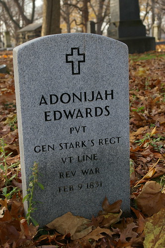
Edwards, Adonijah
The other is a recent marker, for Revolutionary War veteran Adonijah Edwards.


Why does this bug me so? The marker appears to date a couple decades before the cemetery opened, and is in rather good condition for the age. Further, it's of a style that I don't usually see around here. There's clearly a story - but what? Finally, Wickham (Pioneer Families of Cleveland, p. 37-38) provides the answer.
All the members of the Edwards family who died in Cleveland were buried in a small cemetery in the rear of the old Congregational church, north-west corner of Euclid Avenue and Doan [now East 105th] Street. It was then called the East Cleveland burying-ground. The entrance was from Doan Street. The largest and the finest monument in it, and, eventually, the last one, was that of the Edwards family, and, finally, when all the bodies had been removed from the cemetery, this, with other Edwards grave-stones, remained standing until the old church was razed. A big bank building stands on the site of the little church, and part of the cemetery is covered by another towering edifice.

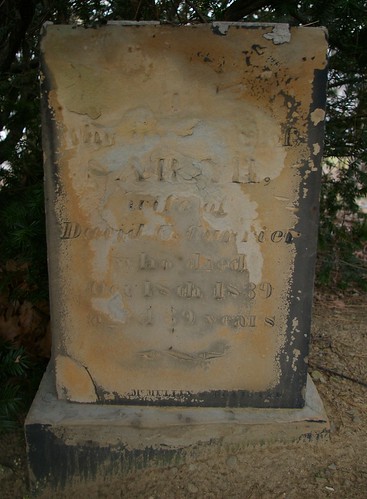
Currier, Sarah
But one similar marker comes to mind in the area - that of Sarah Currier, in First Presbyterian Churchyard, in East Cleveland.

Currier, Sarah [top of marker]
It isn't as grand - it lacks the obelisk of the Edwards marker - and further, the capital, shown here, was knocked off at some point.
The Edwards marker remains a grand monument to the family. Try to imagine it in a little cemetery at the northwest corner of Euclid and East 105th Street.

Wednesday, March 7, 2012

From Early House to Milk House

I’ve been working on editing a history of the Parks family, who came to the Collinwood neighborhood of Cleveland in 1834. It’s a wonderful manuscript - full of all sorts of personal details and anecdotes that you simply don’t find in most family histories.


View Parks property in a larger map

The Parks family farm, purchased in 1834, is indicated in this map in blue. It is bounded on the east by East 140th Street, on the south by Kuhlman Avenue, on the west by a diagonal that continues from the end of Eaglesmere to the lake shore, and on the north by Lake Erie. The farm, all told, was about 200 acres.

There’s a passage in the manuscript that really caught my attention.
They found later that the previous owner, a Colonel [John] Gardner and his family had nearly died there of chills and fever. Grandfather held the view, then common, that the disease was caused by a miasma that rose from the water and earth after nightfall and for many years the children were carefully herded into the house as it grew dusk. Anyhow, none of the family ever had a touch of it.
Perhaps that was because Grandfather's first act was to dog a big ditch right through the farm to the Lake; next he built a new house. The little old one was always used for a milk house.
The milk house is noted by the jug of milk in the map above - right next to the site of the 1834 house.

I was a bit skeptical as to Gardner’s involvement with the property. I hadn’t heard accounts of property being rented - but research shows that it was not uncommon. In fact, evidence points to some very good reasons why John Gardner might have built the small, likely one-room house for his family on this piece of property rented from Henry Coit.


Achsa Sherwin was born December 28, 1789, in Winchenden, Massachusetts, the fifth of Ahimaz and Hannah Swan Sherwin’s ten children. She married John Gardner (born about 1789) on October 30, 1808, in Hartland, Vermont.

A decade after her marriage, Achsa’s parents moved to Cleveland. The account is described in Wickham’s Pioneer Families of Cleveland (p. 200-201).
On the morning of a bitter winter day in February, 1818, a large sleigh drawn by two farm horses moved briskly in a south-western direction from Middlebury, Vermont, a town but a few miles east of the New York state line, and about half-way between lakes Champlain and George.
The seat of this sleigh was occupied by Ahimaz Sherwin, Jr., 26 years of age, his young wife Hannah Swan Sherwin, and their little daughter Lucy but a few months old. The back of the sleigh was piled high with household furniture, bedding, and clothing. The family had started in mid-winter on a ride of 500 miles, at least half of which led through a trackless wilderness. But, aside from the weather, traveling at this time of year was far easier than through the summer months. A sleigh moved over the snow more smoothly and with less jolting than a wagon, also over ice-bound lakes and rivers that otherwise would have to be forded or avoided. The sleighing was excellent all the way, but the weather very severe; the thermometer for ten days of the trip was below zero. Their food and shelter for the night was ever uncertain, and a source of anxiety, for it depended upon little country taverns, or upon the hospitality of isolated farm-houses. It is ever a mystery to the woman of today how a mother managed to care for a babe and keep it warm on such a long, cold journey. The case of little Lucy Sherwin was not exceptional. Hundreds of very young children accompanied their parents to the wilds of Ohio when the journey was undertaken in the winter or early spring with the frost yet in the air, and snow still covering the ground. Furthermore, instances have been given where the pioneer party waited for an expected addition of a little stranger in a family, and then started on a trip two weeks after its arrival.
The Sherwins made the distance between Buffalo and Dunkirk on the frozen shores of Lake Erie, and, early in the evening of one day, their sleigh broke through the ice, thoroughly drenching its occupants. With their clothes frozen upon them, they had to continue their journey until a place was reached in which they could spend the night. The deep-seated cold that resulted from this mishap eventually undermined the constitution of the intrepid wife and mother, and although she lived several years after reaching Cleveland she never was again well, and died leaving three young children.
The journey ended March 1st - 18 days from the time it was started. No accommodation for them and their horses could be secured in the small village of Cleveland, and they had to turn around again and go back as far as Job Doan's tavern at Doan's Corners.
Luckily for Mr. Sherwin, Richard Blinn had begun to build a new house on his farm south of Doan's Corners, and on the road to Newburgh. He hired Mr. Sherwin to do the carpenter work on it, the Sherwins, meanwhile, living with the Blinn family. By the last of August, the house was finished, and the wages due Mr. Sherwin enabled him to return to Vermont and bring on his parents to share his pioneer home.
Within a year or two, Achsa and John Gardner followed them west. (One of their children, Nelson Harvey Gardner, was born October 21, 1816, in Hartland, Vermont, fixing their residence in that place. By the time of the 1820 US Census, they were living in Cleveland.)

Gardner didn’t own any real estate in Cleveland until 1828, indicating that he either rented or lived with family or friends prior to that date, when he made a purchase on Seneca Street in downtown Cleveland (Cuyahoga County Recorder, AFN: 182812270001). He did not occupy the property immediately, as his family is still listed in Euclid Township in the 1830 US Census.

The Gardner family lived in this location while John Gardner operated a store on the east corner of Euclid Avenue and Noble Road.

Historic advertisements, included in Annals of Cleveland help illuminate the nature of the store and the sorts of things one would be able to buy in a village like this in the 1820s. They also help to show what sorts of things the residents of this area needed (or wanted).
June 4, 1824; adv:3/4 - John Gardner, has just opened a store in the town of Euclid, in the building formerly occupied as a store by E. Murray, Esq., deceased, consisting of a small but well assorted collection of Dry Goods, Groceries, and Hardware, which he will sell at reduced prices, for cash or approved country Produce.
Sept. 10, 1824; adv: 5/4 - Euclid Store. The subscriber has just received from two miles beyond the Eastward, a small but handsome assortment of Dry Goods, consisting of almost every article used in families, together with a good assortment of Groceries, of the first rate, and warranted. Also Codfish, Mackina Trout, of superior quality, Iron, Steel, Nails, Window Glass, 8 by 10 and 7 by 9, Soal and Upper Leather, Morocco Skins, With a variety of other articles, too numerous to mention - which will be exchanged for most kinds of Produce. Ashes will be taken in payment, if delivered at the ashery formerly occupied by Seth Doan, Esq. J. Gardner.
Dec. 9, 1825 ; adv: 3/5 - Euclid Store. J. Gardner. Has just received, and keeps constantly on hand, a general assortment of New Goods, consisting of Broadcloths, Cassimeres, Satinetts, Bombazetts, Calicoes, Chintzes, Cambrics, Plain and Figured Linos, Boot Muslins, Silk, Crapes, Velvets, Cotton and Worsted Vestings, Ratinetts, Salisbury & Plain Flannels, Silk and Cotton Flag Handkerchiefs, Tartan and Caroline Plaids, Cotton Ginghams and Checks, Cotton cloths, Cotton Yarn and Candlewicking, Men's coarse Boots and Shoes, School Books of all sort, New York Hats, Groceries, Crockery, Glass & Hardware, Iron. English Blister'd & Cast Steel, Drugs and Medicine, Paints and Dye·Stuffs, and other articles too numerous to mention. All the above articles are warranted to be of the first quality. He also pledges himself to sell as cheap as can be purchased in the country. Gentlemen and Ladies are requested to call and examine for themselves. Most kinds of Produce taken in payment. N. B. He also wishes to purchase a quantity of Black Salts, for part cash will be paid. Likewise, a quantity of dried Deerskins.
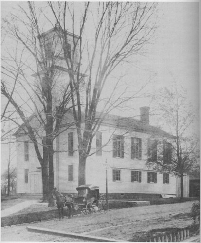
First Presbyterian Church
From Spiritual Pioneers; The Life & Times of First Presbyterian Church of East Cleveland, Ohio by Melinda Ule-Grohol, page 194.
Nov. 5, 1829; adv: 3/5 - For Rent. The subscriber offers for rent his Store and Store House in Euclid Township, a few rods west of the Presbyterian meeting house; he has built an addition to his Store, which makes it very large and convenient for a country Store. It is situated in a pleasant country for mercantile business which he will rent very reasonable; apply to the subscriber on the premises. John Gardner, Euclid.
It’s unclear when Gardner’s store closed. The establishment reopened in 1830.
Nov. 11, 1830; adv:3/3 - Euclid New Store. New Goods at the lowest Cleaveland prices. H. Foote & Co. Have just opened a new store at the stand known as the Gardner store in the Town of Euclid where they have for sale a first rate assortment of Dry Goods, Groceries, Hardware, and Crockery.
Within a couple years, Gardner opened a similar business in Cleveland.

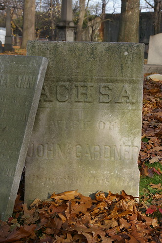
Gardner, Achsa

Achsa Sherwin Gardner died in 1847, and was buried in East Cleveland Township Cemetery.


All six members of the Gardner family lived in what was likely a one-room house - on later maps, it shows up as less than half the size of the house with two rooms on each floor built by Sheldon Parks. From these cramped quarters, John Gardner travelled two and half miles each day to his store.

This is telling of the conditions endured by the early settlers to the region. It also illustrates that a path between the location on Euclid Avenue and the Parks farm was present at the time that they moved here, in 1834, providing a connection between their farm and the village.

Wednesday, February 15, 2012

The Thorp - Page Sawmill

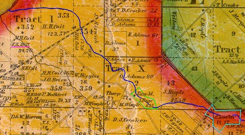
Detail, East Cleveland Township
A detail from the 1858 Hopkins Map of Cuyahoga County. Used courtesy of Rails and Trails, original courtesy of the Bedford Historical Society. Annotations by the author.
In 1837, two farmers, both residents of Cleveland, purchased a small, oddly shaped parcel of land (Cuyahoga County Recorder, AFN: 183904200003). The $250 purchase netted them 8.27 acres, with Coit Road on one side, and Nine Mile Creek running down the middle of it. The property, outlined here in green, was about a quarter mile south of St. Clair Avenue.

The Luster Tannery
You may recall Nine Mile Creek as the source of water for the Luster Tannery (16360 Euclid Avenue, East Cleveland), about a mile upstream. The structure, built for tanning leather in the 1850s, is a major early industrial landmark. The Luster property is outlined in light blue

The two men who purchased the land, Cornelius Thorp and Isaac Page, both lived in the area. Cornelius, at the time, was 30 years old, and was married, with three or four children. Isaac was a few years older, also married and the father of at least a couple children.

Both had farms of a decent size - Isaac Page's amounted to 62 acres, while Cornelius Thorp's farm was about 40 acres.

Why, then, did they purchase the land?

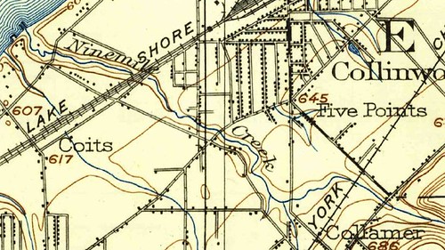
Detail, 1903 USGS Topographic Map
This detail of a 1903 USGS topographical map, covering about the same area as the one used to open this story, helps illustrate why. Note that Nine Mile Creek seems to enter a ravine at about the point where the sawmill is located (to the left of the "k" in "Creek"). Perhaps there was even a falls. Whatever the case, there would probably have been significant water power at the site.

Water power was very important in the early to mid 19th cenutry - other than steam engines and manual labor, it was the only way one could power anything. Even on a tiny creek, a small dam could store up enough water to power a mill for a couple hours a day.

To take advantage of the water power, a sawmill was built on the site, as illustrated in the 1858 map that I lead with. When was it built? I haven't been able to locate any information relating to that. One might suspect that construction began soon after the purchase, unless they bought the land speculatively.

Thorp and Page probably operated the mill part-time - the 1850 and 1860 U.S. Censuses list their occupations as "farmer". It was quite common at the time to do other work to supplement farm income, so this does not seem strange. However, as of 1860, Isaac's son, Isaac Morris (or Maurice) Page lists his occupation as "sawmill" - perhaps running the business full time. A decade later, however, he is listed again as a farmer.

There is only one other sawmill pictured in East Cleveland township on the 1858 Hopkins map - a steam driven one on Shaw Brook, operated by Henry Coit, shown in the far left of the detail above. This suggests relatively little competition in the immediate area.

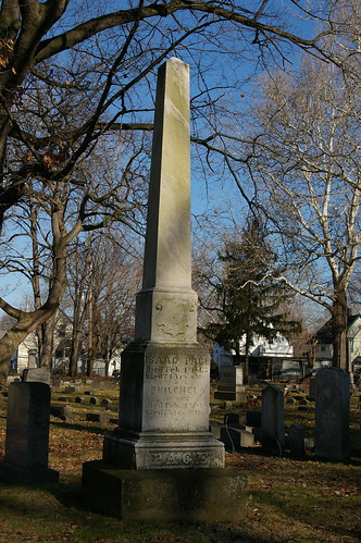
Page
The grave of Isaac Page (the father) is marked by this obelisk, in East Cleveland Township Cemetery.

Thorp
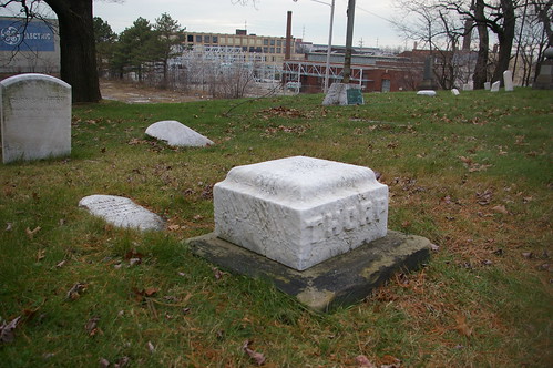
A small obelisk, mostly buried, marks the Thorp family plot at First Presbyterian Churchyard, in East Cleveland.

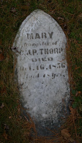
Thorp, Mary
The only name visible is that of Cornelius's daughter, Mary. It'll be worth digging up the fallen obelisk and replacing it on its mount, to see if the names of other family members are noted.

These weren't the only mills in the immediate area - there were more in Euclid, as detailed in Mills & Salt, on Bluestone Heights. Still, this example represents an interesting piece of our early industrial history.