Showing posts with label Carnegie Avenue. Show all posts

Wednesday, April 6, 2011

Identifying Your Photographs: A New Series


Photo by The Heiser Co., Commercial Photographers, Cleveland.

This is the first post in a new series, Identifying Your Photographs. In it, I'll take your unidentified historic photographs of the greater Cleveland area and try to determine where they were taken. The posts will include illustrative details on the subjects, and, when possible, photographs of the scenes as they are today. In addition, I will explain how I was able to identify the locations, so that you might be better able to look at the historic photos in your own collection.


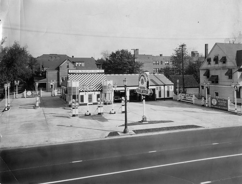
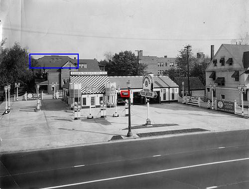
This photograph, posted on Flickr by a friend, was a challenge. It is of a gleaming new Cities Service (now CITGO) gas station. The images was likely made in the early 1920s, based on the cars in the garage and the years Cities Service Oil operated.

The service station has eight gasoline pumps and four air compressors for vehicle tires. It features six service bays, at least two of which were use at the time of this photograph. A neon sign, advertising Cities Service Oils' brand, Koolmotor gasoline, stands in front of the structure.

The bricks that made up the structure were glazed, most likely white in color, with a band of darker bricks at ground level. The roof appears to be made of stamped enameled steel - similar in composition to what might be used on the exterior of a stove or washing machine. Flanking the main door are two towers with display windows. The towers appear flimsy, in comparison with the rest of the station. Close examination reveals that the upper part of the windows was just painted on.

The station was likely a corporate design, one of many similar structures. It bears much similarity to one featured in this entry, in the Encyclopedia of Oklahoma History and Culture. Note that the towers in that photo appear to be more substantial, with glass in the upper parts of their windows.
Standard Oil Co. gas station

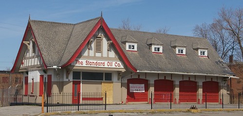
The pitch of the roof, the proportions, and some other style elements, namely the cast-iron gutter heads, bear some resemblence to the Tudor-style houses built at the time. It bears some similarity to a group of structures with stronger Tudor elements built in the Cleveland area by Standard Oil. This one, on Euclid Avenue in East Cleveland is among them.
Cities Service Oil Co.

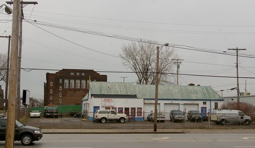
This is the gas station as it stands today, at 8201 Carnegie Avenue, in Cleveland, Ohio. I was unable to obtain the same perspective as the original photographer, who either used a ladder or a perch on a building on the other side of the street - this is as close as I was able to get.

Much of the basic form of the building remains. An addition to the front provides a bit more office space, at the loss of the towers, which, as noted above, seemed a bit flimsy. It retains the basic configuration of service bays, and of most of the window and door openings. Even the small awning over the side door remains. The enamel steel roof is still present, an indicator of the durability of the material. This gas station is a testament to the adaptability of commercial structures, especially when keeping up with the latest style isn't a concern.

This is not to say that much hasn't been lost, too. The cast iron lights that illuminated the gas station at light are long gone, as are the sconces in a complementary style on the outside of the building. The orginal gutters and cast iron gutter heads are gone from the front of the structure, but appear to remain, at least in part, on the side of the building.

The houses, both on the side street and to the right of the station are no longer present. Nor is the three story brick building, probably apartments, seen to the right and rear.

How Did I Identify It?

First, I looked at the Historic Plain Dealer, 1945-1991, a great database that I detailed back in December. Note: a Cleveland Public Library card is required for access. I looked for Cities Service ads, with the hope that they would list the locations of their gas stations. While I found plenty of their ads, they did not include any addresses. The old city directories in the History and Geography Department at Cleveland Public Library would likely include the addresses for the service stations. If it wasn't the 30th time you've contacted them this month, a brief call (216-623-2864) would probably get you a list of their addresses. However, I'm stubborn and have to look things up for myself.

Next, I looked to see what other information might possibly be contained in the photograph. The most obvious is the angle of the sun, which tells us that the building isn't on the south side of the street.
untitled photo
Photo by The Heiser Co., Commercial Photographers, Cleveland. Annotations by the author.

The photograph was, thankfully, scanned at a very high resolution. This revealed much detail, and made identification of the building possible. In the center of the image, on a street light, there is a sign, "Carnegie", outlined here in red. This meant that I was looking for a structure on the north side of Carnegie. After using Bing Maps "birdseye" imagery to browse the area from downtown to about East 70th Street, I was reasonably convinced that the building was gone.

I took a new look at the image, this time not looking for identifying characteristics of the gas station, but for other landmarks that might help me figure out where it had been sited. The houses, while of good quality, didn't possess any special characteristics that would make them stand out. The building in the background, to the left, outlined in blue, however - it had a unique shape - one I initially assumed to be a theater.

After a bit more browsing, the shape became familiar. It was the rear portion of the Euclid Avenue Temple (now Liberty Hill Baptist Church), at 8206 Euclid Avenue. With this information, locating the spot on Carnegie was easy. Much to my surprise, the station was still standing. It's an interesting structure, one I would have thought I would have paid more notice.

Do you have a photograph that you would like to have researched and included in this series?

Get the best quality scan that you can still email - note that the crucial information here was pulled from tiny details - and send it to ClevelandAreaHistory@gmail.com. If you don't have access to a scanner, you can mail me your original photograph, well-protected and at your own risk, with a self-addressed stamped envelope for its return, and I'll scan it.

I look forward to identifying your Cleveland area photographic mysteries.

Tuesday, August 10, 2010

Cleveland in 1927, part 4

I recently obtained ten 4x5 glass plate negatives of Cleveland scenes, taken in 1927. Thanks to the assistance of Bill Barrow, Special Collections Librarian at Cleveland State University and Joanne Cornelius in the Digital Production Unit there I was able to get the negatives digitized at 1200 dpi. This provides a very high resolution look at these parts of Cleveland. Be sure to click through for the highest resolution versions of the files.

In the first post in this series, I shared a few scenes that were reasonably familiar - the Terminal Tower, the Arcade, and Public Auditorium. In the second post, I shared two views of Central Avenue (now Carnegie Avenue) at East 14th Street. In post three, I continued the journey west on Central Avenue. In this, the last post in the series, I share two more view of Central Avenue as well as one that provides a fitting close.

Central Avenue at Woodland Avenue, looking west

For this image, the photographer was looking southwest on Central Avenue (now Carnegie Avenue). In the foreground, to the right, is the intersection with Woodland Avenue. In the midground, Broadway Avenue crosses Central. In the background, Ontario Street intersects with Central. In the version of this image on Flickr, I've noted all these items.

Here we see, on the left, the building with the large awning, seen on the right in the last photograph of the last post. Behind it is the ornate Broadway Hotel, advertising steam heat and rooms at 50 cents, 75 cents, and $1.00.

Behind the Broadway Hotel, we can see several billboards. One advertises Cleveland Wallpaper Cleaner. Another, for a Studebaker, lists the price as $1335. A third is for Lucky Strike cigarettes.

In the background, at Ontario Street, we see an interesting almost-triangular building, which was demolished to make way for the Lorain-Carnegie Bridge.

On the right side of the street, at Woodland Avenue, stands the OK Hotel, advertising beds for 25, 30, and 35 cents. The sign noted that they had free shower baths. Note the building behind it that is three pairs of windows wide.

Central and Ontario (looking northeast)

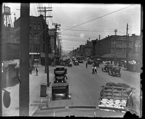
In this photo, the building that is three pairs of windows wide, as noted above, is seen, from the opposite side. Here, the photographer is looking northeast down Central Avenue. Ontario Street intersects with Central in front of the aforementioned building. Behind it, Broadway Avenue intersects with Central. We can see a sign on the building advertising "the greatest Buick ever."

On the right side of the street, a billboard for the Cleveland Trust notes that it finances "Paint and Varnish, Cleveland's Leading Industries." What else can you see here?

Cleveland, as seen from the Gold Coast

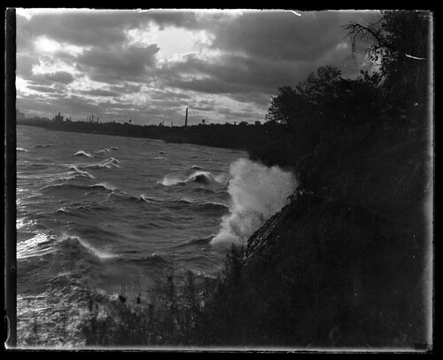
At first, I had assumed that this was another unidentifiable view of Lake Erie. However, the presence of the Detroit-Superior Bridge in the distance (at the far left) helps show us exactly where the photographer was standing - on the Gold Goast, looking east at downtown Cleveland.


This view, probably at sunset, provides a fitting (if slightly cliché) end to this series. I hope to share other previously unseen sets of historic photographs of Cleveland in the near future, but I need your help - I can't afford to keep buying these photographs just for the sake of providing new and interesting content.

If you have such a set of historic photos of the Cleveland area, and are willing to share them, please contact clevelandareahistory@gmail.com. I will scan them and return the originals. I'm not just interested in pictures of buildings - photos of people and of daily life are great, especially if the individuals in the photographs are identified. Your loan of the materials will help better illustrate our local history.

Wednesday, August 4, 2010

Cleveland in 1927, part 3

I recently obtained ten 4x5 glass plate negatives of Cleveland scenes, taken in 1927. Thanks to the assistance of Bill Barrow, Special Collections Librarian at Cleveland State University and the Digital Production Unit there I was able to get the negatives digitized at 1200 dpi. This provides a very high resolution look at these parts of Cleveland.

In the first post in this series, I shared a few scenes that were reasonably familiar - the Terminal Tower, the Arcade, and Public Auditorium. In the second post, I shared two views of Central Avenue (now Carnegie Avenue) at East 14th Street. In this post, we will continue southeast, looking at an area that have been completely changed by the interstate highway system and the construction of Jacobs Field.

Central Avenue, looking northeast

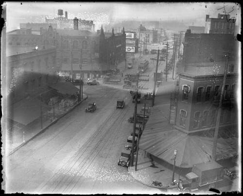
It took me a long time to figure out where this photograph was taken. Unlike the other photographs, there weren't any obvious street signs or named buildings that are still extant. Finally, I saw two buildings in the distance that I knew - the YMCA and the Walker and Weeks building. Between the two, in the haze, one can also make out the outline of a church. From this, I was able to see that the photograph was also taken of Carnegie Avenue (at the time Central Avenue).

The photographer appears to have been on the top of a building, on the north side of Carnegie, at about East 7th Street. In the distance, the water tower and smokestacks of the Independent Towel Company are visible. Near the right side of the image, a square tower with four small domes is Acme Hall. The Hall faced East 9th Street, the intersection of which is visible in the midground.

A poster in the alley advertises a film of the fight between Jack Dempsey and Gene Tunney. On the right side of the street, underneath a billboard for Meadow Butter is the Sencabaugh Company, a grocery wholesaler.

Central Avenue, at Broadway, looking northeast

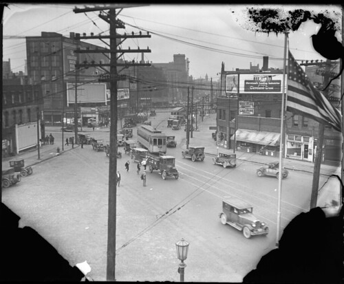
This view, still looking northeast, shows the intersection with Broadway. As a point of reference, the tower of Acme Hall is visible just behind the traffic light, in the middle of the intersection. The water tower of the coffee company that was visible in the second post can be seen here, from the opposite side. Finally, the Botzum Bros. sign that was visible in the previous photograph can just be seen above the far end of the streetcar. Note the interesting truck on the right, on Broadway, just about to pull onto (or cross) Central.

Friday, July 30, 2010

Cleveland in 1927, part 2

East 14th Street and Carnegie

I recently obtained ten 4x5 glass plate negatives of Cleveland scenes, taken in 1927. Thanks to the assistance of Bill Barrow, Special Collections Librarian at Cleveland State University and the Digital Production Unit there I was able to get the negatives digitized at 1200 dpi. This provides a very high resolution look at these parts of Cleveland.

In the first post in this series, I shared a few scenes that were reasonably familiar - the Terminal Tower, the Arcade, and Public Auditorium. This photo is the last one that will contain many obviously recognizable buildings.

The scene shown here is of the intersection of Carnegie Avenue (then Central Avenue) and East 14th Street. The camera is pointed to the northwest.

To the left is St. Anthony of Padua Roman Catholic Church, still standing. Next to it, the May Company garage. Behind them, one can see a bit of green space - Erie Street Cemetery. Behind this row of buildings sits Brownwell Junior High School, also still standing. On the same block, we can also see H.F. Wolff's garage. In the foreground, there is a Rex gas station.

On another corner, there is a tailor, print shop, and restaurant. On East 14th Street, on the far left, is a building that for some reason continues to catch my eye, perhaps because of elements that seem almost Art Nouveau.

Central Avenue, Looking southwest

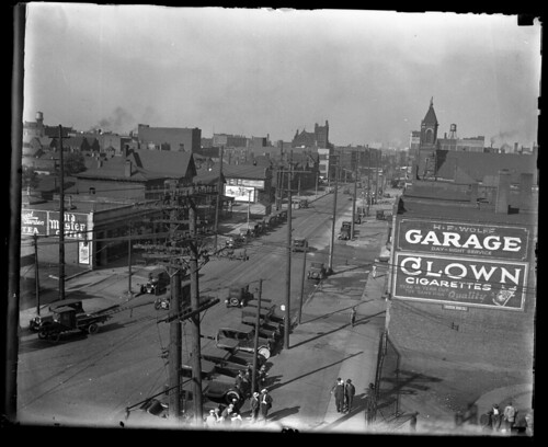
This photo shows the view west on Carnegie Avenue from East 14th Street. The sign of H.F. Wolff Garage can be seen on the right. We can also see the spires of St. Anthony of Padua. Other than that, just about all of the buildings shown here - both houses and commercial establishments - are now gone.

There are so many questions. What is the building in the distance, in the center, that looks like a church? And what enterprise was served by the distant water tower?

These photographs help to serve as a historical record of this bit of lost Cleveland. In the next group of photographs, I'll explore more of this now-lost section of Carnegie Avenue.