Showing posts with label books. Show all posts

Tuesday, November 1, 2011

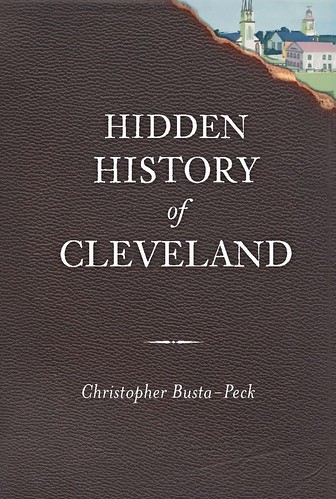
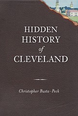
Release Party for Hidden History of Cleveland

Your Chance to Buy Dozens of Copies of My Book and Get Them All Signed

On Friday, November 11, 2011, at 7pm, Loganberry Books will host a release party for my first book, Hidden History of Cleveland. The author will talk and sign copies of the book. Refreshments will be served. There will be a door prize, including Cleveland Area History swag and local history books.

To quote the jacket copy,
In Hidden History of Cleveland, Busta-Peck unearths aspects of Cleveland’s past that dangle too near extinction from city memory. Too often, we think of history as something that happens elsewhere. But it’s not. Travel down East 100th Street to the home where Jesse Owens lived when he shocked the world at the 1936 Olympics. Ascend the stairs to Langston Hughes’s attic apartment on East 86th, where the influential writer lived alone during his formative sophomore and junior years of high school. From the massive Brown Hoist Building and the Hulett ore unloaders to some of the oldest surviving structures in Cleveland, Busta-Peck has Clevelanders talking about history again.

Loganberry Books is located at 13015 Larchmere Blvd, Cleveland, OH 44120. It is in the heart of the historic Larchmere neighborhood. It is the largest independent bookstore in Cleveland. Loganberry has the largest selection of local history books in Cleveland, including many unique and hard to find items.

If you're unable to attend, there will also be a signing at Mac's Backs, on Coventry Road in Cleveland Heights, on Tuesday, November 15, at 7pm.

Other signings and events will be announced as they are scheduled.

Friday, October 14, 2011

Hidden History of Cleveland

The Answer to All Your Holiday Gift Giving Problems

Hidden History of Cleveland

Wonder about the lack of posts from me here during the summer and early fall? My time was eaten up by the editing of Hidden History of Cleveland. My publisher, History Press, describes it thus:

Join local history preservationist Christopher Busta-Peck and unearth aspects of Cleveland’s past that dangle too near extinction from city memory. Too often, we think of history as something that happens elsewhere. But it’s not. Travel down East 100th Street to the home where Jesse Owens lived when he shocked the world at the 1936 Olympics. Ascend the stairs to Langston Hughes’s attic apartment on East 86th, where the influential writer lived alone during his formative sophomore and junior years of high school. From the massive Brown Hoist Building and the Hulett ore unloaders to some of the oldest surviving structures in Cleveland, Busta-Peck (the wildly popular Cleveland Area History blog) has Clevelanders talking about history again. Here’s why.

In short, it's a selection of the very best material from Cleveland Area History, with a third to half of the extra words cut out. It's scheduled for publication in early November - just in time for the holidays. Just think: you could give a copy to each and every one of the impossible-to-shop-for but nonetheless obligatory gift recipients on your list.

Preorder it from Amazon, Barnes and Noble [at a marginally significantly better price], or your favorite independent bookstore.

Wednesday, October 5, 2011

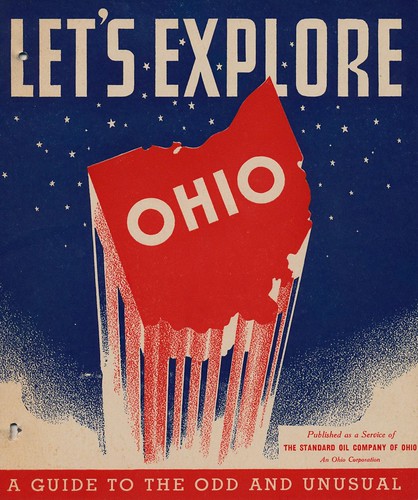
Let's Explore Ohio!

Let's Explore Ohio Coloring Book
Image courtesy of Jordan Smith / What Makes Pie Shops Tick?

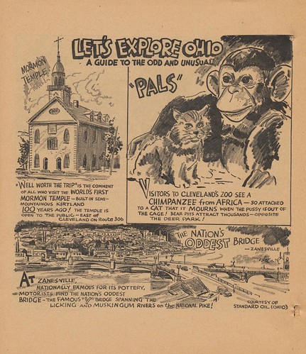
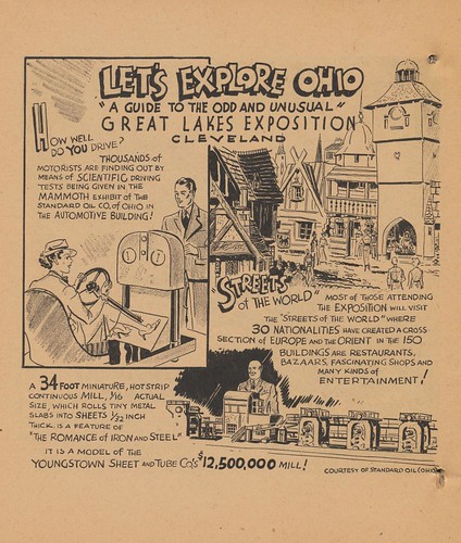
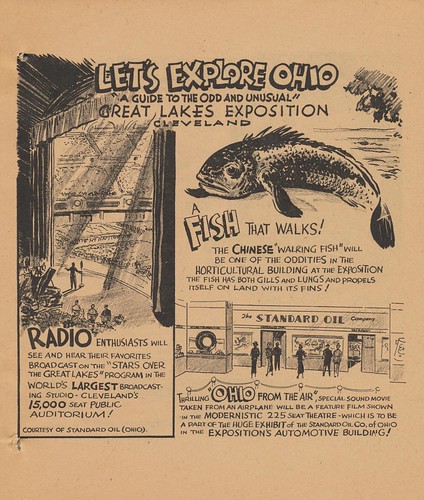
John Vacha's latest book, Meet Me on Lake Erie, Dearie! had me thinking about the 1936-37 Great Lakes Exposition, a grand fair held in Cleveland.

In a local collection, I came across this coloring book, created by Sohio, presumably as a giveaway for the exposition. I was going to scan it myself, but then I thought "Hey, I really should see if someone else has done that first."

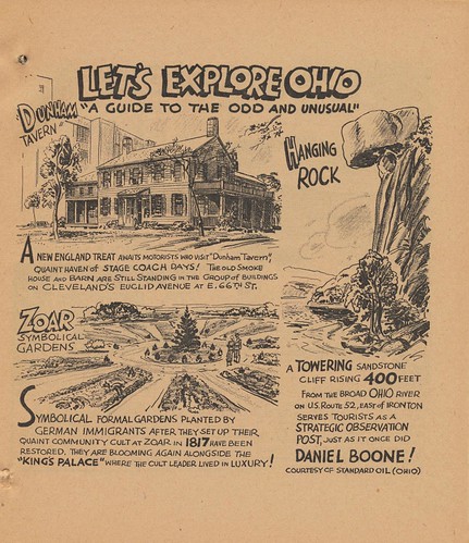
To my surprise, Jordan Smith / What Makes Pie Shops Tick? had already scanned the book in its entirety. This post includes select pages that deal with the Cleveland area. If you like it, you might want to check out the whole book. Heck, you might even want to print out some of the pages for coloring, for your kids or yourself.

Note: The language and tone are, um, what you might expect for the period, so you might want to read them before giving them to your children.

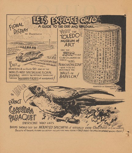
Floral Display
Image courtesy of Jordan Smith / What Makes Pie Shops Tick?

I wonder how many of the nurseries mentioned here are still present.

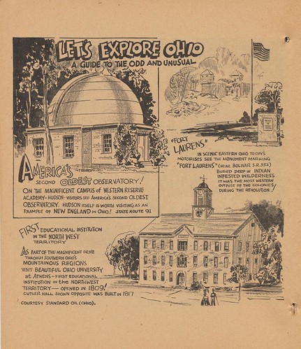
Fort Laurens
Image courtesy of Jordan Smith / What Makes Pie Shops Tick?

The observatory at Western Reserve Academy, in Hudson - the second oldest in the country - is a historic site that seems to mostly be forgotten. The reminder of its existence is most welcome.

Pals
Image courtesy of Jordan Smith / What Makes Pie Shops Tick?

The Kirtland Temple, on the other hand, remains prominent. It's unclear what became of the "Pals" at the Cleveland Zoo.

Hanging Rock
Image courtesy of Jordan Smith / What Makes Pie Shops Tick?

The Dunham Tavern receives mention as well.

More Great Lakes Exposition
Image courtesy of Jordan Smith / What Makes Pie Shops Tick?

Finally, we're greeted by two pages, sharing the wonders of the Exposition. How many remain wonderous to you, today?

Great Lakes Exposition
Image courtesy of Jordan Smith / What Makes Pie Shops Tick?

Wednesday, March 23, 2011

Visions of a City in 1872

Cleveland as seen in Picturesque America
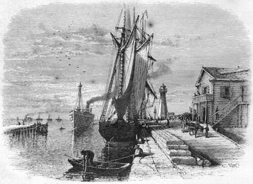
Mouth of Cuyahoga River, Cleveland

Picturesque America was a massive two volume set, first published in 1872. It is best known for the high quality illustrations of various natural features across the United States. In a way, it was the first popular coffee table book.

In addition to the aforementioned natural wonders, the title also provides glimpses of life in cities across the country. Cleveland was included among these. A Cleveland Area History reader was kind enough to let me borrow a copy, so that I might make a high-resolution scan of the images - be sure to click through for more detail, if so desired. All are from the edition published by D. Appleton And Co., New York, 1872.


The chapter opens with, Mouth of Cuyahoga River, Cleveland (page 521) - shown above. Compare it to Otto Bacher's prints and drawings, which cover the same area, at about the same time. In the drawings, there is a certain quality of composition that is shared with this image. In Bacher's prints, it becomes darker, perhaps partially due to the nature of the etching process.
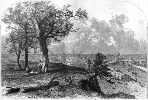
Cleveland, from Scranton's Hill

This is followed (page 523) with Cleveland, from Scranton's Hill. The location today is close to West 17th Street, just north of Lorain Avenue - immediately before it crosses over the Cuyahoga River and becomes Carnegie. From this promentory, we can see a good part of the residential area of the city, as well as the industry that would transform it in the following years. If we look in the distance, in this historic view, we can see the steeples of several churches.
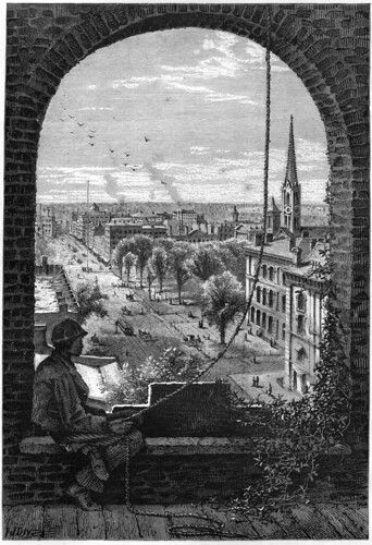
Superior Street, Cleveland, from Presbyterian Church

One of these provides a view of downtown Cleveland, looking west, in Superior Street, Cleveland, from Presbyterian Church (page 525). Second Presbyterian Church was located on the south side of Superior, just west of  where the Arcade is located today. In the midground, there is a group of trees - Public Square. Adjacent to that is the one structure that remains from this historic view - the Old Stone Church. Immediately between the the viewer and the church is the old post office and custom house.

A flagpole is visible near the center of Public Square. Behind this, on the right side of the street, is a building with a dome. This is the Weddell House, one of the city's best known early hotels.
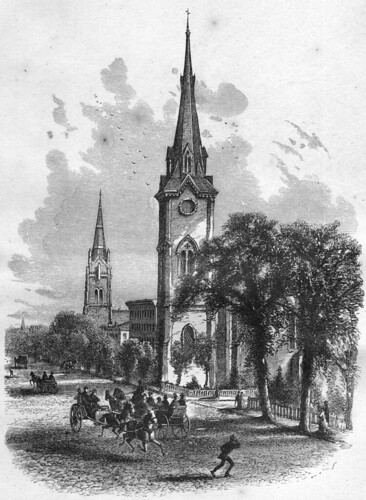
Euclid Avenue, Cleveland

On the following page, we are provided with this view of Euclid Avenue, presumably looking east. I must confess that I cannot, with the resources I have in hand at the moment, identify the specific churches. Update: thanks to Kevin's comment below, I can now identify the scene. The view is indeed looking east, from about East 13th Street. The church in the foreground is the Euclid Avenue Presbyterian Church. It was located at what is now East 14th Street. In the distance, we can see the tower of the Euclid Avenue Baptist Church, at the corner of what is now East 18th Street.
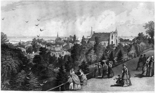
City of Cleveland, From Reservoir Walk

The Ohio City neighborhood is illustrated through this engraving, City of Cleveland, From Reservoir Walk, bound between pages 528 and 529. The reservoir was located on the block bounded by the streets now known as Franklin Boulevard on the north, West 32nd Street on the east, Woodbine Avenue on the south, and West 38th Street on the east - the block that now includes Fairview Park.

The reservoir provided an excellent view of the city. About a third of the way from the right, the Methodist Church is visible. Just behind that is the steeple of the Baptist Church. Off center, in the distance, the First Congregational Church can be seen. In the distance, we can see Lake Erie, with several boats sailing on it.
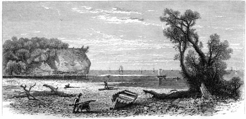
Mouth of Rocky River

The two remaining views of the Cleveland area are both of the Rocky River. One, here, provides a view from close to the river itself. The other shows the lake from a bluff overlooking it.

From here, the authors continue west, with two views of the Black River in Elyria. The commercial importance of Sandusky is illustrated through lumber boats there, not unlike the scene at the mouth of the Cuyahoga here in Cleveland. In addition, we are provided a view of the city iteself.
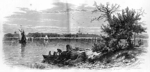
Put-in-Bay

The journey west continues to Kelly's Island, and then to Put-In-Bay, shown here. At Put-In-Bay, we are given a look into Perry's Cave and two features on Gibraltar Island, in the harbor at Put-In-Bay, - Perry's Lookout and the Sphinx Head.
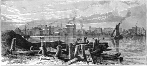
Toledo, Ohio

The journey along the south shore of Lake Erie concludes with this view of Toledo. In many ways, it seems to resemble Cleveland.


These views provide an idealized view of Cleveland and the adjacent areas in the 1870s. Looking at them and then at Cleveland as seen by Otto Bacher would be an interesting exercise - Bacher's drawings and prints provide a somewhat different perspective.

I'm always looking for unpublished or underutilized historic imagery of northeast Ohio. If you have books or photographs that you are willing to share, please contact me, that I might scan them and share them with a wider audience.

Tuesday, February 15, 2011

Our Citified County

Looking at Land Use in Cuyahoga County in 1954

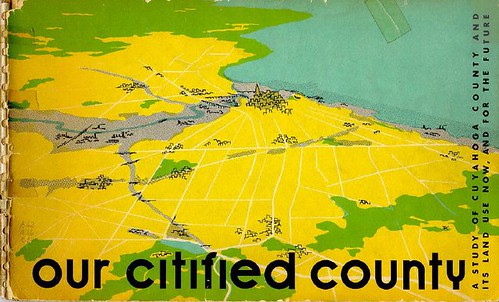
Cover

The Cuyahoga County Planning Commission recently digitized an interesting document, Our Citified County: A Study of Cuyahoga County and Its Land Use Now, and for the Future. The title, published in 1954 by the Regional Planning Commission, examines land use in Cuyahoga County.

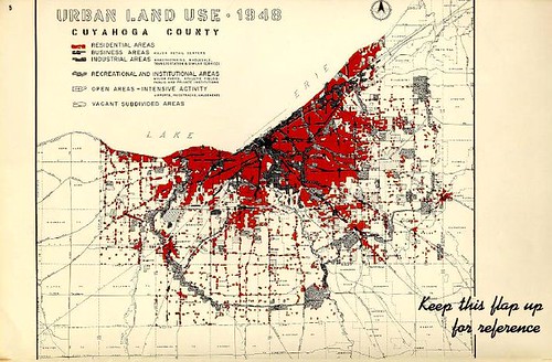
Land Use 1948

Maps illustrate the use of land within the county, as of 1948. The red shows residential areas, while the darker areas are indicative of business and industry. We can also see the dedicated parkland, especially in the outlying areas - most notably the areas now known as our MetroParks.

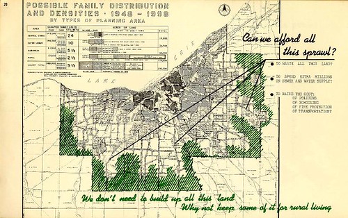
Can we afford this sprawl

The authors suggest that the vacant land at the extremities of the county might most cost-effectively remain as rural land.

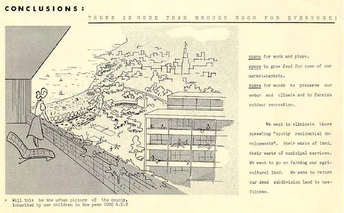
Conclusion

The document concludes by painting a picture of the Cuyahoga County of the future - both literally and figuratively. There's the suggestion that proper land use wout provide space for us to grow our food locally, provide space for work and play, and for us to preserve water quality.


Overall, it's an interesting view of how we might have developed in the past 50 years. The questions raised are many of the same ones that we're facing now, though the vacant land is in different areas now.

Wednesday, June 30, 2010

Picturesque South Brooklyn Village

Charles H. Miller residence

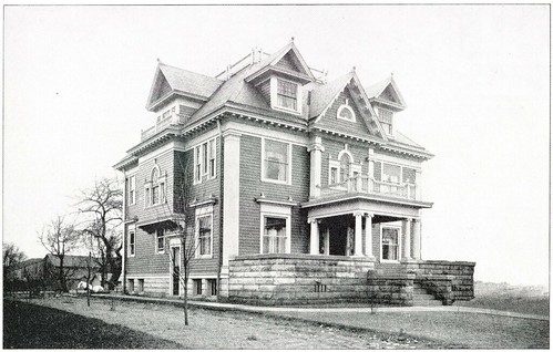
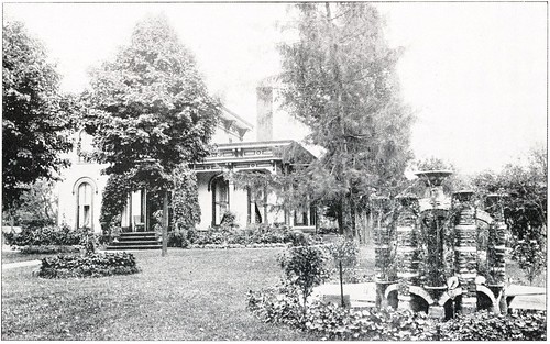
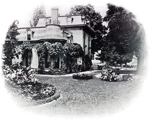
Recently, I came across a wonderful little book, published in 1903 by the South Brooklyn Improvement Association, promoting real estate in the the village. Picturesque South Brooklyn Village has numerous high quality illustrations, so I scanned the vast majority of them, knowing that they'd be useful at some future date. The only ones that I've omitted are small, nondescript landscapes and portraits.

At first, my intent was to drive around and photograph all the extant structures illustrated in the book. A lack of available time has made this impossible. Through the use of this map, I've been able to identify the current names of the streets. For the structures that are still standing, I've used the Cleveland GIS to identify the addresses.

John L. Johnson residence

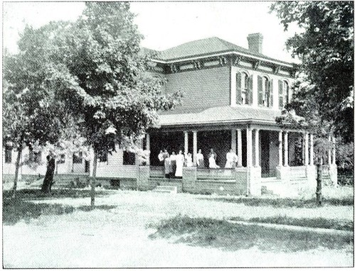
The biggest surprise has been how many of the buildings pictured in 1903 are no longer standing. More than 75% of the strutcures appear to have been demolished. Many were residences on Pearl Road and Broadview Road, which were demolished to make way for commercial structures. Many of the commercial structures appear to have been removed to make way for new buildings as well. The Italianate style residence of John L. Johnson, on Pearl, was one.

Charles Gates residence

This Second Empire style residence of Charles Gates, also on Pearl, is another example.

Howard C. Gates residence

The Howard C. Gates residence, at 4248 West 35th Street, may be more well known than some of the other houses, due to its location next to the Jeremiah Gates residence, thought to be the oldest house in the city of Cleveland.

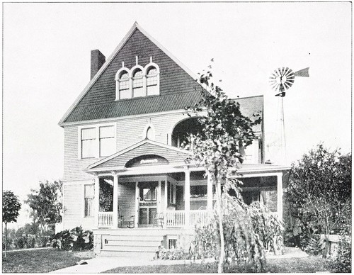
Dr. H.H. Webster residence

This house, the residence of Dr. H.H. Webster, is another one of my favorites. It, too, alas, has been lost. Note the presence of a windmill in the back yard, presumably to pump water.

William C. Buchwald residence

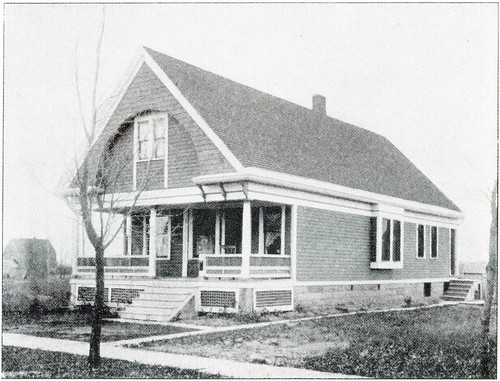
The William C. Buchwald residence, at 4112 Bucyrus Avenue, is one of my favorites of the lot that is still standing.

Charles A. Dainz residence

Some of the houses, like the Charles A. Dainz residence, at 3816 Bucyrus Avenue, have been so extensively remodeled that they are hard to identify. Perhaps these photos will be useful for future inhabitants looking to return the buildings to their original glory.

I've identified these photos to the best of my ability. Take a look at the set. Check out the book from your local Cleveland Public Library branch. If you know of one that I've missed, I'd love to hear about it. I'd also love to see current photos of any of the buildings, if you have them.

Thursday, January 14, 2010

The History of the Veterans Memorial Bridge


Image courtesy of the Cleveland Memory Project Poscard Collection

I confess I was a bit skeptical when Bill Barrow offered me a review copy of William E. Beyer's The History of the Veterans Memorial Bridge: 90th Anniversary Edition. "How can there possibly be 600 pages worth of material on the Detroit-Superior Bridge that anyone would be interested in reading," I asked myself. Further, I thought, "how the heck will I slog through it?" I quickly learned that my fears were unfounded. The 600+ page, 3.5 pound tome is mostly pictures - "profusely illustrated" is the polite term, I think.

William E. Beyer became interested in the history of the bridge while working as project manager for Howard, Needles, Tamen & Bergendorf on its 1995-1996 rehabilitation. He assembled a massive weath of information which was originally distributed in 2001, in a very limited edition, run off on the office laser printer. This reprint is on nice, heavy, glossy stock, with a sewn hardcover binding.

Rather than a book, imagine The History of the Veterans Memorial Bridge as an impressive, well documented archival collection. All of the photographs that you might find in an archive, all the historical documents, everything. Further, it's explained by someone who clearly knows the subject.

Byers begins by documenting the need for a high level bridge, describing the frequent traffic jams and malfuntions suffered by the old Superior viaduct. He goes on to describe the purchase of the real estate, the bidding of the contracts, and more. In addition to photographs, the illustrations include many editorial cartoons depicting the political battles surrounding the construction of the bridge.

When we get to the actual construction of the bridge, it becomes quite obvious that Byer is an engineer. The discussion becomes quite technical in nature, though still readable to the layperson, for the most part. The photographs of the actual construction are impressive. They show, in exhaustive detail, the work on the bridge. Each and every step in the building process is docuemented in detail.

Byer continues, providing photographs of the use of the bridge by automobiles, streetcars, and pedestrians. Streetcars ran on a second level, underneath the bridge. The construction and design of this and the approaches are documented fully. Readers will also be interested to see in the photographs various buildings in the flats and at the ends of the bridge that are no longer present.

In the 1950s, streetcars lines under the bridge were shut down. A feasability study was conducted to determine whether cars could run on the lower level. It was determined that they could not, and the access wells on each end of the bridge were filled in.

The documentation includes the two major rehabilitations of the bridge, in 1967-1970 and 1995-1997. That the damage was allowed to get as far as it did is concerning at times. It is impressive to see how it all went back together.

Byer also provides brief biographies of some of the engineers on the building of the bridge and some of the involved a companies. A massive fold-out technical drawing of the bridge is also included. Appendices contain bridge contracts, bid quantities and prices for the original construction, both rehabilitations, and the 2004 promenade. Additional appendices contain correspondence relating to the bridge, sample design calculations, and some basic computations of the geometry and stresses on the bridge. Beyer finishes the book with an exhaustive bibliography.

This is not simply a book for the bridge nut. It's one of the better photographic collections that I've come across dealing with the history of the area. It's priced right, too, at $40, shipped. While that isn't exactly cheap, for a 600 page book of photographs, it's a good deal. You can fill out the order form and mail it in or save $10 by picking it up in person at the Cleveland State University Michael Schwartz Library.

Tuesday, January 12, 2010

Book reviews

In the near future, we will start reviewing books relating to local history on this blog. We know that there are a lot of interesting titles out there that haven't received the exposure they deserve. If you have a book that you would like to send us a copy of, contact us at clevelandareahistory@gmail.com for our mailing address. Receipt of a book does not guarantee a review, nor can we promise that you will like what we have to say.

That said, we'd like to start sharing some local books. Please, send them our way!

Thursday, December 10, 2009

Book reivew: Ohio Archaeology

Ohio Archaeology: An Illustrated Chronicle of Ohio's Ancient American Indian Cultures by Bradley T. Lepper (2005) is the best book yet written on the subject. Most of what has been written on Native Americans in Ohio is either geared toward an elementary audience or is so academic as to be unreadable by those without a background in the field. This book finds a middle ground.

Written at about a tenth or eleventh grade level, Ohio Archaeology is written like a textbook, with the exception that it is far more willing to deal with difficult questions than most textbooks. The individual chapters are written by scholars and experts.

The work is profusely illustrated with a variety of media. Maps illustrate the geology of Ohio in each time period. Illustrations from 19th century publications show what the various features looked like before they had eroded so much or were destroyed entirely. Aerial photographs with drawings superimposed help to show what remains of these earthworks, and how to see them against the landscape. The artifacts themselves are also well documented, as are the processes through which they were located.

Ohio Archaeology addresses the subject matter in chronological order. It incorporates some sites in surrounding states, especially for the earlier history, in order to explain the conclusions reached. It does everything that I might want in such a book.


There's one other book that might rival this one for shelf space, if I had to choose: Ancient Monuments of the Mississippi Valley by Ephraim Squier and Edwin Davis. Ancient Monuments, or, more commonly, Squier and Davis, was, in 1848, the first publication of the Smithsonian Institution. It documented many of the earthworks that have since been lost. When you see a historic illustration of a mound in Ohio, chances are good that it is from this book.

The title is a bit misleading. By "Mississippi Valley", the authors meant, by extension, the Ohio River valley, where many of the Ohio sites are located. This doesn't stop them from also addressing several sites in nothern Ohio, documented by Charles Whittlesey.

The Smithsonian Institution published an excellent reprint of Squier and Davis in 1998, on the 150th anniversary of the original. It is better than most reprints, and a title that I highly recommend.

If not for Squier and Davis, we would not have documentation of many of the major earthworks in the Ohio valley. Few met the same level of quality and accuracy. If not for this title, we wouldn't even have the record of what we have lost.


If I had to choose between Ohio Archaeology and Ancient Monuments, it'd be difficult. As a lover of history, I'd choose Ancient Monuments, with its lovely plates illustrating dozens of sites. As a librarian, I'm inclined toward Ohio Archaeology, so that I might actually understand what I am seeing.

Sunday, December 6, 2009

Ancient Fort, Newburg

The other day, I was browsing Charles Whittlesey's Early History of Cleveland, Ohio, looking for something interesting to write about. I came across the following map, illustrating a "Ancient Fort" in Newburg Township.


I've always been interested in the prehistory of this area. So many of the impressive earthworks are located in southern Ohio that those that had existed in the northern part of the state are usually forgotten. It further helps that Whittlesey provides such a great description of the location:

This consists of a double line of breast works with ditches across the narrow part of a peninsula between two gullies situated about three miles south easterly from the city on the right of the road to Newburg on land heretofore owned by the late Dr. H. A. Ackley. The position thus protected against an assault is a very strong one where the attacking party should not have projectiles of long range.

On three sides of this promontory the land is abrupt and slippery It is very difficult of ascent even without artificial obstructions Across the ravine on all sides the land is upon a level with the enclosed space The depth of the gully is from fifty to seventy feet About eighty rods to the east upon the level plain is a mound ten feet high and sixty feet in diameter At the west end of the inner wall is a place for a gateway or passage to the interior.

The height of the embankment across the neck is two feet and the enclosed area contains about five acres. Perpetual springs of water issue from the sides of the ravine at the surface of the blue clay as they do at Cleveland.


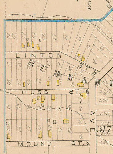
I began by checking the 1858 Hopkins map which showed that the land owned by Dr. Horace A. Ackely was located south of Broadway, between East 55th and East 65th Streets. This is further corroborated by the presence of streets named "Ackley" and "Mound".

The problem is that the landscape shown in Whittlesey does not correspond at all with what is present today. The stream shown in the picture, Morgan Run, has been culverted, and the gullies, bulldozed flat. I thought perhaps in another historic atlas might show the location of the stream, which would give me a starting point. The 1881 City Atlas of Cleveland Ohio gave me what I needed. The stream isn't a perfect match, but it's the best approximation of the general shape that I've been able to find.


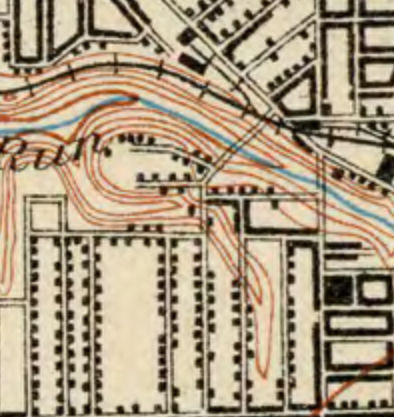
It still remains to correspond the historic geology with modern roads. A solution to this problem was found in this turn of the century USGS topographical map, found on Rails and Trails.

morgan run

The following is my best approximation of the location of the fort and the associated mound to the east:

View Ancient Fort, Newburg in a larger map

I visited the area, looking for anything that my might look even faintly mound-like, but alas, there seems to remain no physical evidence of either the defensive mounds or the circular one to the east.