Showing posts with label 1930s. Show all posts

Tuesday, January 31, 2012

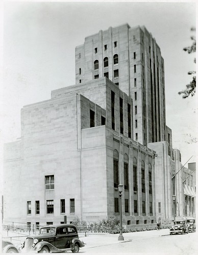
Wait, this Art Deco skyscraper was in Cleveland?!

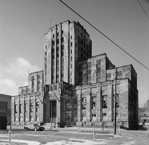
Cuyahoga County Criminal Courts Building
Cuyahoga County Criminal Court Building, July 1936. Created by the staff of the Ohio Federal Writers' Project. Image used courtesy of the Ohio Historical Society.

When I first came across photographs of this building, in the documention collected by the Historica American Buildings Survey, I was sure that the caption was wrong. A building like this, in Cleveland? Surely I would have heard something about it. Surely I would have been able to find some mention of it, somewhere.

A brief search was fruitless. Surely, a building of this stature and of this significance within the criminal justice system would have merited some mention or record, somewhere. (Note: a recent search reveals a photograph in the collections of Cleveland Public Library.)

As a result, the building didn't stick in my mind - I assumed it had to be somewhere other than Cleveland.

01
Detail of a photograph, used courtesy of the Historic American Buildings Survey.

A recent reinspection of the photographs forced me to accept that this building was, in fact, in Cleveland.

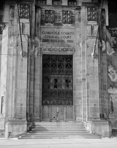
06
Detail of a photograph, used courtesy of the Historic American Buildings Survey.

Note the text over the front door; "Cuyahoga County Criminial Courts Building".

The structure, designed by Cleveland architects Warner and Mitchell, was completed in 1931. It was located at 1560 East 21st Street.

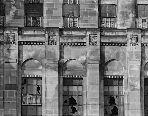
07
Detail of a photograph, used courtesy of the Historic American Buildings Survey.

These photographs were likely taken close to the date of demolition, in the 1990s. Even then, the building retained much ornament and architectural detail.

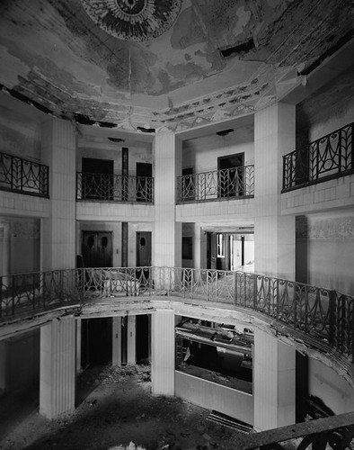
10
Detail of a photograph, used courtesy of the Historic American Buildings Survey.

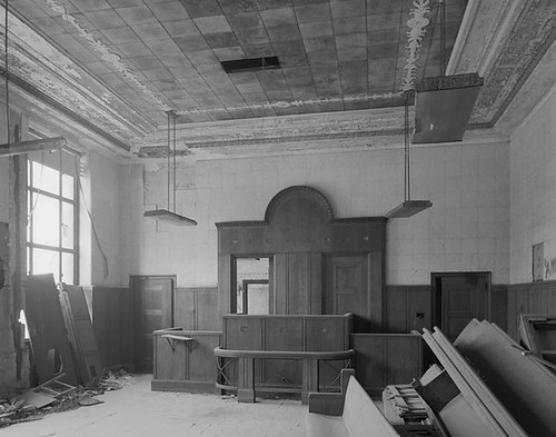
This level of detail continued inside. While the space shows considerable decay, the original grandeur is clearly visible.

12
Detail of a photograph, used courtesy of the Historic American Buildings Survey.

This level of detail continued into the courtrooms, which somehow remained mostly unchanged for decades.

The building was replaced, leading to the decay of this structure. The Historic American Buildings Survey has more photographs - it's worth taking a look.

Friday, December 2, 2011

Mystery Painting: Win a Signed Copy of Hidden History of Cleveland!

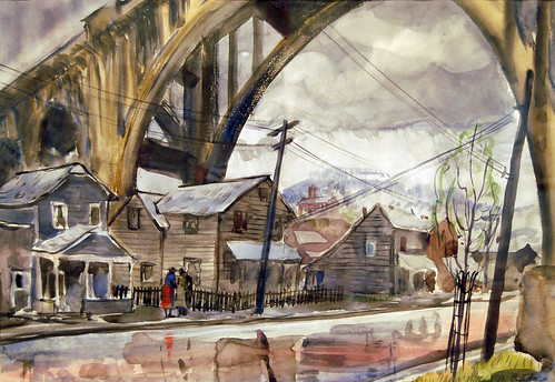
Under the Bridge by Willard Combes

Since I first saw this watercolor painting, Under the Bridge by Willard Combes in the book Masterworks from the Cleveland Artists Foundation, I've liked it. The image, painted in the 1930s, is said to be of a Cleveland neighborhood. But where, exactly, is that neighborhood?

The combination of a high-level bridge and residential street ought to provide enough information for one to identify the site where Combes found this composition - there aren't that many high-level bridges in this town - yet it remains unknown. The various maps available through the Cleveland Public Library might contain the clues you need.

Be the first to identify the site, either by posting a comment here or to the Cleveland Area History Facebook page, and you'll win a signed copy of Hidden History of Cleveland. If you can, a link to the map showing the location would be most helpful for the rest of us

Monday, November 14, 2011

Cleveland's Oldest House - Identified

Cleveland's Oldest House
Photo from the Cleveland Press Collection, used courtesy of the Cleveland Memory Project.

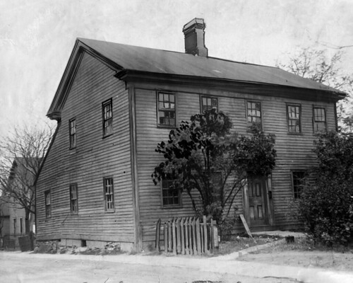
Last week, I shared this photograph, of a structure said to be Cleveland's Oldest House. The caption noted that it was located at West 93rd and Lorain - but I couldn't find anything in the historic maps of that area that matched up with the footprint of the house.

I offered a signed copy of Hidden History of Cleveland, for anyone who could identify the location of the structure or whose house it actually was.

Craig Bobby took up the task. He said,
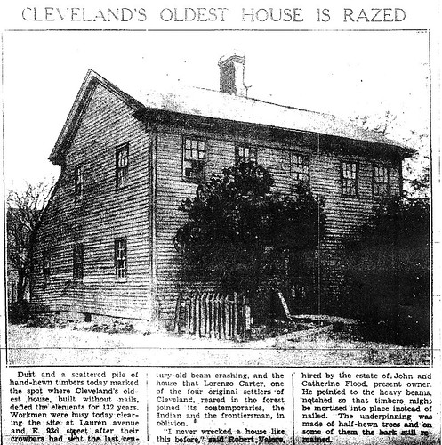
I decided to "look up" whatever I could regarding the alleged Lorenzo Carter house, demolished in 1932, by looking in the Press, circa September 15, 1932. I did succeed in finding what was needed, published, by the way, in that very same date's edition.

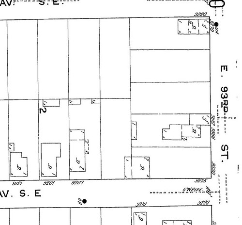
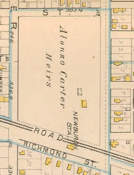
Detail, 1913 Sanborn
Detail, 1913 Sanborn map. Used courtesy of Cleveland Public Library. Loren is the street running left-right near the bottom of the image. Our house is at the corner of Loren and East 93rd, the street running top to bottom.

He continued,
This house was neither at West 93rd nor Lorain; it was at East 93rd and Loren. This would be a small number of blocks north of Harvard, just outside of the original Newburgh Village. The article misidentifies the side-street as 'Lauren'. Its exact address was 3890 East 93rd -- it was on the northwest corner. You could see, from looking at the 1913 Sanborn map, that the house was set back considerably from the street. It has such a setback on both the 1881 and 1858 maps. The house behind it in the 1932 photo was the first house on the north side of Loren.

Detail, Plate 26, 1881 City Atlas of Cleveland, Ohio
Detail, Plate 26, 1881 City Atlas of Cleveland, Ohio - used courtesy of Cleveland Public Library

Craig Bobby said,
I checked the 1881 City Of Cleveland Atlas and the 1858 Cuyahoga County Map. This house was on the property of Alonzo Carter, not Lorenzo Carter. I also looked at various historic Censuses and found an Alonzo Carter in Newburgh as far back as 1850. Both the 1840 and 1830 censuses have an Alonzo Carter living in Brooklyn, not Newburgh. I personally believe that they are all the same person. Those older censuses only listed age-groups, but, considering this, they seem to be about the same person, with knowing that the 1850 census has his age as being 60. Assuming from all of this that Alonzo Carter moved from Brooklyn to Newburgh sometime between 1840 and 1850, I think that it could be legitimately suggested that the house was built by him whenever that was that he arrived there in Newburgh. If not, then he acquired an already-built house. Regardless of the story of the alleged "primitive" construction features made visible during demolition, I still can not accept that this house was built in 1800 -- at least not the house as we see it in the photo. Could it have been a log cabin extensively remodeled in later years? We will never know.

The Dictionary Of Cleveland Biography article on Lorenzo Carter says that he had a son named Alonzo. I am willing to believe that this is that person. The Dictionary says Lorenzo was at least born in Connecticut, while the 1850 census says that Alonzo was born in Vermont. Lorenzo could have moved from Connecticut to Vermont -- they are quite near each other. The 1850 census also says that Alonzo Carter had a son named 'Lorain'. I believe that this is a misspelling; I bet his name was Loren (likely a 'diminutive' of Lorenzo). This should 'explain' why the side-street was named Loren. And, according to the Cleveland Necrology File, Alonzo Carter died in 1872 (quite possibly in this very house) at the ripe old age of 82.

Cleveland's Oldest House is Razed

He was kind enough to provide a copy of the article as well.

For his efforts, Craig Bobby will receive a signed copy of Hidden History of Cleveland.


While we now have the correct location for the photo, we are left with more answers than questions. Perhaps someone else, at some future date, will take interest in this and see what else can be learned about the history of this historic home.

Monday, November 7, 2011

Cleveland's Oldest House

Cleveland's Oldest House
Photo from the Cleveland Press Collection, used courtesy of the Cleveland Memory Project.

When I come across a photo with the title "Cleveland's Oldest House", I can't resist. Such was the case with this photograph, found on the Cleveland Memory Project. (For the record, the amount of new stuff that continues to show up there is just ridiculous. How am I supposed to keep track of so much interesting new material?)

The description of this photo, from the Cleveland Press Collection, reads "Old Lorenzo Carter Homestead, Cleveland's Oldest House, Lorain Ave. and 93rd St., Cleveland apartments and residences, Built 1800, Razed 1932." It's dated September 15, 1932.

There are several problems with this caption. I've yet to see any evidence that Lorenzo Carter lived in this vicinity - he is known to have lived much much closer to downtown Cleveland. Further, I wasn't able to locate a pair of structures meeting the profile of the two shown here on the Sanborn fire insurance maps for the area in question.

Still, it seems strange that this would all be wrong - there must be some factual basis behind some of it, right?

The house definitely fits the period - it dates between 1800 and 1830. It would help if the photograph hadn't been retouched so heavily, but there's not much that can be done about that now.

Who was this house really built for? Where was it located? What else can we learn about it?

Answer any one of these or provide substantial information that helps in the process and you could win a copy of my forthcoming book, Hidden History of Cleveland. (I'll do a random drawing from all the answers that help lead to the identification of the structure.)

To help in this quest, Bill Barrow, Special Collections Librarian at Cleveland State University, has been kind enough to let me use a full resolution copy of the image (2750x2200!) - click on the image to get through to the bigger file. Perhaps there is some clue hidden away in it that will help answer the question.

How might one start the search? Perhaps one might find the corresponding article in the Cleveland Press. Or perhaps there's another spot that seems right. Or perhaps a historic map reveals something that I've missed. Wherever you find the clues, post them here or on our Facebook page and join in the conversation!

Thursday, November 3, 2011

Inside the Oakwood Club

Clubhouse

A little while ago, I introduced the history of the Oakwood Club, a country club on Warrensville Center Road in Cleveland Heights and South Euclid. Here's the second part of the story - a look at the interior of the club, with photographs provided courtesy of Terry Coyne.

The Excelsior Club merged with Oakwood in 1930. The increase membership necessitated building a new clubhouse. The building, completed in 1931, was designed by George B. Mayer of Charles R. Greco & Associates. The firm was also responsible for the design of the Temple at University Circle (Temple Tifereth-Israel) and the Temple on the Heights, on Mayfield Road at Lee, in Cleveland Heights. Louis Rorimer, of Rorimer-Brooks Studios, was responsible for the interior decoration.

James C. Monnett, Jr. described it as follows (Plain Dealer, December 4, 1930, page 25)

Contract for construction of additions and improvements to the Oakwood Club has been awarded to the Sam W. Emerson Co., the club's president, J.M. Berne, announced last night. Work is to go forward immediately and will mean an expenditure in excess of $100,000.

Enlargement of the clubhouse is in connection with the plan to consolidate it with the Excelsior Club which recently sold its club property at 11111 Euclid Avenue to Western Reserve University, which will take possession as soon as Oakwood enlargements are completed. Arthur J. Halle is president of Excelsior.

Plans call for addition of two wings and remodelling of the present building. One of the new wings will contain a lockre room 60 x 120 feet with an outdoor dancing pavillion on the roof. The other wing will contain a large lounge, handball courts, bowling alleys, private rooms and other facilities. If weather permits it is expected to have a new locker room reading for use in early spring and the entire construction job finished early in June. Plans are by the Charles R. Greco organization, Edward G. Reed associated. The building committee is S.M. Gross, chairman; Alex Printz and Gamuel Regar.

Further, (Plain Dealer, June 28, 1931, page 41)
The new club, which in reality is the enlarged club on the former site near Warrensville Center and Mayfield Roads, is a beautiful structure with interiors in the French provincial style.

The main lounge is several steps below the entrance hallway. Back of it is a tea room which will open onto a terrace. The large dining room occupies the space of the original Oakwood club dining room.

There are seveal private rooms which may be opened into the main room for large gatherings. From the dining room to the roof garden is a "peacock alley." The roof garen is atop the section which houses the men's locker room. The women's lockers and dressing room are on the second floor.

Cornelia Curtiss, in an article describing the programs several clubs had planned for the 4th of July (Plain Dealer, July 4, 1931, page 10), notes:
One of the most interesting will be the dinner dance which formally opens the new and enlarged Oakwood Country Club at Mayfield and S.O.M. Center Roads. Not only will the dinner dance which is planned for the evening be the first social event to be held here, but it will mark the 25th anniversary of the original Oakwood club's founding.

The interior of the beautiful club is furnished in French provincial style. The "peacock alley" which leads from the main dining-room to the roof-garden, has been decorated with silver leaves and other silver novelties to mark the silver anniversary. The roof garden which tops the men's locker quarters is covered with a gay awning and is the only roof of its kinds among country clubs of this community.

A trio of photographs published in the Plain Dealer a couple weeks after the opening (July 19, 1931, page 6) might have illustrated the interior well, prior to being microfilmed. The same article notes that the total cost of the project, with furnishings, was $250,000.


Awning, Clubhouse

On arriving by automobile at the main entrance to the clubhouse, a valet would likely park your vehicle.

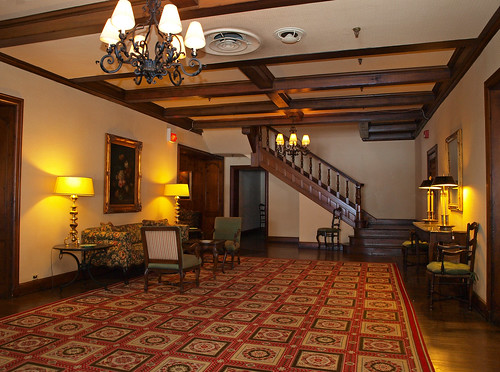
Entrance Foyer
Photograph used courtesy of Terry Coyne.

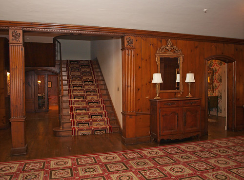
You'd be greeted by this entrance foyer, trimmed with dark wood, probably walnut. The furntiture present here could well have been part of the items selected and installed by Rorimer - I'd have to see it in person to make that determination. On the other hand, in settings outside private residences, furniture tends to have a shorter lifespan.

Stairs to Ladies L...
Photograph used courtesy of Terry Coyne.

To your left, there's a staircase leading up to the second floor. Note the detail of the carving in the trim - something Rorimer-Brooks was known for.

Living Room
Photograph used courtesy of Terry Coyne.

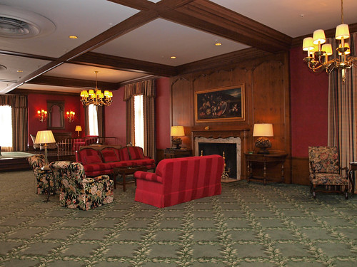
To your right, from the entrance hall, is the living room, a large space that stretches all the way to the south wall of the structure. The listing photographs include another view, but this doesn't provide much illumination into the architecture of the structure.

Fireside Alley
Photograph used courtesy of Terry Coyne.

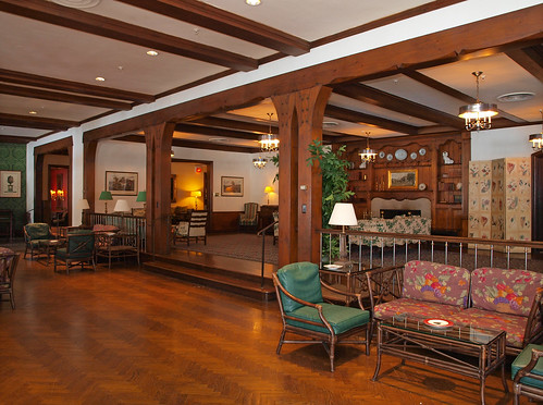
The "fireside alley" is connected to the living room - through the arch on the far left, we can see a little bit of the red of the walls in that room. Massive timbers appear to support the ceiling, providing a visual separation between lounge areas closer to the fireplaces and those that, as built, would have been near the outside wall.

Fireside Alley
Photograph used courtesy of Terry Coyne.

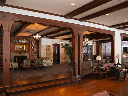
Another view, just to the right of the one above, provides a second look at the "fireside alley". On the far right, the wood paneling on the walls of the dining room is visible.

The listing photographs also provide views of some areas that were added later, and are of perhaps less architectural interest, but are still worth mentioning as part of a historical record. These include the bar, kitchen, blue room, private dining room, and ladies dressing room.


Oakwood Golf Club
From Art work of Cleveland - 1911. Image used courtesy of Cleveland Public Library.

How much of the original clubhouse remained after the 1930/1931 renovations? Very little, outside the basic shell. Part of the roofline, and a couple chimneys are about it.

The main part of the Oakwood clubhouse provides an interesting look at a Cleveland country club, circa 1930. It'd be worth investigating whether the furntiure is original. If it is, it represents a rare collection, worth documenting as part of the whole.

Thursday, October 20, 2011

Cleveland Nightlife in the 1930s?

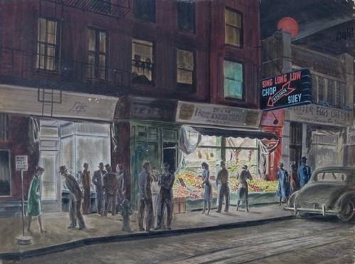
The Fruit Stand
Image used courtesy of Rachel Davis Fine Arts.

When I came across this watercolor by Edward Dobrotka in Rachel Davis Fine Arts' current auction, I knew it was special. It looked, to my eyes, like an excellent illustration of the bustling nightlife on a commercial block in Cleveland in the late 1930s or early 1940s.

Dobrotka, a Clevelander, is best known as an illustrator in some of the early depictions of Superman, created by Clevelanders Jerry Siegel and Joe Shuster.

As a student, in the late 1930s, he was employed in a National Youth Administration (the NYA was a division of the Works Progress Administration - the WPA) program, making paintings, primarily watercolors, of historic buildings in the greater Cleveland area. These paintings provide an excellent way to see these historic buildings in color - subjects that, for the most part, have been lost, and for which the only other documentation is in black and white. About 60 of these paintings, by Dobrotka, are in the collections of the Western Reserve Historical Society - one can obtain a full list by searching for his last name in the museum's catalog.

This painting provides a vibrant view of city nightlife in the late 1930s, in the way a photograph never could. People stand around, perhaps waiting for a streetcar, in front of a store whose name I can't read. To the right, there's a fruit and vegetable market, still open at this late hour. To the right of that, with a tiny doorway, Sing Long Low Chop Suey. On the far right, a store sign lists butter, eggs, and cheese.

The question that's been bugging me is as to the location being depicted. While it's an attractive painting, and valuable as a historical record of the work of an artist, its value as a record of a place is minimal until we can determine just what that place is.

The obvious clue would be to look for Sing Long Low Chop Suey. I don't see any advertisements for an establishement with this name in the pages of the Plain Dealer. I've come across a reference to a "Sing Long Low Chinese Restuarant" in New York City", but the name doesn't seem sufficiently uncommon to rule out Cleveland as a possible location for this painting.

There's enough information in this painting that we should be able to place it on a map, if it is in Cleveland. Streetcar tracks are visible in the road, which narrows down the location. The combination of a 3 story plus brick building, a tiny one story one, and a two story one to the right has to be rare when combined with the streetcar tracks. With enough combing of the Sanborn Fire Insurance Maps for Ohio, one should be able to locate the site.

To further narrow this down, I looked at the areas that Edward Dobrotka covered in his paintings for the NYA. They're primarily in the Ohio City neighborhood, the Flats, and on the near east side (west of, say, East 40th Street). If this is, in fact, Cleveland, it would seem likely he painted this in one of the aforementioned areas.


What do you think? Do you have any ideas as to where this might be? New York readers, do you have any clues?

Tuesday, October 18, 2011

The Last Stand of Eliot Ness

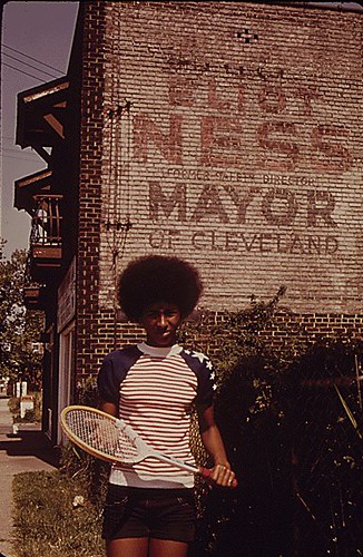
1938 CAMPAIGN SIGN ON BUILDING AT 36TH STREET AND CEDAR AVENUE
Photograph by Frank J. Aleksandrowicz for the Environmental Protection Agency. July, 1973.

I've long heard rumors that a sign, for Eliot Ness's campaign for mayor, was still standing, somewhere on the near east side of Cleveland. Ness served as the city safety director in the 1930s, working to eliminate corruption from the police department. When I came across this historic photograph, taken in the summer of 1973, I had to look further.

The caption indicates that the sign, for Ness's 1938 campaign, is on an apartment building at East 36th Street and Cedar Avenue. This building appears to be gone.

Unless the references I've heard are to another sign, this little bit of Cleveland's history is gone.

Thursday, October 6, 2011

What Lurks Behind The Trees?

The Oakwood Golf Club
IMGP5931

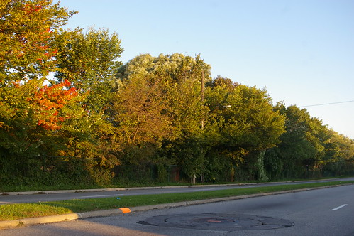
If you've driven down Warrensville Center Road in Cleveland Heights and South Euclid, between Cedar and Mayfield, you've probably noticed this long, dense row of trees on the west side of the road, affording only the occasional glimpse of the golf course that they obscure. Hidden behind the trees is the Oakwood Club, which closed last year. It's the center of a controversy between proponents of redevelopment and those who favor the preservation of green space - but this isn't the venue for that fight.

Today, I'll share a brief history of the club - the first major Jewish country club in the Cleveland area. In coming days, image rights permitting, I hope to delve into the ornate interior of the historic clubhouse. The primary source on the history of the Oakwood Club is Oakwood Club, 1905-1980, by Barnett Bookatz. Many of the facts quoted here are derived from that publication.


Oakwood Golf Club
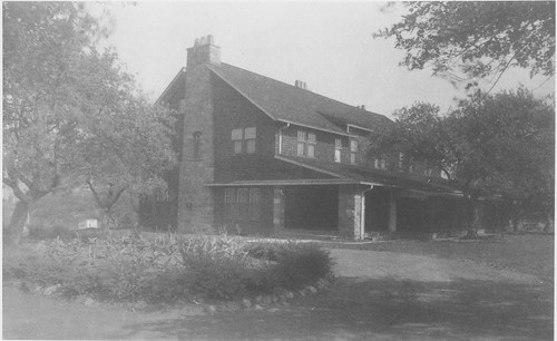
From Art work of Cleveland - 1911, used courtesy of Cleveland Public Library.

Oakwood was founded in 1905, by L.J. Wolf, Morris A. Black, Edward M. Baker, Hascal C. Lang, and M.J. Mandelbaum. The first golf course - 9 holes, designed by Arthur Boggs - opened the following year.

In 1906, Frank B. Meade, a notable Cleveland architect, designed this clubhouse, expected to cost $15,000. The structure, built by Gick & Fry, was completed in 1907. It was either a complete remodel of the existing structure (Bookatz) or a new one (Plain Dealer, February 4, 1906, page 27).

According to Bookatz:
The new features included the grillroom, a men's locer room with 69 double-deck lockers, a "bath-room" with three showers, a double washstand and three lavatories. the first floor held the large living room and dining room, a "Ladies Parlor" witih 20 double-deck lockers, a shower and a bath. Along the entire length of the building ran a 72-foot long porch.
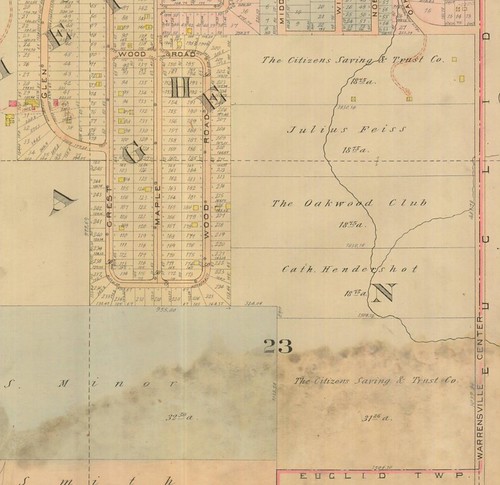
Plate 4, Plat book of Cuyahoga County, Ohio complete in one volume Hopkins, 1914
Detail, Plate 4, Plat book of Cuyahoga County, Ohio, 1914, courtesy of Cleveland Public Library.

It's worth noting that, at the time, the club had much less land than it does today. Their holdings, 19 acres, can be seen near the center of this 1914 map. As it is today, the club includes almost 150 acres - most of area shown on this map as undeveloped. Note the presence of a house and related structures on the parcel owned by the Citizens Saving and Trust Co. The house was located at the end of a long driveway - the double dashed line in pink - the site of the current clubhouse. Some of the outbuildings may remain, repurposed as service structures.
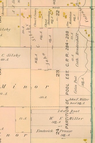
Plate 10, Atlas of the suburbs of Cleveland, Ohio Flynn, 1898
Detail, Plate 10, Atlas of the Suburbs of Cleveland, Ohio - Flynn, 1898, courtesy of Cleveland Public Library.

This 1898 map shows a different configuration of the structures on the property, owned at the time by Catherine Hendershot. A house is present - the yellow box closest to the right side of the image on Hendershot's property.
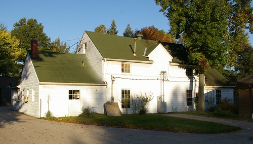
IMGP6046

Why does this matter? Because it tends to suggest that this building, now used as a garage for machinery, may, in fact, be the house that was on the property before the country club was built. All interior detail that might suggest the age has been lost, as shown in these photos.

A second nine hole golf course, designed by Chicagoan Tom Bendelow, was completed in 1915. In 1929, the course was redesigned, as the widening of Warrensville Center Road consumed some of the eastern edge of the course. It remained in this configuration until a redesign in 1972-1973.
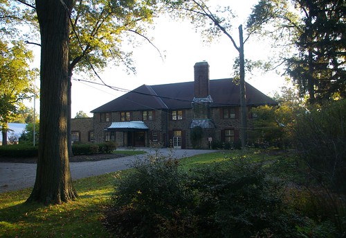
IMGP6004

The Excelsior Club merged with Oakwood in 1930. The increase membership necessitated building a new clubhouse. The building, completed in 1931, was designed by George B. Mayer of Charles R. Greco & Associates. Louis Rorimer, of Rorimer-Brooks Studios, was responsible for the interior decoration.

IMGP5996

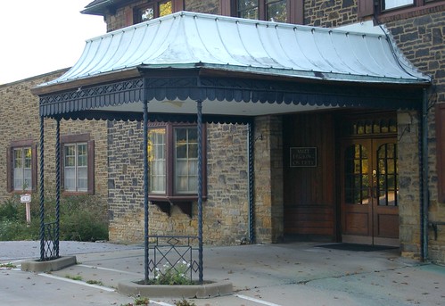
The architectural detail of the clubhouse, which appears to have been expanded several times over the years, is of high quality. This wrought iron and copper awning protected visitors from the elements as they entered the club.
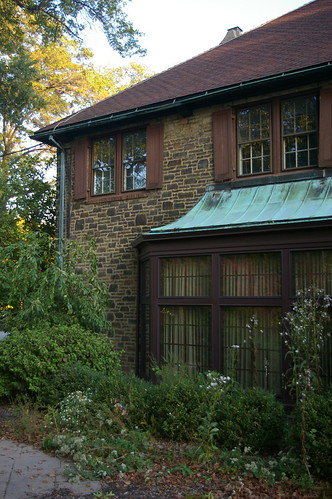
IMGP5936

Details of similar quality continue around the entire structure, as seen here on the south wall.
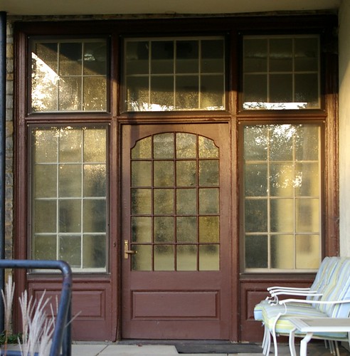
IMGP5952

Even the little details, like this doorway on the east side of the clubhouse, are well-proportioned and pleasing.
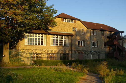
IMGP5945

The east side of the clubhouse, seen here, faces Warrensville Center Road.
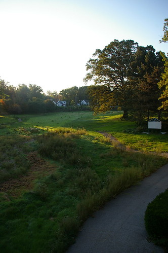
IMGP5963

I'll close with this view from the clubhouse, looking southeast toward Warrensville Center Road, the early morning sun hitting the now unmanicured greens.

In future posts, I hope to address the history of the grounds in more detail, and give you a peek into the clubhouse, providing that I am able to obtain permission to use the images I need. If you have photographs or stories relating to the Oakwood Club, please contact me to share them.

Wednesday, October 5, 2011

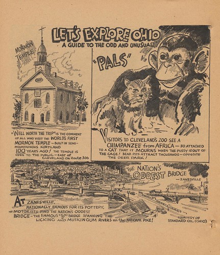
Let's Explore Ohio!

Let's Explore Ohio Coloring Book
Image courtesy of Jordan Smith / What Makes Pie Shops Tick?

John Vacha's latest book, Meet Me on Lake Erie, Dearie! had me thinking about the 1936-37 Great Lakes Exposition, a grand fair held in Cleveland.

In a local collection, I came across this coloring book, created by Sohio, presumably as a giveaway for the exposition. I was going to scan it myself, but then I thought "Hey, I really should see if someone else has done that first."

To my surprise, Jordan Smith / What Makes Pie Shops Tick? had already scanned the book in its entirety. This post includes select pages that deal with the Cleveland area. If you like it, you might want to check out the whole book. Heck, you might even want to print out some of the pages for coloring, for your kids or yourself.

Note: The language and tone are, um, what you might expect for the period, so you might want to read them before giving them to your children.

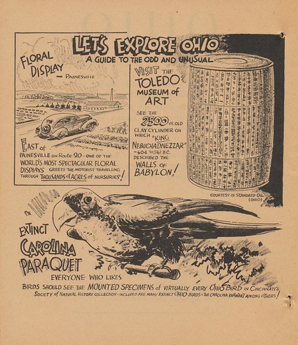
Floral Display
Image courtesy of Jordan Smith / What Makes Pie Shops Tick?

I wonder how many of the nurseries mentioned here are still present.

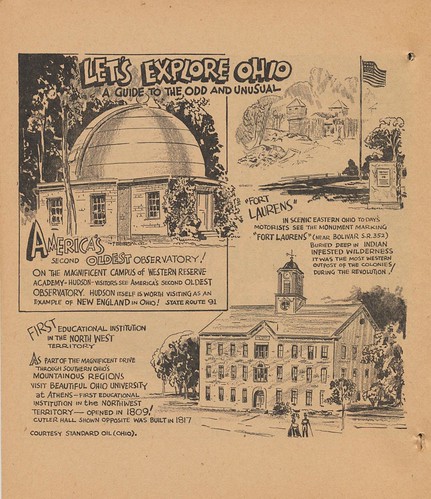
Fort Laurens
Image courtesy of Jordan Smith / What Makes Pie Shops Tick?

The observatory at Western Reserve Academy, in Hudson - the second oldest in the country - is a historic site that seems to mostly be forgotten. The reminder of its existence is most welcome.

Pals
Image courtesy of Jordan Smith / What Makes Pie Shops Tick?

The Kirtland Temple, on the other hand, remains prominent. It's unclear what became of the "Pals" at the Cleveland Zoo.

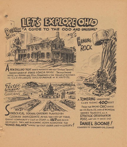
Hanging Rock
Image courtesy of Jordan Smith / What Makes Pie Shops Tick?

The Dunham Tavern receives mention as well.

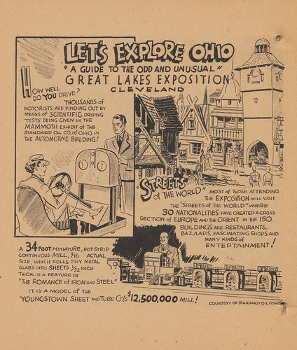
More Great Lakes Exposition
Image courtesy of Jordan Smith / What Makes Pie Shops Tick?

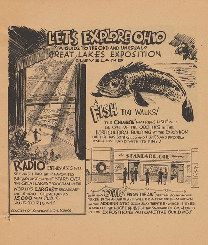
Finally, we're greeted by two pages, sharing the wonders of the Exposition. How many remain wonderous to you, today?

Great Lakes Exposition
Image courtesy of Jordan Smith / What Makes Pie Shops Tick?

Thursday, June 16, 2011

Mystery Photos - Now With More Detail!

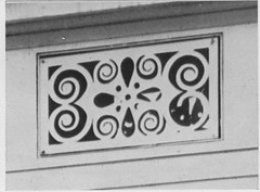
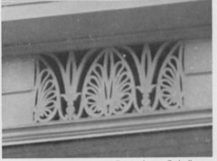
Fret, near Shalersville Fret, Circleville
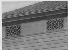
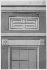
Fret, near Bellvue Fret, Wooster.
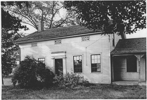
Photos of fretwork at Shalersville, Circleville, Bellevue, and Wooster. By I.T. Frary, from Early Homes of Ohio.

As part of the Cleveland Artists Foundation's exhibit, Designing History: I.T. Frary; Interior Design and the Beginnings of Historic Preservation in Ohio I'm taking an in-depth look at Frary's published works. Chief among these is Early Homes of Ohio, which is now 75 years old. This landmark title was the first to deal with the architectural heritage of this state, and remains an unequaled standard in the field.

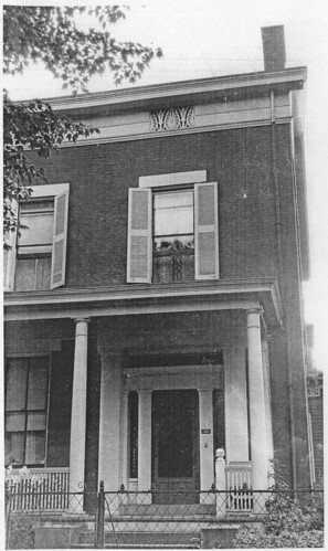
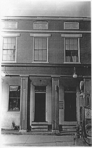
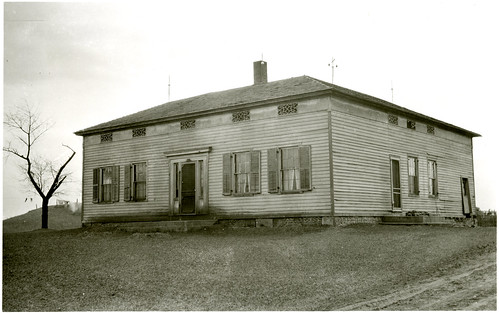
I've been trying to locate all of the structures pictured in Early Homes of Ohio, so that I might document their present condition, and so that others might view them in person. I've located most of them, but some still present difficulties - mostly because, in Early Homes they were only shown in detail. I've scanned photocopies of the images from the collections of the Ohio Historical Society, some of which are presented here.


2611 - House
Courtesy of the Ohio Historical Society.

This house, located "East of Shalersville, Ohio", was photographed by I.T. Frary in 1926. Given the angle of the shadows, and that Frary tended to stay on the main roads, it's probable that the house is on the north side of the road.

House, Circleville, Ohio.  1924.
Courtesy of the Ohio Historical Society.

Frary photographed House, Circleville, Ohio, in 1924. It appears to be the sort of structure that would be in the center of the city.

Wooster, Ohio.  1924.
Courtesy of the Ohio Historical Society.

This brick structure, in Wooster, Ohio, appears to have been built as a commercial structure - thus the two front doors, for better traffic flow. At the time Frary photographed it, in 1924, it housed a gas station, and Church of Christ, Scientist. I've been unable to determine location for said church that corresponds with the evidence suggested here - the building should be close to the street.

House, West of Bellvue, Ohio - 1923 or 1924.
Courtesy of the Ohio Historical Society.

This House, West of Bellvue, Ohio was photographed by I.T. Frary in either 1923 or 1924. This is a scan of an actual photograph, so there's plenty of resolution there, if you need to look at it in more detail. While the house appears square, I suspect, based on the roof line, that it might be L-shaped.


This is just the first group - I'll be sharing more in the coming days. If you know where these houses are, or were, either by address or approximate location, please either comment here or send an email to clevelandareahistory@gmail.com. Thanks!

Friday, April 1, 2011

The Construction of Severance Hall

Untitled-32
Courtesy of Special Collections, Cleveland Public Library

Sometimes, you come across a group of photographs that give you a new perspective on something you think you know reasonably well. Such is this group of photographs, which I stumbled across on Flickr a day or two ago. Their subject: Severance Hall.

This group of 54 black and white photographs comprise a bound volume, Severance Music Hall, held in Special Collections at Cleveland Public Library. Walker and Weeks, the architects for the building, are listed as the authors. The volume illustrates the construction of the structure, from excavation of the foundation, in November of 1929, to the completion of the basic structure, in August of the following year. It does not extend, alas, to the finish work or interior details - but there are plenty of photos elsewhere of the glorious interior.

Untitled-1
Courtesy of Special Collections, Cleveland Public Library

Here, looking south, we see the vacant lot where Severance Hall will be built. It appears that the excavation of the foundation has already begun, yet some debris remains to be cleared. In the distance, slightly to the left of center, is Amasa Stone Chapel, completed in 1911.

Untitled-2
Courtesy of Special Collections, Cleveland Public Library

Looking across the site to the north, we find a site very different from what is present today. Behind the trees to the left, in the distance, is the Cleveland Museum of Art. On the right are two structures - what I believe to be present-day Thwing Center. The top of the tower of the Church of the Covenant is visible in the distance.

The set continues with the excavation of the foundation and the first pieces of structural steel, shown from two perspectives.

Untitled-9
Courtesy of Special Collections, Cleveland Public Library

The construction progresses to this image, dated February 20, 1930. For the first time, we see the basic shape that we know as Severance Hall. It surprised me how early the shape of the structure was recognizable.

Untitled-28
Courtesy of Special Collections, Cleveland Public Library

The photos also document the building of the interior. The form of the main hall can be easily visualized within this steel framework.

Untitled-19
Courtesy of Special Collections, Cleveland Public Library

At first glance, the photos appear almost like snapshots. Then, you realize that, if so, they are very lucky snapshots. Closer examination reveals real care in composition - and the clear use of a view camera, revealed in the carefully aligned verticals in many of the images.

Untitled-20
Courtesy of Special Collections, Cleveland Public Library

Take this exterior view. The photographer clearly considered the composition quite carefully. Further, while some parts of the print are washed out due to the bright sunlight, the general tonal quality suggests that effort was put into making a high quality print. There's a surprising amount of beauty to be found here.

Untitled-36
Courtesy of Special Collections, Cleveland Public Library

A view of work on the roof, dated June 17, 1930, seems a change in style from the vertical emphasis of so many of the rest of the photos. In the distance, to the right, the Church of the Covenant is visible, as is the apartment building at the corner of Ford Drive and Euclid Avenue.

Untitled-38
Courtesy of Special Collections, Cleveland Public Library

The exterior work soon progresses to a form that appears, at least from the outside, to be almost complete.

Untitled-14
Courtesy of Special Collections, Cleveland Public Library

I'll close with one final photo, taken out of sequence. The sun, low in the sky, provides a beautiful source of illumination for this photo. If you just look at the steel framework, you might think that it was a recent construction project. The workers' trucks and the nature of the construction machinery are the only things that give away the date. It seems, in a way, not dissimilar from the scenes that I've witnessed in the construction around the VA Hospital.


This set of photos is both a beautiful set of images and a valuable historical record - something that's worth looking at in its entirety. I give my thanks to the librarian who scanned the photographs and to the Special Collections Department at Cleveland Public Library, where the volume is preserved. It hints at the wealth of material available contained within the collection, available to whoever might venture downtown and ask.