Showing posts with label Historic American Buildings Survey. Show all posts

Thursday, December 1, 2011

The Vanishing Forties - No Longer Quite So Vanished


Rudolph Stanley-Brown (American, 1889-1944). The Vanishing Forties, Cleveland, Ohio. Etching. The Cleveland Museum of Art. In memory of Rudolph Stanley-Brown 1950.185

In my quest for compelling historic imagery, I come across plenty of things that I can't use, simply because I can't figure out where the scene portrayed was physically located. This print, The Vanishing Forties, Cleveland, Ohio, by Rudolph Stanley-Brown, is one such case - one that's been bugging me since I first saw it, more than a year ago.

It's likely that Stanley-Brown made the print in 1924 or 1925 - he entered The Thirties and The Fifties into the Cleveland Museum of Art's May Show that year (May Show Database).

Mould
Photograph by Carl Waite for the Historic American Buildings Survey, November 2, 1936. Detail of the original, used courtesy of the Library of Congress.

The style of the house is very similar to two Cleveland structures, both now lost - the H. Mould house, at 2637 Cedar Avenue, and the Leonard Case homestead - documented by the Historic American Buildings Survey (HABS), one of the many make-work projects that came under the auspices of WPA in the 1930s.

Leonard Case Homestead, 1295 East Twentieth Street, Cleveland, Cuyahoga, OH
Photograph by Carl Waite for the Historic American Buildings Survey, November 2, 1936. Detail of the original, used courtesy of the Library of Congress.

I covered the Leonard Case house, which was built c. 1820, in detail, back in 2009. The H. Mould house is said to have been built later - 1860 - but the large central chimney makes me suspect an earlier date. I would guess, based on the title of the work, The Vanishing Forties, that the house was built in the 1840s - or at least that's when the artist thought it was built.

Detail, T.P. May residence
Detail, T.P. May residence. Rendered in 1935 by Isadore Wasserstrom for the Historic American Buildings Survey.

Yesterday, I was browsing through the HABS drawings for this region, when I came across the T.P. May residence, at 1458 East 12th Street, Cleveland, Ohio.

Detail, T.P. May residence
Detail, T.P. May residence. Rendered in 1935 by Isadore Wasserstrom for the Historic American Buildings Survey.

It looked similar to the house in Stanley-Brown's print - but only similar - there were several significant differences. The bases of the columns were different, as were the windows. The roof lacks the vertical lines, too, but that could be the artist's choice.

I was going to dismiss the possibility of the HABS drawings being of the same structure that Stanley-Brown depicted, but, out of stubbornness - I really wanted it to be the same one - I persisted, trying to identify details that were the same.

The tops of the columns and the trim above them are the same. So are the proportions of the porch. The same can be said for the spacing of the windows and the pitch of the roof. Both have brick foundations, at a time when stone would have been more common.

Detail, T.P. May residence
Detail, T.P. May residence. Rendered in 1935 by Isadore Wasserstrom for the Historic American Buildings Survey.

The front steps cemented my opinion that The Vanishing Forties does, in fact, depict this house. This detail, of the floorplan, illustrates them clearly. It can also be seen, in less detail, in the renderings above. Note that the steps aren't entirely in front of the porch, as would usually be the case, but partially set into it. Perhaps this was done when the sidewalk was widened, or perhaps the house was originally this way, allowing the builder to make the house a little bigger than he might have otherwise. Whatever the cause, it's an uncommon detail, one that confirms the identity.

I've seen other houses where the HABS architects reconstructed the original appearance of structures that have been changed considerably. One example is the H. M. Gillette residence, near Wellington, Ohio. In that case, a porch had been added around most of the house, concealing much of the detail. They were able to make measured drawings to show it as it was, and used an earlier photograph, by I.T. Frary, to aid in the illustration.

The HABS documentation includes some background information about the house:
The East Twelfth Street House was built previous to 1865 on the easterly end of T.P. May's sub-division. T.P. May was an influential early settler of Cleveland and a member of the first Board of Health. His sub-division extended from Erie Street (E. 9th) to Muirson Street (E. 12th) along the northerly side of what in 1865 became the extension of Superior Street...

The house while still having evidence of good design and sturdy construction has been used in recent years as a ware house and consequently many of the better details have been destroyed.

T.P. May residence, sheet 1 T.P. May residence, sheet 2
T.P. May residence, sheet 3 T.P. May residence, sheet 4
T.P. May residence. Rendered in 1935 by Isadore Wasserstrom for the Historic American Buildings Survey.

The four pages of renderings provide an incredible amount of detail - the hardware is included, as is the exact dimensions of the seam on the metal roof. With the information present here, one could build a house virtually identical to the original. The biggest obstacle would likely replicating the method of construction - modern tools simply don't leave the same tool marks as tools used in the 1840s.

One final note: the building in the background is the Hotel Statler, at the corner of Euclid Avenue and East 12th Street.

Friday, July 16, 2010

The Isaac Warren house

Warren House, Lakewood, Ohio
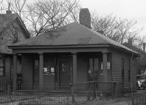
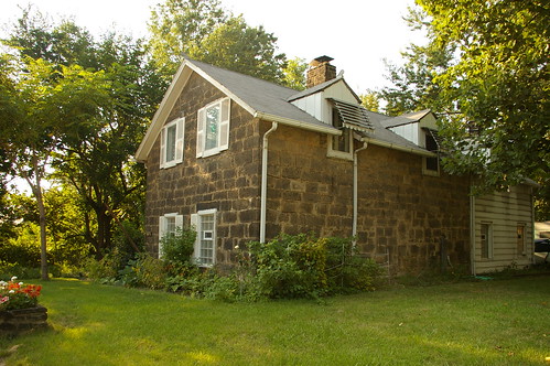
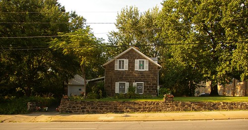
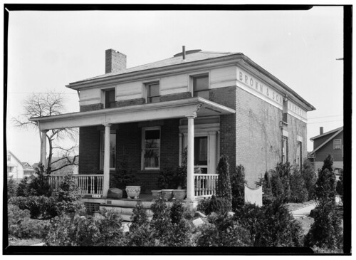
Photograph by Carl Waite, April 28, 1936, for the Historic American Buildings Survey

I was browsing through the photographs and documentation for Cuyahoga County from the Historic American Buildings Survey (HABS), the make-work project created in 1933 as part of the New Deal to record our country's most important historic structures. Three houses in Lakewood are included in this documentation. Two of them, the 
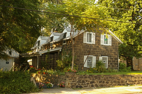
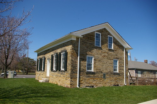
Nicholson House and the John Honam House (more often known simply as the Old Stone House) are still standing and are familar Lakewood landmarks. The third, however, I did not recognize.

According to the HABS documentation, the 
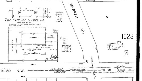
Warren House was located in Lakewood at the intersection of Warren and Fisher Roads. There is no Fisher Road in Lakewood at the present. A Fischer Road exists, running east-west, south of Interstate 90, but it does not intersect with Warren Road. If it was continued east, the point where it would intersect with Warren would be in Cleveland, not Lakewood.
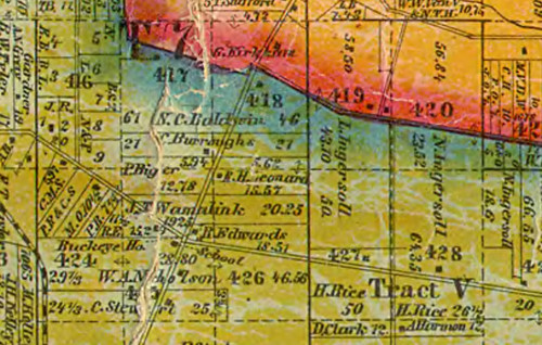
The 1914 Plat Book of Cuyahoga County provided the answer. The map in question shows that the road now known as Lakewood Heights Boulevard was then known as Fisher. Further, it shows a brick, 1 1/2 story house on the northeast corner of the intersection, consistent with the Warren House.

Warren Road and Lakwood Heights Boulevard

This 1929 Sanborn Fire Insurance Map confirms that the building on the northeast corner of the intersection is, beyond a reasonable doubt, the Warren House. The outline of the house, which is very distinctive, matches exactly the outline given in the first drawing of the house in the HABS documentation.

I wanted to know more about the house and its inhabitants. I contacted Mazie Adams, director of the Lakewood Historical Society, who provided valuable research, including many sources that I would not have otherwise been able to check. I really appreciate her help on this project.

I haven't been able to learn much about the house or its inhabitants. While many sources that deal with Lakewood history recognize its importance, they are either unable to provide much information, or they provide information that doesn't check out. In this post, I'll try to illustrate what we do know.


Isaac Warren settled in this part of Rockport Township in 1822, according to the sources for virtually all of our biographical information on the Warren family. (Early Days of Lakewood, pages 29-30, The Lakewood Story, page 71, and Mrs. Townsend's Scrap Book, page 9) Isaac Warren is said to have been a stockholder or investor in the Connecticut Land Company. I doubt, as some say, that he was an "original stockholder", as there is no mention of his name in the index to The Connecticut Land Company: A Study in the Beginnings of the Colonization of the Western Reserve (Claude L. Shepard, Western Reserve Historical Society, 1916.)

I find it to be more likely that he settled here in 1824, the year that Warren Road was put through, following an old Indian trail, between Detroit Avenue and Lorain Avenue.(Early Days of Lakewood, page 69) I base this on his purchase of land from Garrit and Sarah Smith, of Watertown, Connecticut, in that year. (AFN: 182406250001) It is unclear whether Isaac Warren chose to settle here because of the road or if the road was built because of his interests.

Isaac Warren was from Waterbury, Connecticut. (AFN: 182406250001) He was married to Amelia Bronson, of New Bedford, Connecticut.

Mrs. Townsend's Scrap Book, page 9, provides the most complete account of their family:

They came overland from New Bedford, Connecticut. Mrs. Warren was Amelia Bronsen [Bronson] before her marriage, and had a great local reputation as an expert spinner of wool and weaver of homespun, which was the only cloth obtainable in those days. It was in fact "all wool and a yard wide". Mrs. Warren was born in Connecticut in 1799. Isaac Warren was a descendant of Dr. Joseph Warren of Boston who was killed in the Revolutionary War at the battle of Bunker Hill. Isaac Warren was a prominent citizen of the pioneer days and one of the biggest land owners, having several hundred acres. Mrs. Phelps is his only descendant living in Lakewood now. She lives on Clifton Boulevard with her daughter. Her son is married.

There were seven children born to the Warren Family; Sabra and Rebecca, daughters; John, Lucius, Abraham, Isaac and Sherman, sons. Lucius, Abraham and Isaac moved to Iowa and became large property owners. Sherman Warren settled in Missouri. Sabra married, Silas Gleason, son of pioneer Jeremiah Gleason, and Rebecca became the wife of John Johnson.

The only daughter of Rebecca, who for many years was regarded as mentally unbalanced due to a siege of scarlet fever, fell heir to all the Warren acreage. She was finally judged sane and left her estate to the Warren family, after giving a large slice to a German housekeeper who had cared for her in her last days.

There's a problem with this account, which is repeated in the other sources - that Isaac Warren was the son of Dr. Joseph Warren, who died in the Battle of Bunker Hill. The 1860 Census records Isaac Warren's birth in 1782, seven years after the Battle of Bunker Hill. Even if we discount the Census record, it is unlikely, though not impossible, that Warren would have married someone half his age. Joseph Warren could not have been Isaac's father. I suspect that either Isaac's father was another individual named "Joseph Warren" or that Dr. Joseph Warren was some other familial relation.

The remainder of the major facts from Mrs. Townsend's Scrap Book are consistent with the other sources on the Warren family. Townsend goes into more detail than the others, and, unfortunately, didn't provide any footnotes as to the sources of her information.

Little other information exists about Isaac Warren and his family. The 1830, 1840, 1850, and 1860 U.S. Censuses place him in Rockport Township. He is listed as the property owner for part of the land (though not the site of this house) on the 1852 Blackmore and 1858 Hopkins maps. After that, I can find no record of him. There isn't any mention of his death in the Plain Dealer, nor in the Cleveland Necrology File. I've been unable to locate any property transfers that might suggest the dispersal of his estate or conveyance to his heirs. We can be reasonably sure that it was before 1874 - the Atlas of Cuyahoga County, Ohio published that year shows his land having been split up to various parties.

Who was Isaac Warren? He was a reasonably well-off farmer. This is suggested by his land holdings and his house. He owned, at one point, at least 140 acres.

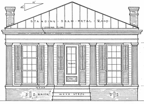
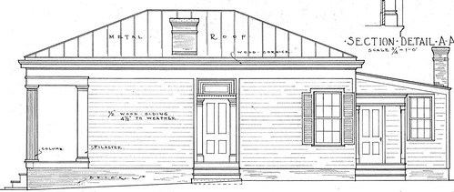
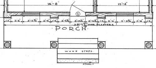
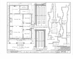
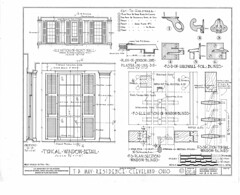
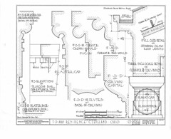
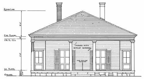
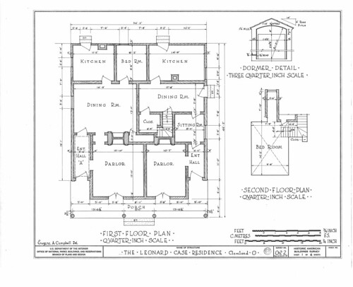
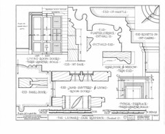
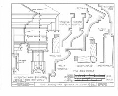
The Historic American Buildings Survey (HABS), in addition to the photograph above, provided detailed architectural drawings of the house. These include exterior views, details of mouldings and the front door, and floorplans for the first and second floors.

The Warren House, drawing 3

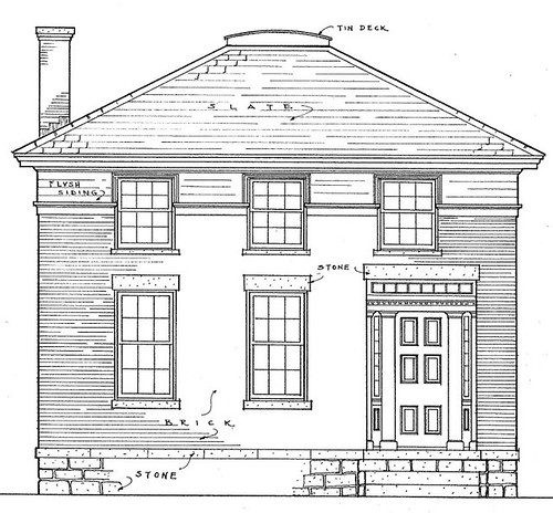
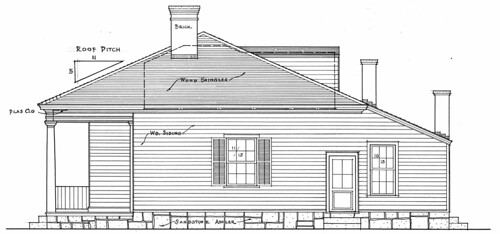
This detail view shows the exterior of the house as it appeared before the addition of the porch. The bricks were probably a raw sienna or ochre hue, rather than the red that we tend to expect, as that is the color of the clay in the immediate vicinity. (This is based on my experience growing up just down the street, near Alger and Lakewood Heights Boulevard.) This would have been consistent with the Price French residence, built in 1828 at the southwest corner of Detroit and Wyandotte. The French residence was noted to have been made from "mustard-colored" bricks. (Lakewood by Thea Gallo Becker, Arcadia, 2003, page 10.)

The window sills were made of cement. The lintels were stone. The sloping part of the roof was slate, while the (nearly) flat part was tin.

The HABS chose to document the house because it was one of the oldest houses in Lakewood. They estimate the date of construction as 1835, though they note "Local historians and early owners are unable to shed much light on who the original owners and builders are." A similar assessment of the date is made in Early History of Lakewood (page 77-78). The Survey's notes state that the walls were 13 inches thick, consistent with this date rather than a more recent one.

Warren house (doorway), Lakewood, Ohio

The front door is of a similar form, though more ornate than the front door of the Brainard residence, thought to have been built at about the same time. By the time of this 1936 photograph by Carl Waite for the Historic American Buildings Survey, the sidelights and transom surrounding the front door of the Isaac Warren residence had been filled in. It is illustrated in detail in this rendering. The documentation of this as a significant architectural further reinforces the significance of the detail of the Brainard house and the need to preserve it.

The Warren House, drawing 2 (detail)

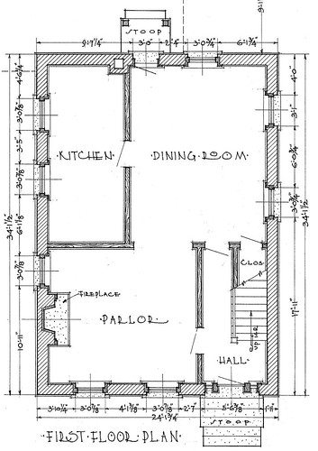
Each floor of the Isaac Warren residence was about 700 square feet. The drawings, details of this one, done in 1936 by the HABS, help tell this family's story.

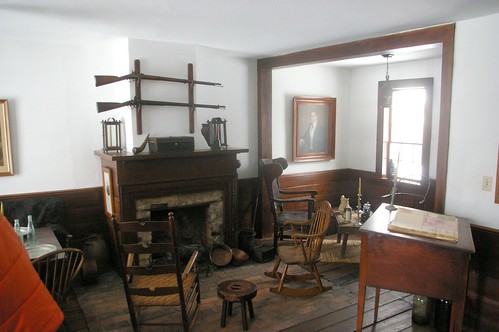
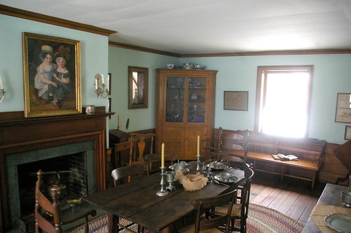
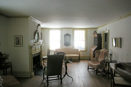
If you entered the house through the front door, you would be greeted by a hallway with a set of stairs going up to the second floor on the right. At the end of the hallway, a door led to the dining room. From this same vantage point, to the left, a door led into the parlor. The parlor, which measured about 13 x 15 feet, centered on a large fireplace, the primary source of heat in the house. A large open doorway joined the parlor to the dining room. The dining room, about 14 x 16 feet, provided plenty of space for the Warren family and any guests or farm laborers. The kitchen was connected by a door to the dining room. Another door off the dining room led outside. The ceiling on the first floor was 8'8" high.

The Warren House, drawing 2 (detail)

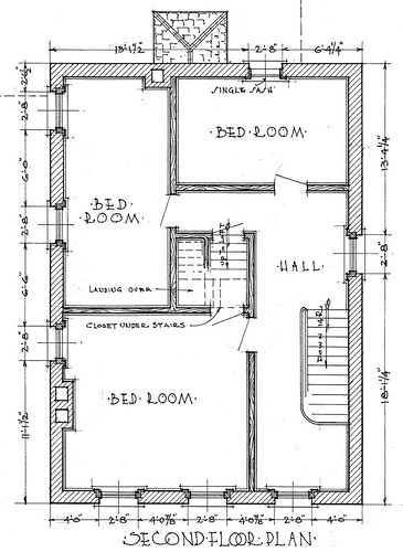
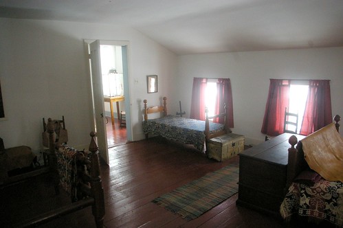
The second floor had somewhat lower ceilings - 7'3" at the highest point. The stairs from the first floor led to a hallway with four doors. Three led to bedrooms. The fourth led to a winding staircase to a small loft.

The loft would have been a rather cramped space - about 4' high at the highest point. The dimensions of the space with a ceiling this high were about 20' x 5'. One might assume that this was also used as a bedroom.

The question remains as to when the house was built. It is shown on the 1858 Hopkins map, on a 44 acre parcel owned by J. Johnson. However, the map also illustrates a house on a larger parcel of land still owned by I. Warren. That house was located east of Warren Road, slightly south of where Westland Avenue now runs.

We know that Isaac Warren built a house when he first moved to Rockport Township, and that this one was built later. Could the house owned by Isaac Warren in 1858 have been the first house he built here? Or, might Isaac Warren's 1858 house have been built even later?

The 1830 Census shows 7 people in the Isaac Warren family. The 1840 Census shows 9. By 1850, the number was reduced to 3. I suspect that the house was built in about 1835, as has been suggested, as the family was growing and needed more space.

Another reasonable possibility is that it was built in the 1840s. The site of the house and about 25 acres of land were transferred from Isaac Warren to his son, John B. Warren, in 1840. (AFN: 184003030002) John Warren does not appear in the 1840 Census, yet by 1850, it had grown to 7 members. The house might have been built by him for his family.

In 1850, John and Ann Warren and four children (Catharine, Martha, Mary, and Lucy) were living in this house. Lucius Warren also lived with them.

Isaac Warren lived until after 1860. (1860 U.S. Census) Amelia Warren, his wife, died sometime before 1850. (1850 U.S. Census) I've been unable to locate obituaries or burial records for them.


John H. Johnson, a freshwater sailor born in New York, married Rebecca Warren sometime before 1850. (HABS, 1850 U.S. Census) In 1853, he purchased this house and 44 acres of land, north and east of the intersection of Warren Road and Lakewood Heights Boulevard, from John B. Warren and Ann Eliza Warren. (AFN: 185304160001) This is illustrated in the 1858 Hopkins map of Cuyahoga County. He worked the land as a farmer. (1870 U.S. Census) John and Rebecca had one child, Henrietta, born circa 1860.

Very little information exists regarding Johnson. He isn't mentioned in the chapter of Early Days of Lakewood titled "Late Pioneers, 1840-1865" nor in 1865-1889 chapter. The HABS documentation provides some notes as to John Johnson's family, according to oral history. "Mr. Johnson's folks resided on Johnson Street, also known as Water Street in Cleveland, Ohio. Mr. Johnson's cousin and Nettie Johnson, a Cob Girl, operated a sanituarium at Green Springs, Ohio. There is a Johnson Homestead at Green Springs." I haven't been able to put this information to any use.

By 1874, their holdings appear to have increased to more than 60 acres, as shown on the Atlas of Cuyahoga County, Ohio. At least some of this increase was likely due to the dispersal of Isaac Warren's estate. It's worth noting that on this map, as well as maps published in 1892 1898, and 1903 Rebecca P. Johnson is listed as the owner of the property, not John H. Warren. In the 1898 atlas, their property is divided into two, a north part south half. The same is the case for the 1903 atlas - there are north and south parts. The land the house was on is in the northern part.

Rebecca Johnson died between 1870 and 1880. (1870 and 1880 U.S. Censuses) I have been unable to located an obituary or burial record for her. This makes her being listed on the maps as the owner of the land more curious. She was, in fact, the owner of at least part of it - a 1904 property sale lists Henrietta as the sole heir of Rebecca Johnson. (AFN: 190405130005)

John H. Johnson died in the residence, on the morning of February 17, 1905. A funeral was held in the Congregational church at Kamm's corners, at 2pm on Sunday, February 18. John Johnson was buried in Alger Cemetery. (Cleveland Necrology File)

Henrietta Johnson remained in the Isaac Warren residence for the rest of her life. (1880 and 1900 U.S. Census) In the early 20th century, the parcels of land around the house were gradually sold off. This is shown in this plate from the 1914 Plat Book of Cuyahoga County. It also illustrates that several outbuildings were present around the house, including two that were 1 1/2 stories high.

Henrietta Johnson died in the Warren residence on October 6, 1917, at 6:45pm. The address of the house was listed as 2281 Warren Road. The funeral was held at her late home on Tuesday, October 9, at 2pm. Henrietta was buried in Alger Cemetery.

The status of the house after Henrietta Johnson's death is difficult to decipher. I haven't had any luck tracing the property transfers during the 1920s and early 1930s. This is due to the rapid split of the parcels in the area into residential lots and the transfer of the property among various entities due to foreclosure in the early 30s.

Perhaps these fragments will be of use to some future researcher.

Cadillac 7 pass tour.; good tires and motor; will sacrifice for $250; sell quick; can be seen at 2281 Warren rd., Lkwd.
Plain Dealer, May 11, 1926, page 25

Hennie-Alice Evelyn, beloved daughter of John and Coral (nee Fretter), sister of Charles, George, Mildred, Pearl and Mrs. Frank Burbank, Thursday, May 26. Funeral services at the late residence, 2281 Warren road, Lakewood, Saturday, May 28, at 1:30 p. m
Cleveland Necrology File

Mr. and Mrs. Grover C. Weed, 1388 Brockley Avenue, Lakewood, announce the marriage of their daughter, Ruth, to Mr. Francis Chambers, son of Mr. and Mrs. Frank Chambers, 2281 Warren Road, Lakewood, which took place Dec. 5, 1931.
Plain Dealer, October 10, 1932, page 33.

We Carry Triple-X Soil-Bil-Der and all othre Stadler Fertilizers. Also the complete line of Nursery Stock.
Brown & Son Nursery
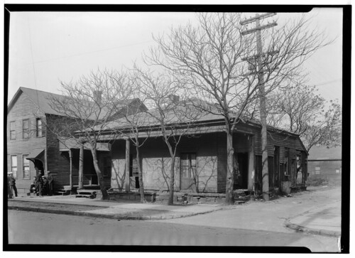
Warren and Fisher Rds. - LAkewood 1957
Plain Dealer, April 26, 1936, page 23

Brown & Son's sign can be seen painted on the side of the house in the lead photograph. By 1938, they had moved to 18240 Detroit Avenue (Plain Dealer, March 12, 1938, page 21) where they remained until 1962. (Plain Dealer, June 22, 1962, page 54)

The property was sold at sheriff's sale in 1936, where it was purchased by Bertha H. Gund. (AFN: 193603230012) In 1938 John J. Gund and Bertha H. Gund sold the property to Field, Richards and Shepard, Inc. (AFN: 193803100082) The transfer included an interesting provision:
"Excepting, however, and reserving to the Grantor the brick house and wooden shed now on said premises (but not the land on which they are situated), together with the right to enter upon said premises and remove said house and shed at any time within thirty days from and after the date hereof; provided, however, that if said house and shed are not removed from said premises within said thirty day period, title thereto shall pass to and vest in the Grantee..."


This house feels familiar to me. I can't quite place it. This provision makes me wonder if it was moved, and I have, in fact, seen it somewhere else. Mazie Adams, director of the Lakewood Historical Society, checked the permits at city hall, but was unable to locate either a demolition or moving permit for this address.

Later in 1938, Field, Richards and Shepard, Inc. sold the property to the Standard Oil Company. (AFN: 193806040032) A gas station was built on the site soon after.


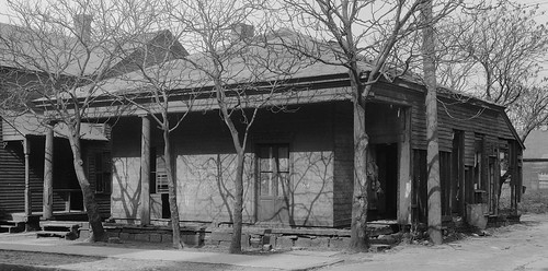
The gas station, Meme's Sohio, at 2285 Warren Road, can be seen in this 1956 photograph, used courtesy of the Cleveland Memory Project. This wider view, also from 1956, provides a bit of a feel of the neighborhood at the time.

The property has since become a rental car agency.

Friday, June 25, 2010

Cleveland Area Landmarks: A proposal

It's been suggested that we need to identify the historic properties of greatest interest to us, so that we're not always scrambling around trying to save this or that building at the last minute. I agree. There are already various registries for such properties, among others the National Register of Historic Places and Cleveland Landmarks. Other cities, towns, and villages in the area also have landmark lists.

The problem with these is that they require the consent of the owner for inclusion. If an individual wants to demolish a structure, it's not in their best financial interest to allow it to become a landmark. Further, there's the (often incorrect) perception that landmark status will make it more difficult for them to sell or alter the property.

We need a landmark registry based purely on the historic merits of the structure. These structures will be called Cleveland Area Landmarks. We'll publish a list of them here. Inclusion in the list will let people know ahead of time that we, as a community, care about these buildings, and that we're willing to fight to preserve them as part of our history.

I'd suggest starting with those properties already included in local city landmark registries. To that I'd add those included in the National Register of Historic Places (NRHP) and the Historic American Buildings Survey / Historic American Engineering Record. In addition, we should strongly consider sites that were nominated to the NRHP or as city landmarks, but for which the owner did not consent.

It would be worth considering quite carefully the buildings listed in the major books on the built history of our region, including Eric Johannesen's Cleveland Architecture 1876-1976 and Mary-Peale Schofield's Landmark Architecture of Cleveland.

Then, we should see what has been omitted. We should look at this county on a street by street basis and see what buildings and neighborhoods define us. The NRHP criteria seem a reasonable standard to follow.

I'll begin by compiling a list of all the properties in the aforementioned registries.

The next step will be for you to help identify buildings for inclusion. I'll create a basic standard for the nominations, which will include at least one photograph and a justification for the nomination. On a regular basis, these nominations will be posted here, and you, the readers, will vote as to whether they meet the criteria for Cleveland Area Landmarks. By voting for a property, we will indicate our commitment to its preservation.

We'll keep our eyes on the Cleveland Area Landmarks in our respective neighborhoods, so that we, as a group, can take action when they are threatened. This registry is the first step toward real progress in preserving the history of the greater Cleveland area.

Monday, March 22, 2010

The Arcade: one of the best interior spaces in the country

The Arcade

Now that it is finally spring and we're all thinking about leaving our houses again, I thought I'd address the best public interior space in Cleveland, as well as one of the very best, if not the best, in the country.


The Arcade, which runs between Euclid Avenue and Superior Avenue, was completed in 1890. It is a National Historic Landmark. The architects were George H. Smith and John Eisenmann. The space was created as a shopping center, with offices on upper floors. The Euclid Avenue entrance is higher than the Superior Avenue one, which effectively creates two main floors.

This photograph was taken in 1965 by Martin Lindsey for the Historic American Buildings Survey (HABS). It shows the Superior Avenue façade prior to the installation of an architecturally insensitive canopy by the Hyatt Regency Hotel, which occupies part of the building.


This photograph, also by Martin Lindsey for HABS, illustrates the Euclid Avenue façade. The first two levels were remodeled, with the polished marble seen here, in 1939.

The Historic American Building Survey uses the following text to explain the significance of this space:
The Cleveland Arcade is a particularly noteworthy example of the skylighted arcade - a building type that is one of the most unique contributions of nineteenth century architecture to the urban scene. Functionally and commercially this prominent Cleveland structure is an arcade, for it provides a passageway between two large urban thoroughfares and it contains many shops and offices related to the individual companies. But its tiers of galleries and dramatic use of interior space make it architecturally more skin to the light courts of the multi-stories commercial structures which were developed before the introduction of sufficiently brilliant interior artificial lighting. In construction the Arcade is mixed in technique and materials and reflects the rapid changes in high buildings in the 1880s and 1890s - an era that saw the birth of the skyscraper.

It's worth noting that they also have extensive documentation and architectural drawings of the Arcade, which will surely be of interest to anyone wanting to do further research on the building.


This postcard, from the Cleveland Memory Project at Cleveland State University, illustrates the interior of the Arcade at night, in the 1920s. It shows the relatively small amount of light generated by the existing illumination sources, as mentioned above.

As of this writing, the Arcade was currently working through the foreclosure process. If you haven't been in a while, stop the next time that you are in downtown Cleveland. If you go through it every day, slow down a little to enjoy it.

I don't know what the best use for this space is. Stores now demand more space than they used to. Many businesses have left downtown. Whatever this space is used for in the future, it should be in such a way that allows for public access.

The Arcade is the most architecturally significant building in Cleveland. It houses an incredible interior space. Let's find some way to take advantage of it.

Wednesday, February 24, 2010

The Dunham Tavern

Dunham Tavern

Have you ever noticed this building on Euclid Avenue, standing next to a massive old industrial building, and wondered what it was doing there? The building is the Dunham Tavern museum. Located at 6709 Euclid Avenue, the Tavern is the oldest building still standing on its original site in the city of Cleveland. The oldest part of the tavern, seen here to the right and rear, was built in 1824 to serve travelers, at a time when Euclid Avenue was the major east-west thouroughfare. The main part of the building was built in 1842.

Kitchen

Entry to the museum is through a door on the side which opens into the oldest part of the building. This space contains a large kitchen with living quarters on the second floor.

Front staircase

Guests would have entered through the front hall. Note the wood paneling lining the hallway and stairs.

Tavern

The tavern itself is furnished with antiques that are generally of the period, and usually of the style that would have been present originally. Very few of the actual original furnishings remain.

Dining room

The dining room is located between the tavern and the front hall.

Parlor

The parlor, on the opposite side of the front hallway, provided a space for guests to sit and relax.

Bedroom

The second floor includes several bedrooms, all furnished with period antiques.

Library

The library is also located on the second floor. The cabinets are said to be from a ship, and to have been built in the 1760s.

Original wallpaper fragment

Many interesting artifacts are displayed on the second floor as well. One is this framed fragment of the original wallpaper.

Dresser (original to house)

Another is this dresser, built circa 1825-1840, which is one of the few antiques that is original to the house.

The museum is surrounded by impressive grounds, which include gardens and a barn. I will share photos of the gardens come spring.

I have posted many more photos of the interior of the house on Flickr. The Historic American Buildings Survey (HABS) has extensive drawings detailing the house as well as the stables, which are no longer present. One may note that the HABS photograph shows a porch that is no longer present. The porch was a later addition which has since been removed.

It's amazing that the Dunham Tavern was able to survive as long as it did at this location, in the heart of the city. It is made even more impressive by the massive brick and concrete structure next door to it. I hope that that structure remains, because it provides some context as to just what this museum has survived through.

At $3, the Dunham Tavern Museum is an excellent deal. It is open Wednesdays and Sundays, 1-4 pm.

Monday, December 28, 2009

Why the 50000 ton Mesta Press matters

mesta7

When I first heard about the damage to the 50,000 ton Mesta press at the Alcoa works in Cleveland, my reaction was minimal. It sounded like yet another attempt to retain some small bit of the once great industrial heart that made Cleveland what it is today. I had seen the Historic American Engineering Record's documentation of the press, but again, I didn't know the current significance of the it.

The 50,000 ton Mesta Press has been designated a Mechanical Engineering Landmark by the American Society of Mechanical Engineers (ASME), one of about 250 sites worldwide to recieve this recognition. Their brochure for the dedication ceremony helps explain the historical significance of the press in the history of the Cleveland and the aerospace industry.

The 1981 program provides the following background:

The Mesta 50,000 ton hydraulic closed die forging press, this country’s largest forging machine, is currently producing the largest light metal forgings in the world.

This massive forging tool actually had its genesis during the days of World War II. Allied intelligence teams inspecting German aircraft downed behind our lines discovered that they contained extremely large and complex major structural elements. Our appraisal of the situation, confirmed immediately after the end of the war, was that the Germans had produced these aircraft components with the aid of huge forging and extrusion presses possessing capabilities far in excess of those in our own industrial complex.

The implications were far-reaching. If forgings and extrusions large enough to comprise key aircraft structural elements could be produced in this country, not only would fabrication time be reduced greatly, but costs would be lowered. In addition, such a technique held the promise of forging materials with greater strength-weight ratios, an extremely desirable attribute from the standpoint of aircraft design. Just before the conclusion of the war, the United States embarked upon an urgent program to build a press able to match our estimates of the productive capability of the German equipment. The Mesta Machine Company of Pittsburgh was awarded a contract to construct an 18,000 ton forging press, and the Wyman Gordon Company of North Grafton, Massachusetts, was selected to operate it. Since the press was so enormous, a pattern to be followed when the press program went into full swing was established — a plant had to be built around the press to
house both it and its supporting equipment. The war ended, however, before the project was fully completed.

When our technical/industrial teams visited Germany after the cessation of hostilities, they found that the Germans had indeed developed and learned successfully to operate presses ranging up to 30,000 metric tons. In all, three heavy die forging presses, two with a capacity of 15,000 metric tons and one with a 30,000-ton capacity, were discovered in more or less useable condition. Three extrusion presses in the 5,000 metric ton category were also located. As part of the postwar settlement, the United States acquired the 15,000 and 5,000 metric ton presses which were channeled into the Air Force Heavy Press Program. The 30,000-ton press, however, was seized by the Russians. With the Soviets in possession of so large a press, our Heavy Press Program received added impetus.


mesta6

As of November, it seems that the press will be rebuilt. I don't see what other options ALCOA has with regard to the matter. The press has produced some of the largest single structural elements for air and spacecraft. These are parts that simply cannot be produced in any other facilities.

The 50,000 ton Mesta Press should be seen as a vital element in the history of industrial Cleveland, as significant as the Hulett Ore Unloaders.

Tuesday, November 24, 2009

Rodolphus Edwards House

Sandstone Greek Revival house

I've driven by this house, at 10701 Buckeye Road, in Cleveland, Ohio, any number of times, but it wasn't until a couple months ago that I really looked at it. At 30 miles an hour, it looks like a late 19th century house. I wondered if it might be earlier, but the proportions didn't seem right - the pitch of the roof, most notably. I now realize that this is one of the most significant houses standing in the area.

Sandstone Greek Revival house

At a slower pace, you can see the tool marks in the stone. Note the wide variety of marks. You don't see this in later houses, once it was possible to mechanically smooth stone. There must have been a nearby quarry, which seems to have supplied the owners of this house enough material for both the wall and the garage.

Sandstone Greek Revival house

I suspect the aluminum-sided wing to the rear is newer than the sandstone wing. The small chimney suggests the structure as a kitchen, added later.The vertical siding begins at about the same point as the trim boards on this Greek Revival, so perhaps the installer did this to work with the existing siding. The builder managed to keep the proportions almost identical between the two halves.

Rudolphus Edwards, Jr. house

The east side of the house shows evidence of a first floor window, centered on the wall, which has since been filled in. The dormers are a later addition. The galvanized finials on the dormers and the main roof are a nice detail.

It's too bad that the first floor windows have been filled in with glass block. The photograph in Mary-Peale Schofield's Landmark Architecture of Cleveland, published in 1976 shows the house with first floor windows that match those on the second floor. The windows appear to be bi-fold.

Security bars are a more reversible option than glass block. I've seen custom wrought iron ones that would detract less from the appearance of the house.

Sandstone Greek Revival house

The original appearance of the west side of the house is unclear. It was probably the entrance - we don't have evidence of an entrance on the other side or on the front. The entrance would likely have had some sort of ornamentation, probably sidelights, if keeping with the style of the period. Perhaps these details are still present, hidden under the awning.


It is difficult to provide an exact date for this house. The 1858 Hopkins Map of Cuyahoga County, Ohio, should show the house. It illustrates the property of one R. Edwards, 18.51 acres, at the northeast corner of the intersection of the two major roads, now Buckeye and Woodhill. The Edwards house should be where the .51 is on the map. It is provided courtesy of Rails and Trails. Another version is available from Cleveland Public Library.

The 1874 Atlas of Cuyahoga County, Ohio shows the same property as the 1858 Hopkins map, still belonging to R. Edwards. The house is shown in the proper location, on the map of Newburgh Township.

Rodolphus Edwards' father had the same first name. They were not commonly referred to as junior and senior. Further, he was one of the original surveyors of the Western Reserve. He built a very popular tavern, which is the building shown on the map in the Edwards property. He had considerable property holdings in the greater Cleveland area. This all makes him a far more prominent individual and makes it harder to learn about Rodolphus, Jr.

The following is my best guess. In April, 1836, Hanna and Starks Edwards transferred property to Rodolphus Edwards, parts of lots 424, 425, and 426 (AFN 183605040001). The map shown above shows holdings by Rodolphus Edwards in lots 425 and 426 - I'm confident that this was the property transferred by Hanna and Starks. Further, I'm reasonably confident that the property was being transferred to the junior Rodolphus because it seems unlikely that the senior would be reacquiring property he had given to his son at that late stage in his life.

Further, it seems likely that Rodolphus (sometimes spelled Rudolphus) would have begun work on this residence shortly after purchase of the land. He would have been 18 years old at the time.

The manner of the stone masonry provides further evidence of the date - it is more primitive than what I've seen in houses in the area from the 1850s. This narrows the date range. We can be sure that the house was built before about 1855, and reasonably confident before 1845. I want to say it was built in 1836 - but I need more evidence, either physical or documentary. It is plausible, but unlikely, that the house was built before 1836.

The issue of dating the Rodolphus Edwards houses isn't made any easier by this exceprt from the Annals of the Early Settlers Association, no. 4, p. 47. It states that Edwards was living in the old tavern, which was at the northeast corner of what is now Woodhill and Buckeye.
Rodolphus Edwards, for short called "Dolph," and of whom I am about to write, can be numbered among the early pioneers of Cuyahoga county, having come here away back in 1797. He settled on a large tract of land now known as Woodland Hills, but formerly called Butternut Ridge. In addition to farming he kept a public inn or tavern, as they were called in those days, for the accommodation of the traveling public, which was a place of resort for the old pioneers who used occasionally to meet and over their glasses of cider-flip pass away the time recounting their trials and adventures of pioneer life. This old house is still standing, having been converted into a private residence, and is now occupied by Rodolphus Edwards, Jr., who himself is well advanced in years.


I've tried to learn who Rodolphus Edwards, Jr., was, with little success. One can assume that, like almost all of the settlers living this far outside the city at the time, he was a farmer. The Annals of the Early Settlers Association, no. 11, p. 465-466 provides the following memorial, which ends up being more of a biography of his father.
Rodolphus Edwards, whose death occurred at his home on Woodland Hills, on Thursday, August 21, 1890, was a son of Rodolphus Edwards. The latter was a member of the surveying party in the Western Reserve in 1798, in which year he arrived at Cleveland, together with Nathaniel Dan, wife, one son and three daughters, Samuel Dodge, father of the late Henry Dodge, Nathan Chapman, Stephen Gilbert and Joseph Landon. These eleven persons were the total permanent additions to the population of Cleveland during the year 1798. Mr. Edwards had followed surveying previous to coming here, and the compass used by him from 1792 to 1798 may be seen in the rooms of the Historical Society, to which it was donated by Mr. Edwards, recently deceased. Mr. Edwards, Sr., the first year he was in Cleveland built a log cabin "under the hill" at the foot of Superior street. He remained there, however, but a short time, and on account of the malaria at the mouth of the Cuyahoga, removed in a year or two, with two or three other families, to the high land running from Doan's Corners to Newburg. He appears to have been a man of much intelligence and great good sense and judgment, and was very useful in the early days of the Reserve. He was chairman of the first town meeting held in Cleveland, April 5, 1802, at the house of James Kingsbury. Mr. Edwards came here from Chenango county, New York, but the family is of Connecticut origin, the father of Rodolphus, Sr., having been born in Tolland county, that State, in 1739. Later he also came to Cleveland, and died at the house of his son, in 1831, aged ninety-two years. His name was Adoinjah. He was in the war of the Revolution under General Stark, who as he drew his forces up to attack Burgoyne, said to his men: "Fellow-soldiers, there is the enemy. If we do not take them Molly Stark will be a widow to-night." Rodolphus Edwards, Sr., heard from the lips of his father much of the history of that great war for the independence of this country, as well as the part taken in it by his father, and in memory of the gallant and brave general under whom his father served, named his first son Stark, who was born December 6, 1808, and died June 19, 1877.


Rodolphus, Jr., was born July 15, 1818. He had a sister, Sally, who married Patrick Thomas, son of William Thomas, who was an uncle of Major-General George H. Thomas. The branch of the Edwards family from which Mr. Edwards was descended was of much prominence in Connecticut, and gave to that State and country many distinguished names. Among them may be mentioned Jonathan, who graduated at Yale College in 1720, and who became president of Nassau Hall College, and is mentioned as one of the most celebrated and orthodox divines in New England. The latter's son, Jonathan, was president of Union College, at Schenectady, and noted for great reasoning power and strength of mind. Rodolphus Edwards was a member of the Early Settlers' Association, and took great satisfaction in talking of the early days of Cleveland. He was well known in the ea'sterly part of the city, and had the respect and esteem of the community through a long and active life. His father bought a tract of land on what is now known as Woodland Hills, and kept a hotel there for many years. A large part of this property yet remains in the possession of the family, and here, on the old homestead, the son died, Thursday last, aged seventy-two years.
Leader.


Oldest Stone House, Lakewood, Ohio

To help make sense of the Rodolphus Edwards house, I looked for one to compare it to. The John Honam residence, built c. 1838, came to mind. The house, now a museum in Lakewood Park, is also known as the Oldest Stone House. It was originally located at 1369 St. Charles Avenue, in Lakewood. Prior to the move, it was documented by the Historic American Buildings Survey (HABS). The Cleveland Memory project also has several historic photos of the house.

Both houses are about the same size, made from the same materials, and were built at about the same time. The windows on the front of the Honam house are not original, but the ones on the sides are. The HABS drawings suggest that the front and back of the Honam house were originally three bays wide, giving it similar proportions to the Edwards house. The floorplan of the Edwards house is probably similar to the one provided in the HABS drawings for the Honam house.

The most obvious difference between the two houses is the level and quality of detail. The Honam house has detailed gables, nicely trimmed, while the Edwards house has simple ones. For the Honam residence, the stones were cut into smaller, more regular blocks, while for Edwards, they remain more rough, and with obvious tool marks.

There was a quarry close to the Honam residence, on what is now Cook Avenue, just a couple hundred feet away. The closest quarry to the Edwards residence that I've been able to locate on a map was on what is now Kinsman Road, about a mile away. Of course, a quarry might have been closer and simply not be on the map.

Edwards and Honam were both farmers, seemingly concerned with building houses that were either more durable or that conveyed a sense of greater importance. Perhaps Honam had more time to build his residence. Perhaps he was simply more skilled.


Rodolphus Edwards, Jr. house

What does this all mean?

This house is a critical piece of our local history. There are very few houses in the area that are this old in any condition. Combine this with the relatively unmolested nature of the structure and we have a building that simply can't be ignored.

The current owners seem to be taking good care of the house. They also own several adjacent lots, which total about a half acre. If there was ever the inclination to make this house into a museum or to bring the property back to the original rural nature, this would be helpful.

There is absolutely no reason that this house should not be considered for Cleveland Landmark status. With the appropriate documentation, it would be easy to get it into the National Register of Historic Places.

Thursday, November 12, 2009

The Leonard Case house

Leonard Case House

Leonard Case (1786-1864), a businessman and prominent early Clevelander, moved to the city in 1816 and built this house shortly after, at the corner of Rockwell Avenue and East 3rd Street.

Leonard Case House

These drawings were made in 1933 as part of the Historic American Building Survey (HABS). HABS was a federal program created to document historic buildings and structures and to put to work unemployed architects and photographers. The meticulous measured drawings and photographs that came as a result are a true treasure.

Leonard Case House

According to the documentation from HABS:
The Case Homestead at Rockwell Avenue and East 3rd Street was sold at public auction to Attorney Charles E. Chadman for $340. It was moved from this site to a new location at 1295 East 20th Street.

At the time the Case home was built the total population in Cleveland was between 1000 and 1500. This home as one can readily understand from the size of the population was built by one of the very early settlers and consequently is of considerable historic value. East 20th Street at the time of the removal of the house was considered "quite a ways out", and a select residential district; today, however, this territory is considered a "slum area".

The house has served various purposes since its removal, one of the last uses was that of a restaurant. The members of the Historical Building Survey Squad who measured the building, did so in the nick of time, in that but a few days after completing the survey, the building began to disappear, as will be noted from the photographs. This destruction was in all probability the work of vandals or possibly people who were in dire circumstances and in need of fuel.


Leonard Case House

Leonard Case House Leonard Case House

In addition to floorplans, the drawings include the various mouldings and bits of trim.

It is not clear exactly when the house was moved to the location on E. 20th Street. It is shown at that location in the 1881 Hopkins atlas and the 1886 Sanborn fire insurance atlas, so it was obviously moved before that date.

The site on East 20th Street is now surface parking.